Image:Map - DR Congo, major languages.svg
From Wikipedia, the free encyclopedia
Map_-_DR_Congo,_major_languages.svg (SVG file, nominally 729 × 679 pixels, file size: 42 KB)
| |
This is a file from the Wikimedia Commons. The description on its description page there is shown below. |
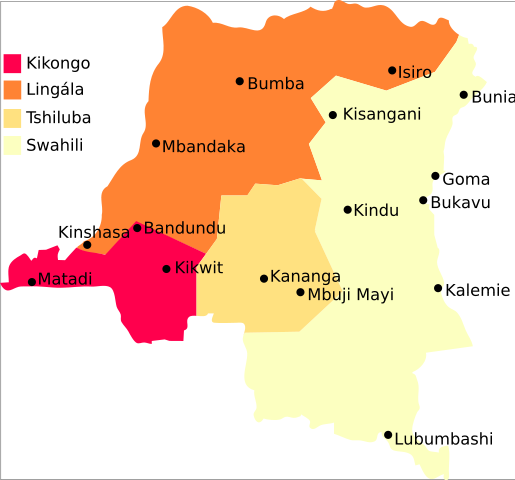
Summary
Map of major languages of the DR Congo
2005, Denis Jacquerye
See
Licensing
|
File history
Click on a date/time to view the file as it appeared at that time.
| Date/Time | Dimensions | User | Comment | |
|---|---|---|---|---|
| current | 10:49, 16 October 2006 | 729×679 (42 KB) | Rasulo | (Added Bandundu and Kikwit.) |
| 20:00, 31 May 2006 | 729×679 (40 KB) | Moyogo | (no transparency) | |
| 22:45, 15 February 2006 | 729×679 (40 KB) | Moyogo | ||
| 22:41, 15 February 2006 | 744×1,052 (42 KB) | Moyogo | (Map of major languages of the DR Congo <br/> 2005, Denis Jacquerye See *http://www.radiookapi.net/ *http://www.tlfq.ulaval.ca/axl/afrique/czaire.htm Category:Linguistic maps Category:Maps of Africa Category:African language families [[Catego) |
File links
The following pages on Schools Wikipedia link to this image (list may be incomplete):