Almaty
2008/9 Schools Wikipedia Selection. Related subjects: Geography of Asia
| Almaty Алматы |
|||
|
|||
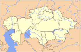
| Location in Kazakhstan | |||
| Coordinates: | |||
|---|---|---|---|
| Country | |||
| Province | Almaty Province | ||
| First settled | 10th-9th century BC | ||
| Founded | 1854 | ||
| Incorporated (city) | 1867 | ||
| Government | |||
| - Akim ( mayor) | Akhmetzhan Yesimov | ||
| Area | |||
| - Total | 324.8 km² (125.4 sq mi) | ||
| Elevation | 500 - 1,700 m (1,640 - 5,577 ft) | ||
| Population (2005) | |||
| - Total | 1,226,300 | ||
| - Density | 3,776/km² (9,779.8/sq mi) | ||
| Time zone | BTT ( UTC+6) | ||
| Postal code | 050000 - 050063 | ||
| Area code(s) | +7 727 | ||
| ISO 3166-2 | ALA | ||
| License plate | A | ||
| Website: http://www.almaty.kz | |||
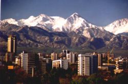
Almaty ( Kazakh: Алматы; formerly known as Alma-Ata, also Verniy, (Верный)) is the largest city in Kazakhstan, with a population of 1,226,000 (as of 1 August 2005), which represents 8% of the population of the country. It was the capital of Kazakhstan (and its predecessor, the Kazakh SSR) from 1929 to 1998. Despite losing its status as the capital, Almaty remains the major commercial centre of Kazakhstan.
Name
The name "Almaty" is the adjective form of the noun for Apple, and thus is popularly translated "rich with apple" and "appleness"; the older Soviet-era Russian version of its name, Alma-Ata, originates from a mistake (literally means "Grandfather of apples"). In the surrounding region, there is a great genetic diversity among the wild apples; the region is thought to be the ancestral home of the apple, and the wild Malus sieversii, is considered a likely candidate for the ancestor of the modern domestic apple.
Demographics
Ethnic groups (2003):
- Kazakh 43.6 %
- Russian 40.2 %
- Uyghur 5.7 %
- Tatar 2.1 %
- Korean 1.8 %
- Ukrainian 1.7 %
- German 0.7 %
According to the USSR Census of 1989, population of Almaty was 1,071,900; Kazakhstan Census of 1999 reported 1,129,400.
History
Prehistoric Almaty
During 10-9 BCE in the Bronze Age the first farmers and cattle-breeders established settlements on the territory of Almaty.
During the Saka’s period (from 7 BCE to the beginning of the Common Era), Almaty was chosen for residence by Saka tribes and later Uisun tribes inhabiting the territory north of the Tian Shan mountain range. The evidences of these times are numerous burial tumuli and ancient settlements, especially giant burial mounds of Saka tsars. The most famous archaeological finds are the Golden man from the Issyk Kurgan, Zhalauly treasure, Kargaly diadem, Zhetysu arts bronze (boilers, lamps and alters). During the period of Saka and uisun governance, Almaty became the early education centre.
Middle Ages
The next stage of Almaty evolution is attributed to the Middle Ages (8th – 10th centuries) and characterized by the city culture development, transfer to the settled way of living, farming and handicraft development, emerging a number of towns and cities on the territory of Zhetysu.
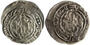
In 10th – 14th centuries, settlements situated on the territory of the so called "Big Almaty became the part of trade routes of the Silk Road. At that time, Almaty became one of the trade, craft and agricultural centers on the Silk Road and possessed an official mint. The city was first mentioned as Almatu in old books in the 13th century.
15th - 18th centuries
In 15th - 18th centuries, the city was on the way to degradation as trade activities were condensing on this part of the Silk Road. Notwithstanding, this period was saturated with very important political events that had significant impact on the history of Almaty and Kazakhstan as a whole. It was a period of crucial ethnic and political transformations. The Kazakh state and nation were founded here, close to Almaty.
These lands also witnessed the tragic developments related to the Dzungar intervention and rigorous efforts of the Kazakh to protect their land and preserve independence. In 1730 the Kazakh defeated the Dzungar in the Anyrakay mountains, 70 km to north-west from Almaty. It was a critical moment of the Patriotic War between Kazakhs and Dzungars.
Foundation of Verniy
On 4 February 1854 the new history of the city started from strengthening the Russian piedmont Fort Verniy nearby the Zailiysky Alatau mountain range between Bolshaya and Malaya Almatinka rivers. The construction of the Verniy Fort was almost finished by autumn 1854. It was a fenced pentagon and one of its sides was built along the Malaya Almatinka. Later, wood fence was replaced with the wall of brick with embrasures. Main facilities were erected around the big square for training and parading.
In 1855 the first displaced Kazakh appeared in Verniy. Since 1856, Verniy started accepting Russian peasants. They founded the Bolshaya Almatinskaya Stanitsa ( Cossack village) nearby the fortification. The inflow of migrants was increasing and led to construction of the Malaya Almatinskaya Stanitsa and Tatarskaya (Tashkentskaya) sloboda. It was the place of settlement for Tatar mechants and craftsmen.
In 1867 the Verniy Fort was transformed into the town and called Almatinsk. However, the population did not like the new name of the town and soon the town was re-named as Verniy.
According to the First City Plan, the city parameters were 2 km on the south along Almatinka river, and 3 km on the west. The new city area was divided into residential parts, and the latter – into districts. Three categories of the city buildings were distinguished. Buildings of the first and second categories were two-storied or, at least, one-storied constructions with the high semi-basement. Buildings of categories I and II were erected around and in the centre of the city, others – on the outskirts.
On 28 May 1887 at 4 a.m. the earthquake almost totally destroyed Verniy in 11-12 minutes. Brick buildings were mostly damaged. The earthquake deteriorated the image of the city. As a result, people were inclined to build up one-storied construction made of wood or adobe.
20th century Almaty
Almaty from the Revolution of 1917 to World War II
In 1921, the joint solemn sitting was summoned for the participation of the representative of government regional and sub-regional institutions, professional trades, the Muslim people to make a decision to assign a new name to Verniy – Alma-Ata.
In 1926, the Council of Labour and Defence approved the construction of the Turkestan-Siberia Railway railway that was a crucial element of the republic reconstruction, specifically on the east and southeast of the republic. The Turkestan-Siberia Railway construction was also a decisive economic aspect that foreordained the destiny of Alma-Ata as a capital of Kazakh ASSR. In 1930 the construction of the highway and railway to the Alma-Ata station was completed.
On 2 March 1927, It was the initiative of the Central Executive Committee of the Kazakh Republic to transfer the capital from Kyzyl-Orda to Alma-Ata. The VI Kazakhstani Congress approved this initiative.
On 29 April 1927, it was officially decided on the sitting of the RSFSR Committee to transfer the capital of the Kazakh Autonomous Soviet Socialist Republic from Kyzyl-Orda to Alma-Ata.
Besides, the Alma-Ata airport was opened in 1930 and people from the capital of Kazakhstan could fly now from Alma-Ata to Moscow. Alma-Ata became the air gate to Kazakhstan. Transformation of the small town into the capital of the Republic was supplied by the large-scaled construction of new administrative and government facilities and housing.
Given the transfer of the capital of Kazakhstan to Alma-Ata , in 1936 the Architecture and Planning Bureau elaborated the General Plan aimed at re-creating Alma-Ata as the new cultural and comfortable capital of Kazakhstan. The Plan was based on the existing rectangular system of districts that would further be strengthened and reconstructed.
Almaty in World War II
During the World War II the city territory was changed to a large extent. To organize the home front and concentrate industrial and material resources, the residential stock was compressed to arrange accommodation for 26,000 persons evacuated. Alma-Ata hosted over 30 industrial facilities from the front areas, 8 evacuated hospitals, 15 institutes, universities and technical schools, around 20 cultural institutions, etc. Motion picture production companies from Leningrad, Kiev and Moscow were also evacuated to Alma-Ata.
Owing to self-denying labour, over 52,000 Alma-Ata residents were awarded. 48 residents were granted with the title of the Soviet Union Hero. Three rifle divisions were raised in Alma-Ata , including the well-known 8th Panfilov’s division, along with 2 rifle battalions and 3 aviation regiments that were raised on the basis of the air club of Alma-Ata.
Almaty from 1945 to 2000
From 1966 to 1971, 1,400,000 square meters of public and cooperative housing were put into operation. Annually, around 300,000 square meters of dwellings were under construction. It was the period of constructing earthquake-proof multi-storied buildings. Construction unification and type-design practice diversified architectural forms. At that time were constructed lots of schools, hospitals, cultural and entertainment facilities, including the Lenin’s Palace, Kazakhstan Hotel, sport complex “ Medeo”, etc.
The Medeu Dam, designed to protect the city of Almaty and the Medeo skating rink from catastrophic mudflows, was built in 1966 and reinforced a number of times in the 1960s and 1970s.
Since 1981, the underground Almaty Metro construction project has been developed.
On 16 December 1986 Jeltoksan riot took place in response to General Secretary Mikhail Gorbachev's dismissal of Dinmukhamed Kunayev.
In 1993 the government made a decision to rename Alma-Ata. The new name of the city is Almaty.
In 1997 the President of the Republic of Kazakhstan Nursultan Nazarbayev approved the Decree to transfer the capital from Almaty to Astana.
On 1 July 1998 was passed the Law concerning the special status of Almaty as a scientific, cultural, historical, financial and industrial centre.
21st century Almaty
The new 2030 General Plan of Almaty was developed in 1998 and aims at forming ecologically safe, secure and socially comfortable living conditions. The main objective is to promote Almaty’s image as a garden-city. One of the components of the General Plan is to continue multi-storied and individual construction, reorganize industrial territories, improve transport infrastructure and launch Almaty Metro.
Sights
Kök Töbe
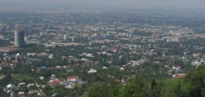
An aerial tramway line connects downtown Almaty with a popular recreation area the top of Kök Töbe ( Kazakh: Көктөбе, which means 'Green Hill'), a mountain just to the southeast. The city television tower, Alma-Ata Tower, is located on the hill, as well as a variety of amusement-park type attractions and touristy restaurants.
Fountains
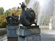
According to the city's Department of Natural Resources and Resource Use Management, as of 2007 the city has 125 fountain groups or isolated fountains. Among them is the "Oriental Calendar" Fountain, whose 12 sculpture figures represent the 12 animals of the Kazakh 12-year animal cycle (similar to its Chinese counterpart).
Olympic aspirations
Almaty was an official candidate to host the XXII Olympic Winter Games, but was eliminated from consideration after it failed to be included in the "short list" of candidate cities. Almaty won its bid to host the 2011 Winter Asian Games.
