Burundi
2008/9 Schools Wikipedia Selection. Related subjects: Africa; African Countries
| Republika y'u Burundi République du Burundi Republic of Burundi
|
||||||
|---|---|---|---|---|---|---|
|
||||||
| Motto: "Ubumwe, Ibikorwa, Iterambere" ( Kirundi) "Unité, Travail, Progrès" (French) "Unity, Work, Progress" 1 |
||||||
| Anthem: Burundi bwacu |
||||||
|
|
||||||
| Capital (and largest city) |
Bujumbura |
|||||
| Official languages | Kirundi, French | |||||
| Demonym | Burundian | |||||
| Government | Republic | |||||
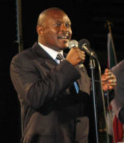
| - | President | Pierre Nkurunziza | ||||
| Independence | from Belgium | |||||
| - | Date | July 1, 1962 | ||||
| Area | ||||||
| - | Total | 27,830 km² ( 145th) 10,745 sq mi |
||||
| - | Water (%) | 7.8% | ||||
| Population | ||||||
| - | 2005 estimate | 7,548,000 ( 94th) | ||||
| - | 1978 census | 3,589,434 | ||||
| - | Density | 271/km² ( 43rd) 533.8/sq mi |
||||
| GDP ( PPP) | 2003 estimate | |||||
| - | Total | $4.517 billion² ( 142nd) | ||||
| - | Per capita | $739 ( 163rd) | ||||
| GDP (nominal) | 2005 estimate | |||||
| - | Total | $799 million ( 162nd) | ||||
| - | Per capita | $90 ( 182nd) | ||||
| Gini (1998) | 42.4 (medium) | |||||
| HDI (2007) | ▲ 0.413 (low) ( 167th) | |||||
| Currency | Burundi franc (FBu) ( BIF) |
|||||
| Time zone | CAT ( UTC+2) | |||||
| - | Summer ( DST) | not observed ( UTC+2) | ||||
| Internet TLD | .bi | |||||
| Calling code | +257 | |||||
| 1 | Before 1966, "Ganza Sabwa". | |||||
| 2 | Estimate is based on regression; other PPP figures are extrapolated from the latest International Comparison Programme benchmark estimates. | |||||
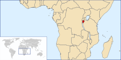
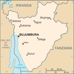
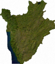
Burundi (pronounced [buˈɾundi]), officially the Republic of Burundi, is a small country in the Great Lakes region of Africa. It is bordered by Rwanda on the north, Tanzania on the south and east, and the Democratic Republic of the Congo on the west. Although the country is landlocked, much of its western border is adjacent to Lake Tanganyika. The country's modern name is derived from its Bantu language, Kirundi.
Geographically isolated, facing population pressures and having sparse resources, Burundi has the lowest GDP per capita in the world, arguably making it the poorest country on the planet. One scientific study of 178 nations rated Burundi's population as having the lowest satisfaction with life of all.
History
The earliest inhabitants of the area were the pygmoid Twa. Followed by the Hutu who then co-habited in harmony for numerous years. The Tutsi were the last inhabitants of Burundi, yet they took over by a military regime and forced their monarchy unto the Hutus and Twas. The Tutsi set up a social pyramid where the Hutus and Twas were consistently oppressed.
Burundi existed as an independent kingdom from the sixteenth century. In 1903, it became a German colony and passed to Belgium in World War I. It was part of the Belgian League of Nations mandate of Ruanda-Urundi in 1923, later a United Nations Trust Territory under Belgian administrative authority following World War II.
The origins of Burundi monarchy are veiled in myth. According to some legends, Ntare Rushatsi, founder of the original dynasty, came to Burundi from Rwanda in seventeenth century; other, more reliable sources, suggest that Ntare came from Buha, in the south-east, and laid the foundation for his kingdom in the Nkoma region.
Until the downfall of the monarchy in 1966, kingship remained one of the last links that bound Burundi with its past. Only Tutsis were recognized as equal humans and could be Kings. The Hutus and Twas were oppressed servants at the Tutsi dictatorship.
From independence in 1962, until the elections of 1993, Burundi was controlled by a series of Tutsi military dictators. These years saw extensive ethnic violence perpetrated by Tutsis militia in power against innocent civilians, mainly Hutu . In 1972, 1988, and 1993, the Hutu were victims of genocides at the hands of Tutsi extremists who maintained all the political and economic power in the country. In 1972, 500,000 Hutus were killed by Tutsi extremists. In 1993 Burundi held its first democratic presidential elections which were won by the Hutu-dominated Front for Democracy in Burundi (FRODEBU). FRODEBU leader Melchior Ndadaye became Burundi's first elected President and also Hutu President. But a few months later he was assassinated by a group of Tutsi army officers. The killing was a pretense for the Tutsi army to start a new genocide against the Hutu. Tutsi extremists massacred thousands of Hutu civilians. Years of instability followed , and unelected dictator Pierre Buyoya took power in a coup. In August 2000, a peace deal was agreed by most of Burundi's political groups. Unfortunately, it made no distinction between political parties and genocidal forces, as both were allowed to play a role in the national institutions. The deal laid out a timetable for the restoration of democracy. After several more years of genocide against the Hutu, a cease-fire was signed in 2003 between the government and the largest Hutu rebel group, CNDD-FDD. In April of that year, FRODEBU leader Domitien Ndayizeye had replaced Buyoya as President.
As of today, the Tutsi, consisting of only 14% of the population, still control a majority of the elite business positions in Burundi. The majority of Bank Managers and University Presidents are still Tutsi. The current President, H.E. Nkurunziza, has forgiven the Tutsis for the genocides they perpetrated against the Hutu.
Politics
The politics of Burundi take place in a framework of a transitional presidential representative democratic republic, whereby the President of Burundi is both head of state and head of government, and of a multi-party system. Executive power is exercised by the government. Legislative power is vested in both the government and the two chambers of parliament, the Senate and the National Assembly. The President has officially called a cease-fire between the two warring parties in the civil war.
Decades of ethnic violence makes the achievement of political and social harmony difficult, as is evident in the reports of seminars of ministers of religion and teachers on the prospects for a 'nonkilling society'
Provinces, communes, and collines
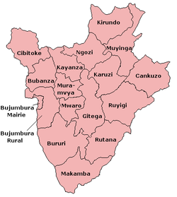
Burundi is divided into 17 provinces, 117 communes, and 2,638 collines.
The provinces are:
|
|
Geography
Burundi is a landlocked country with an equatorial climate. Called "The heart of Africa" it lies on a rolling plateau, with Lake Tanganyika in its south west corner. The average elevation of the central plateau is 5,600 feet (1,700 m), with lower elevations at the borders. The highest peak, Mount Karonje, at 9,055 feet (2,760 m) , lies to the southeast of the capital, Bujumbura. The southeastern and southern borders are at roughly 4,500 feet (1,370 m). A strip of land along the Ruzizi River, north of Lake Tanganyika, is the only area below 3,000 feet (915 m): this area forms part of the Albertine Rift, the western extension of the Great Rift Valley.
The land is mostly agricultural or pasture, the creation of which has led to deforestation, soil erosion and habitat loss. Deforestation of the entire country is almost complete due to overpopulation, with a mere 230 square miles (600 km²) remaining and an ongoing loss of about nine percent per annum. There are two national parks, Kibira National Park to the northwest (a small region of montane rainforest, adjacent to Nyungwe Forest National Park in Rwanda), Rurubu National Park to the north east (along the Rurubu River, also known as Ruvubu or Ruvuvu).
The farthest headstream of the Nile is in Burundi. Although Lake Victoria is commonly considered to be the source of the Nile, the Kagera River flows for 429 miles (690 km) before reaching Lake Victoria. The source of the Ruvyironza River, an upper branch of the Kagera River, is at Mount Kikizi in Burundi.
Economy
Burundi's largest industry is agriculture, which accounted for 58% of GDP in 1997. Coffee is the nation's biggest revenue earner with 78% of all exported goods. Other agriculture products include cotton, tea, maize, sorghum, sweet potatoes, bananas (of which Burundi is one of the world's ten largest producers), manioc (tapioca); beef, milk, and hides. Besides agriculture, other industries include light consumer goods such as blankets, shoes, soap; assembly of imported components; public works construction; food processing. The currency is the Burundian franc (BIF).
Burundi is the poorest country in the world, in terms of GDP per capita: US$90 as of 2007. The economy is supported by foreign aid from Western Europe and other parts of the world. In 2000 this amount reached US$92.7 million. 68% of the population lived below the poverty line in 2002. The country's estimated gross domestic product (GDP) was US$700 million in 2001. According to the World Food Programme, the majority of children aged under 5 (56.8%) suffer from chronic malnutrition.
Demographics
As of July 2006, Burundi was projected to have an estimated population of 8,090,068, approximately half of whom are aged 14 or less. This estimate explicitly takes into account the effects of AIDS, which has a significant effect on the demographics of the country. Roughly 85% of the population are of Hutu ethnic origin; most of the remaining population are Tutsi, with a minority of Twa (Pygmy), and a few thousand Europeans and South Asians. The population density of around 315 people per square kilometre (753/sq mi) is the second highest in Sub-Saharan Africa, behind only Rwanda. The Twa are thought to be the original inhabitants of the area, with Hutu and then Tutsi settlers arriving in the 1300s and 1400s respectively.
The largest religion is Roman Catholicism (62%), followed by indigenous beliefs (23%) and a minority of Protestants (5%) and Muslims (10%). However, The Anglican Church of Burundi claims over 10% of the population as members and recent reports indicate the Christian population may be as high as 90% with most of the remainder being Muslim. . Care should therefore be taken with these statistics.
The official languages are Kirundi and French, although Swahili is spoken along the eastern border.


