Image:Map - DR Congo, major languages.svg

From Wikipedia, the free encyclopedia
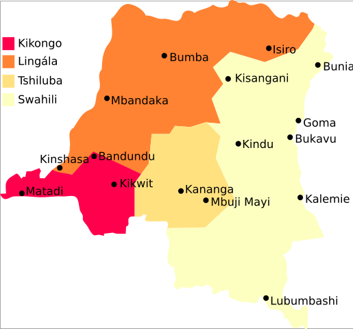
Map_-_DR_Congo,_major_languages.svg‎ (SVG file, nominally 729 × 679 pixels, file size: 42 KB)

Wikimedia Commons logo This is a file from the Wikimedia Commons. The description on its description page there is shown below.
Commons is a freely licensed media file repository. You can help.

Summary

Map of major languages of the DR Congo
2005, Denis Jacquerye

See

Licensing

I, the copyright holder of this work, hereby publish it under the following license:
Creative Commons License
Creative Commons Attribution icon Creative Commons Share Alike icon
This file is licensed under the Creative Commons Attribution ShareAlike 2.5 License. In short: you are free to share and make derivative works of the file under the conditions that you appropriately attribute it, and that you distribute it only under a license identical to this one. Official license

File history

Click on a date/time to view the file as it appeared at that time.

Date/Time Dimensions User Comment
current 10:49, 16 October 2006 729×679 (42 KB) Rasulo (Added Bandundu and Kikwit.)
20:00, 31 May 2006 729×679 (40 KB) Moyogo (no transparency)
22:45, 15 February 2006 729×679 (40 KB) Moyogo
22:41, 15 February 2006 744×1,052 (42 KB) Moyogo (Map of major languages of the DR Congo <br/> 2005, Denis Jacquerye See *http://www.radiookapi.net/ *http://www.tlfq.ulaval.ca/axl/afrique/czaire.htm Category:Linguistic maps Category:Maps of Africa Category:African language families [[Catego)
The following pages on Schools Wikipedia link to this image (list may be incomplete):
Retrieved from " http://en.wikipedia.org/wiki/Image:Map_-_DR_Congo,_major_languages.svg"
This Wikipedia DVD Selection is sponsored by SOS Children , and consists of a hand selection from the English Wikipedia articles with only minor deletions (see www.wikipedia.org for details of authors and sources). See also our Disclaimer.