1997 Pacific hurricane season
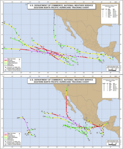
Season summary map |
| First storm formed: |
June 1, 1997 |
| Last storm dissipated: |
December 21, 1997 (record) |
| Strongest storm: |
Linda - 902 mbar (902 hpa) (record), 160 knots (300 km/h) (record) |
| Total storms: |
19 |
| Major storms ( Cat. 3+): |
7 |
| Total damage: |
>$7.6 billion (1997 USD)(record) |
| Total fatalities: |
256-426 direct |
|
|
Pacific hurricane seasons
1995, 1996, 1997, 1998, 1999 |
|
|
The 1997 Pacific hurricane season was an annual event in tropical cyclone meteorology. It was one of the most active seasons. With hundreds of deaths and billions of dollars in damage, this season was the costliest and one of the deadliest Pacific hurricane seasons.
Hurricanes Linda, Pauline, and Nora were the most notable storms in 1997. Linda became the most intense east Pacific hurricane in recorded history. Hurricane Pauline killed several hundred people in Mexico due to heavy flooding, while Hurricane Nora caused flooding and damage in the Southwestern United States. In addition, Super Typhoons Oliwa and Paka originated in region before crossing the International Date Line and causing significant damage in the western Pacific.
Season summary
| Saffir-Simpson Hurricane Scale |
| TD |
TS |
1 |
2 |
3 |
4 |
5 |
The 1997 Pacific hurricane season officially started on May 15, 1997 in the eastern Pacific, and on June 1, 1997 in the central Pacific, and lasted until November 30, 1997. These dates conventionally delimit the period of each year when most tropical cyclones form in the northeastern Pacific Ocean. This season exceeded these boundaries appreciably, as Tropical Storm Paka formed December 2, and dissipated nineteen days later after moving into the Western Pacific.
The 1997 Pacific hurricane season was fairly active, due to the strong El Niño that was occurring at the time. El Niño causes wind shear to be reduced and water temperatures to increase, resulting in conditions more favourable for tropical cyclones in the East Pacific.
There were 24 cyclones in total, including five unnamed tropical depressions. Of these, 19 were in the east Pacific (east of 140° W). Of these, eight peaked at tropical storm intensity, while ten reached hurricane status. Seven of these reached Category 3 intensity or higher on the Saffir-Simpson hurricane scale, including Super Typhoons Oliwa and Paka, which became typhoons after crossing into the western Pacific.
Activity in the central Pacific was also above average. Two tropical storms formed, as did several tropical depressions. A number of storms moved in from the east. With a total of nine tropical cyclones entering or forming there, this was the fourth highest number since satellite observations began.
The first storm formed on June 1. The last storm dissipated December 21, which gives this season the latest known end. However, if December 6, the date the last storm crossed the dateline is taken to be the end, this season has the second latest end, behind the 1983 season and tied with 1957 season.
Storms
Tropical Storm Andres
|
|
|
|
| Duration |
June 2, 1997 – June 7, 1997 |
| Intensity |
50 mph (85 km/h), 998 mbar ( hPa) |
Andres originated as a disturbance that had slowly organized formed into Tropical Depression One-E on June 1. The next day, it reached tropical storm status. After a brief period of a normal track to the northwest, Andres was picked up by westerly winds and became the first named storm to threaten Central America. Initially forecast to cross the isthmus and enter the Caribbean Sea, Andres instead turned to the southeast and paralleled the coast. This was the first time since record-keeping began that any East Pacific storm had taken such a path. Andres then turned back to the northeast. It weakened to a depression and made landfall near San Salvador on June 7 and dissipated shortly thereafter.
Among the casualties were two fishers who were reported missing. Power outages, flooding rivers, several car crashes, and damage to roughly ten homes was attributed to Andres. The highest rainfall report from Mexico was 11.42 inches (290 mm) at Mazatan. Damage was noted in parts of Nicaragua. Andres also killed four people in the Usulatan province due to heavy flooding.
Tropical Storm Blanca
|
|
|
|
| Duration |
June 9, 1997 – June 12, 1997 |
| Intensity |
45 mph (75 km/h), 1002 mbar ( hPa) |
Blanca was a short-lived tropical storm that briefly threatened land. Tropical Depression Two-E formed June 9 and strengthened into Tropical Storm Blanca six hours later. It moved northwest and briefly threatened land on June 10 as warnings and watches were established by the Servicio Meteorológico Nacional. Then, a ridge of high pressure turned Blanca away from the coast.
Despite moving over warm waters, a weakening trend unexpectedly began, and Blanca was downgraded to a depression. and Blanca lost its circulation shortly after being downgraded on June 12.
Rains from Blanca were significant. There was no damage or casualties as Blanca's impact was generally minimal.
Tropical Storm Carlos
|
|
|
|
| Duration |
June 25, 1997 – June 28, 1997 |
| Intensity |
50 mph (85 km/h), 996 mbar ( hPa) |
On June 25, a tropical wave that drifted in from the Atlantic became a tropical depression and that same day developed into Tropical Storm Carlos. As it moved west, Carlos encountered shearing winds and cooler waters and lost its tropical storm status after barely a day, and finally dissipated June 28. Except for Socorro Island, which the system passed close to, Carlos never threatened land.
Hurricane Dolores
|
|
|
|
| Duration |
July 6, 1997 – July 12, 1997 |
| Intensity |
95 mph (150 km/h), 975 mbar ( hPa) |
Dolores began as Tropical Depression Six-E, forming late on July 5 and reaching tropical storm status the following day. Moving westward, Dolores strengthened into the first hurricane of the season on July 7. It reached a peak windspeed of 80 knots (150 km/h). Dolores then became the first hurricane in over two years to cross the 125° W meridian. The storm then started losing strength. Dolores dropped down to a depression on July 11 and dissipated late the next day after crossing into the Central Pacific Hurricane Centre's area of responsibility. The hurricane was not a threat to any land.
Hurricane Enrique
|
|
|
|
| Duration |
July 12, 1997 – July 16, 1997 |
| Intensity |
115 mph (185 km/h), 960 mbar ( hPa) |
Enrique was the first major hurricane of the season. It originated on July 12 when a tropical depression formed. It strengthened into a tropical storm twelve hours later, and became a hurricane on July 13. Enrique began fluctuating in intensity and reached its peak intensity of 100 knots (190 km/h) and 960 mbar (960 hPa) on July 14. Enrique then began to weaken, and dissipated over cooler waters on July 16. Enrique never threatened land.
Hurricane Felicia
|
|
|
|
| Duration |
July 14, 1997 – July 22, 1997 |
| Intensity |
135 mph (215 km/h), 948 mbar ( hPa) |
Tropical Depression Eight-E, the storm that would become Felicia, formed south of the Mexican port of Manzanillo, Colima, on July 13. Its development was delayed by wind shear due to its proximity to Enrique. It became a tropical storm late July 15 as it moved west-northwestward. It became a hurricane July 17. Its development was again stalled by shear. After the shear let up, Felicia’s winds reached 115 knots (215 km/h) and its pressure fell to 948 mbar (948 hPa), making it the second major hurricane of the season. Felicia then began weakening. Shortly before being downgraded to a tropical storm, it crossed 140° W. Felicia was sheared and dissipated July 22, having never threatened land.
Hurricane Guillermo
|
|
|
|
| Duration |
July 30, 1997 – August 24, 1997
(extratropical after August 15) |
| Intensity |
160 mph (260 km/h), 919 mbar ( hPa) |
A tropical wave that drifted across the shear-ridden Atlantic emerged into the Pacific Ocean on July 27. It organized into a depression July 30 and was named Tropical Storm Guillermo the next day. It quickly intensified, reaching hurricane status on August 1. Guillermo became a major hurricane August 2. It reached Category 4 intensity on August 3 before weakening slightly and restrengthening. The hurricane attained Category 5 strength August 4. Guillermo's peak intensity was 919 mbar (919 hPa) and 140 knots (260 km/h).
Guillermo then weakened slowly, becoming a tropical storm August 8. It crossed 140° W and entered the Central Pacific. It weakened to a depression late August 10 but restrengthened back into a storm 24 hours later when it encountered a small area of warm water. It weakened to a depression for the second and final time August 15 and lost tropical characteristics early the next day.
Guillermo's remnants recurved over the far northern Pacific. They were tracked to a point 500 nautical miles (930 km) west of Vancouver Island. The remnants hung on for a few more days and drifted south before being absorbed by a mid-latitude cyclone August 24 off the coast of California.
Tropical Storm Hilda
|
|
|
|
| Duration |
August 10, 1997 – August 15, 1997 |
| Intensity |
50 mph (85 km/h), 1000 mbar ( hPa) |
A tropical wave that had showed hints of development emerged into the East Pacific and organized into Tropical Depression Ten-E on August 10. Its development was inhibited by shear from a large mid-latitude cyclone. The depression managed to become a tropical storm late on August 11. Hilda was a tropical storm for less than three days. Shear weakened Hilda to a depression August 14 and destroyed the cyclone early on August 15. Hilda was no threat to land.
Tropical Storm Ignacio
|
|
Tropical Storm Ignacio |
TS |
|
|
|
| Duration |
August 17, 1997 – August 20, 1997
(extratropical after August 19) |
| Intensity |
40 mph (65 km/h), 1005 mbar ( hPa) |
Tropical Storm Ignacio formed first as a depression in an area of disturbed weather on August 17. 12 hours later, it organized into a tropical storm. Ignacio's location of tropical cyclogenesis was further north and west of where most East Pacific tropical cyclones form. Steering currents pulled Ignacio north, where it encountered wind shear and cooler waters. Ignacio lost tropical characteristics August 19. The remnants moved north, bringing gusty winds to California coastal waters before dissipating. They were then absorbed by the same cyclone that absorbed the remnants of Hurricane Guillermo. It caused rainfall as far north as the U.S. state of Washington.
Hurricane Jimena
|
|
|
|
| Duration |
August 26, 1997 – August 30, 1997 |
| Intensity |
140 mph (225 km/h), 942 mbar ( hPa) |
The next hurricane of the season, Jimena, had a very rapid intensification and an equally rapid decay. Tropical Depression Twelve-E formed August 25 from an area of disturbed weather in a rather easterly location. It became a tropical storm the next day and a hurricane on August 27. Intensification was rapid, with winds increasing from 65 to 115 knots (120 to 215 km/h) in the space of 12 to 15 hours.
It moved north-northwest and encountered an upper level trough. This caused very heavy wind shear which reduced its winds from 115 to 30 knots (215 to 60 km/h) in the space of a day. Jimena completely dissipated on August 30, not long after entering the Central Pacific. Hurricane Jimena was of no threat to land.
Tropical Storm Oliwa
|
|
|
|
| Duration |
September 2, 1997 – September 17, 1997
(in Western Pacific after September 3) |
| Intensity |
50 mph (85 km/h), Pressure unknown (CPAC peak) |
Super Typhoon Oliwa began as a tropical disturbance that had meandered south of Johnston Atoll organized into Tropical Depression Two-C on September 2. Later that day, it was upgraded to Tropical Storm Oliwa ( Hawaiian for Oliver) as it slowly moved towards the west. It crossed the dateline late on September 3 and entered the Joint Typhoon Warning Centre's Area of Responsibility. In the Pacific Ocean, tropical cyclones are not renamed when they cross basin boundaries, so Oliwa kept its name.
Oliwa passed south of Wake on September 6, where it caused heavy rains but no damage. On September 7, Oliwa started a period of rapid strengthening, becoming a typhoon on September 8 and a Super Typhoon eight hours later. Oliwa stayed at that intensity for over two days. While still a strong super typhoon, Oliwa passed near the Northern Marianas Islands. It then started weakening as it curved towards Japan. It made landfall as a minimal typhoon September 16. It quickly dissipated later that same day. Oliwa caused "damage and several fatalities" in Japan.
Tropical Storm Kevin
|
|
|
|
| Duration |
September 3, 1997 – September 7, 1997 |
| Intensity |
60 mph (95 km/h), 994 mbar ( hPa) |
Tropical Storm Kevin, first displayed hints of development while crossing the Atlantic Ocean, and soon developed enough circulation to be a depression in the Pacific on September 3. It became a tropical storm on the morning of September 4. The environment was unfavourable, and two days later, Kevin weakened to a depression when deep convection ceased. It dissipated early on September 7, having never posed a threat to land.
Hurricane Linda
|
|
|
|
| Duration |
September 9, 1997 – September 17, 1997 |
| Intensity |
185 mph (300 km/h), 902 mbar ( hPa) |
Hurricane Linda became the most powerful East Pacific hurricane ever observed when, on September 12, it reached a maximum windspeed of 160 knots (300 km/h) and a minimum pressure of 902 mbar (902 hPa).
Linda had no effect on any land, other than Socorro Island. However, early forecasts predicted that Linda would make landfall in California. The landfall never materialized, and Linda dissipated early September 18 while far out to sea. Warnings or watches were not necessary for any location.
Tropical Storm Marty
|
|
|
|
| Duration |
September 12, 1997 – September 16, 1997 |
| Intensity |
45 mph (75 km/h), 1002 mbar ( hPa) |
Marty was a weak and short-lived tropical cyclone. Two tropical waves contributed to an area of disturbed weather that organized into Tropical Depression Fifteen-E late on September 12. Moving glacially in a westward direction, it strengthened into a tropical storm in the morning of September 14. Marty's forward speed slowed even more, and it turned to the south. It then encountered an unfavourable environment, and shear destroyed the cyclone late on September 16.
Hurricane Nora
|
|
|
|
| Duration |
September 16, 1997 – September 26, 1997 |
| Intensity |
135 mph (215 km/h), 950 mbar ( hPa) |
Hurricane Nora was the first Pacific hurricane to bring gale-force winds to the Continental United States since Kathleen in 1976. A tropical wave organized into Tropical Depression Sixteen-E on September 16 quickly strengthened into a tropical storm. Nora eventually peaked at Category 4. It then encountered water temperature anomalies, and fluctuated in strength. Then, a trough pulled Nora northward and accelerated the storm. After weakening to a Category 1, Nora made landfall in northern Baja California and stayed a tropical storm as it entered the United States. It dissipated over Arizona, but its remnants kept going north.
Rains were heavy, and damage amounted to "several hundred million dollars" in the United States. Several hundred people were rendered homeless, and there was wind and flood damage in Arizona. Nora killed two people in Mexico, and several indirect deaths were reported in California.
Tropical Storm Olaf
|
|
|
|
| Duration |
September 26, 1997 – October 12, 1997 |
| Intensity |
70 mph (110 km/h), 989 mbar ( hPa) |
Tropical Storm Olaf was a weak but persistent tropical storm that made two landfalls and took an erratic path. A tropical depression formed September 26, was upgraded a tropical storm at the next advisory. The cyclone immediately moved north. Instead of strengthening into a hurricane as forecast, Olaf unexpectedly weakened. On September 29, Olaf made landfall near Salina Cruz, Oaxaca.
Olaf, as a tropical depression, moved westward, far out to sea. Restrengthening, Olaf moved southeast on October 5 due to the influence of Hurricane Pauline. Olaf then turned north, and on October 12 made a second landfall near Manzanillo, Colima, as a tropical depression. Olaf's surface circulation weakened, and its remnants moved back out to sea, not to return.
Olaf resulted in some reports of damage and flooding in Mexico and Guatemala. Several people were reported missing. All of its damage was from its first landfall. Throughout Southern Mexico, Guatemala and El Salvador, flooding caused by Olaf was blamed for eighteen deaths.
Hurricane Pauline


