Amazon Rainforest
2008/9 Schools Wikipedia Selection. Related subjects: Central & South American Geography
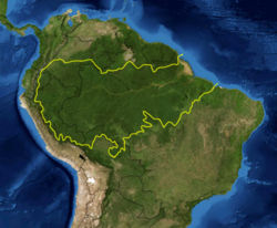
The Amazon Rainforest (Brazilian Portuguese: Floresta Amazônica or Amazônia; Spanish: Selva Amazónica or Amazonía) is a moist broadleaf forest in the Amazon Basin of South America. The area, also known as Amazonia, the Amazon jungle or the Amazon Basin, encompasses seven million square kilometers (1.7 billion acres), though the forest itself occupies some 5.5 million square kilometers (1.4 billion acres), located within nine nations: Brazil (with 60 percent of the rainforest), Peru (with 13 percent of the rainforest, second after Brazil), Colombia, Venezuela, Ecuador, Bolivia, Guyana, Suriname, and French Guiana. States or departments in four nations bear the name Amazonas after it. The Amazon represents over half of the planet's remaining rainforests and comprises the largest and most species-rich tract of tropical rainforest in the world.
Etymology
The name Amazon is said to arise from a war which Francisco de Orellana had with a tribe of Tapuyas and other tribes from South America where the women of the tribe fought alongside the men, as was the custom among the entire tribe. (Orellana's descriptions may have been accurate, but a few historians speculate that Orellana could have been mistaking indigenous men wearing "grass skirts" for women.) Orellana derived the name Amazonas from the ancient Amazons of Asia and Africa described by Herodotus and Diodorus in Greek legends.
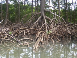
Another etymology for the word suggests that it came originally from a native word amazona (Spanish spelling) or amassona (Portuguese spelling), meaning "destroyer (of) boats", in reference to the destructive nature of the root system possessed by some riparian plants.
Biodiversity
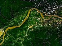
Wet tropical forests are the most species-rich biome, and tropical forests in the Americas are consistently more species rich than the wet forests in Africa and Asia. As the largest tract of tropical rainforest in the Americas, the Amazonian rainforests have unparalleled biodiversity. One in ten known species in the world live in the Amazon Rainforest.
The region is home to about 2.5 million insect species, tens of thousands of plants, and some 2000 birds and mammals. To date, at least 40,000 plant species, 3,000 fish, 1,294 birds, 427 mammals, 428 amphibians, and 378 reptiles have been scientifically classified in the region. Scientists have described between 96,660 and 128,843 invertebrate species in Brazil alone.
The diversity of plant species is the highest on earth with some experts estimating that one square kilometer may contain over 75,000 types of trees and 150,000 species of higher plants. One square kilometer of Amazon rainforest can contain about 90,790 tonnes of living plants. This constitutes the largest collection of living plants and animal species in the world. One in five of all the birds in the world live in the rainforests of the Amazon. To date, an estimated 438,000 species of plants of economic and social interest have been registered in the region with many more remaining to be discovered or catalogued.
Deforestation
Deforestation is the conversion of forested areas to non-forested areas. The main sources of deforestation in the Amazon are human settlement and development of the land. Between 1991 and 2000, the total area of forest lost in the Amazon rose from 415,000 to 587,000 km², an area more than six times the size of Portugal, with most of the lost forest becoming pasture for cattle. In February, 2008, the Brazilian government announced that the rate at which the Amazon rainforest is being cut down has increased significantly over the past few months. During the last five months of 2007, more than 3,200 sq. kilometers (an area equivalent to the size of the state of Rhode Island) was deforested during a time when deforestation would normally drop.
History of deforestation in the Amazon
Prior to the early 1960s, access to the forest's interior was highly restricted, and aside from partial clearing along rivers the forest remained basically intact. The poor soil also made plantation-based agriculture unprofitable. The key point in deforestation of the Amazon was when colonists established farms within the forest during the 1960s. Their farming system was based on crop cultivation and the slash and burn method. However, the colonists were unable to successfully manage their fields and the crops due to the loss of soil fertility and weed invasion. The soils in the Amazon are productive for just a short period of time, and farmers are therefore constantly moving to new areas and clearing more and more land. Amazonian colonization was ruled by cattle raising because ranching required little labor, generated decent profits, and awarded social status in the community. Additionally, grass can grow in the poor Amazon soil. However, the results of the farming lead to extensive deforestation and caused extensive environmental damage. An estimated 30% of the deforestation is due to small farmers and the intensity within the area that they inhabit is greater than the area occupied by the medium and large ranchers who possess 89% of the Legal Amazon’s private land. This emphasizes the importance of using previously cleared land for agricultural use, rather the typical easiest political path of distributing still-forested areas. In the Brazilian Amazon, the amount of small farmers versus large landholders changes frequently with economic and demographic pressures.
Causes of deforestation in the Amazon
The annual rate of deforestation in the Amazon region has continued to increase from 1990 to 2003 because of factors at local, national, and international levels. 70% of formerly forested land in the Amazon, and 91% of land deforested since 1970, is used for livestock pasture. In addition, Brazil is currently the second-largest global producer of soybeans after the United States, mostly for livestock feed, and as prices for soybeans rise, the soy farmers are pushing northwards into forested areas of the Amazon. As stated in Brazilian legislation, clearing land for crops or fields is considered an ‘effective use’ of land and is the beginning towards land ownership. Cleared property is also valued 5–10 times more than forested land and for that reason valuable to the owner whose ultimate objective is resale. As stated by Michael Williams,“The people of Brazil have always thought of the Amazon as a communal possession which they felt free to hack, burn, and abandon at will.” The soy industry is the principal source of foreign currency for Brazil; therefore, the needs of soy farmers have been used to validate many of the controversial transportation projects that are currently developing in the Amazon. The first two highways: the Belém-Brasília (1958) and the Cuiaba-Porto Velho (1968) were the only federal highways in the Legal Amazon to be paved and passable year-round before the late 1990’s. These two highways are said to be “at the heart of the ‘arc of deforestation’”, which at present is the focal point area of deforestation in the Brazilian Amazon. The Belém-Brasilia highway attracted nearly two million settlers in the first twenty years. The success of the Belém-Brasilia highway in opening up the forest was re-enacted as paved roads continued to be developed unleashing the irrepressible spread of settlement. The completions of the roads were followed by a wave of resettlement and the settlers had a significant effect on the forest.
Scientists using NASA satellite data have found that clearing for mechanized cropland has recently become a significant force in Brazilian Amazon deforestation. This change in land use may alter the region's climate and the land's ability to absorb carbon dioxide. Researchers found that in 2003, the then peak year of deforestation, more than 20 percent of the Mato Grosso state’s forests were converted to cropland. This finding suggests that the recent cropland expansion in the region is contributing to further deforestation. In 2005, soybean prices fell by more than 25 percent and some areas of Mato Grosso showed a decrease in large deforestation events, although the central agricultural zone continued to clear forests. But, deforestation rates could return to the high levels seen in 2003 as soybean and other crop prices begin to rebound in international markets. Brazil has become a leading worldwide producer of grains including soybean, accounting for more than one-third of the country's gross national product. This new driver of forest loss suggests that the rise and fall of prices for other crops, beef and timber may also have a significant impact on future land use in the region, according to the study.
Measured rates of deforestation in the Amazon
In 1996, the Amazon was reported to have shown a 34% increase in deforestation since 1992. The mean annual deforestation rate from 2000 to 2005 (22,392 km² per year) was 18% higher than in the previous five years (19,018 km² per year). In Brazil, the Instituto Nacional de Pesquisas Espaciais (INPE, or National Institute of Space Research) produces deforestation figures annually. Their deforestation estimates are derived from 100 to 220 images taken during the dry season in the Amazon by the Landsat satellite, also may only consider the loss of the Amazon rainforest biome – not the loss of natural fields or savannah within the rainforest. According to INPE, the original Amazon rainforest biome in Brazil of 4,100,000 km² was reduced to 3,403,000 km² by 2005 – representing a loss of 17.1%.
| Period | Estimated Remaining Forest Cover in the Brazilian Amazon (km²) |
Annual forest loss (km²) |
Percent of 1970 cover remaining |
Total forest loss since 1970 (km²) |
|---|---|---|---|---|
| pre-1970 | 4,100,000 | 0 | 100% | |
| 1977 | 3,955,870 | 21,130 | 96.50% | 144,130 |
| 1978-1987 | 3,744,570 | 21,130 | 91.30% | 355,430 |
| 1988 | 3,723,520 | 21,050 | 90.80% | 376,480 |
| 1989 | 3,705,750 | 17,770 | 90.40% | 394,250 |
| 1990 | 3,692,020 | 13,730 | 90.00% | 407,980 |
| 1991 | 3,680,990 | 11,030 | 89.80% | 419,010 |
| 1992 | 3,667,204 | 13,786 | 89.40% | 432,796 |
| 1993 | 3,652,308 | 14,896 | 89.10% | 447,692 |
| 1994 | 3,637,412 | 14,896 | 88.70% | 462,588 |
| 1995 | 3,608,353 | 29,059 | 88.00% | 491,647 |
| 1996 | 3,590,192 | 18,161 | 87.60% | 509,808 |
| 1997 | 3,576,965 | 13,227 | 87.20% | 523,035 |
| 1998 | 3,559,582 | 17,383 | 86.80% | 540,418 |
| 1999 | 3,542,323 | 17,259 | 86.40% | 557,677 |
| 2000 | 3,524,097 | 18,226 | 86.00% | 575,903 |
| 2001 | 3,505,932 | 18,165 | 85.50% | 594,068 |
| 2002 | 3,484,727 | 21,205 | 85.00% | 615,273 |
| 2003 | 3,459,576 | 25,151 | 84.40% | 640,424 |
| 2004 | 3,432,147 | 27,429 | 83.70% | 667,853 |
| 2005 | 3,413,354 | 18,793 | 83.30% | 686,646 |
| 2006 | 3,400,254 | 13,100 | 82.90% | 699,746 |
Future of deforestation
At the current rate, in two decades the Amazon Rainforest will be reduced by 40%. The 2005-2006 year had a 41% drop in deforestation. This was the lowest figure since 1991. However, in February 2008, the Peruvian Congress plans to debate a draft law ("Ley de la Selva") that would allow the sale of vast tracts of deforested, uncultivated land in the Amazon jungle to private companies. However, there is no land registry showing which natural areas could be sold off without hurting the region’s rich biodiversity. Moreover, the sale of public lands would adversely affect local residents who do not hold formal title to their land.
Links to main causes for deforestation
- Slash and burn agriculture
- Construction of the Trans-Amazonian Highway
- Logging
- Cattle ranching
- Hydro-electric dam
Carbon dynamics
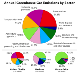
Not only are environmentalists concerned about the loss of biodiversity which will result from destruction of the forest, they are also concerned about the release of the carbon contained within the vegetation, which could accelerate global warming.
Amazonian evergreen forests account for about 10% of the world's terrestrial primary productivity and 10% of the carbon stores in ecosystems — of the order of 1.1 x 10¹¹ metric tonnes of carbon. Amazonian forests are estimated to have accumulated 0.62 ± 0.37 tons of carbon per hectare per year between 1975 and 1996. Fires related to Amazonian deforestation have made Brazil one of the top greenhouse gas producers. Brazil produces about 300 million metric tonnes of carbon dioxide a year; 200 million of these come from logging and burning in the Amazon. Despite this, Brazil is listed as one of the lowest per capita (rank 124) in CO2 emissions according to the US Department of Energy's Carbon Dioxide Information Analysis Centre (CDIAC) (see List of countries by carbon dioxide emissions per capita).
Conservation
Environmentalists have stated there is not only a biological incentive to protecting the rainforest, but also an economic one. One hectare in the Peruvian Amazon has been calculated to have a value of $6820 if intact forest is sustainably harvested for fruits, latex, and timber; $1000 if clear-cut for commercial timber (not sustainably harvested); or $148 if used as cattle pasture.
The Brazilian Air Force has been using Embraer R-99 surveillance aircraft, as part of the SIVAM program, to monitor the forest. At a conference in July 2004, scientists warned that the rainforest will no longer be able to absorb the millions of tons of greenhouse gases annually, as it usually does, because of the increased pace of rainforest destruction, and the increase in the greenhouse gases emission by industrialized countries. 9,169 square miles (23,750 km²) of rain forest were cut down in 2003 alone.
In Brazil alone, more than 90 indigenous groups have been destroyed by epidemics and Brazilian colonists since the 1900s, and with them have gone centuries of accumulated knowledge of the value of rainforest species. As indigenous territories continue to be destroyed by deforestation, and ecocide, such as in the Peruvian Amazon indigenous peoples' rainforest communities continue to disappear, while others, like the Urarina continue to struggle to fight for their cultural survival and the fate of their forested territories. Meanwhile, the relationship between nonhuman primates in the subsistence and symbolism of indigenous lowland South American peoples has gained increased attention, as has ethno-biology and community-based conservation efforts.
From 2002 to 2006, the conserved land in the Amazon Rainforest has almost tripled and deforestation rates have dropped up to 60%. About 1,000,000 square kilometres (250,000,000 acres) have been put onto some sort of conservation, which adds up to a current amount of 1,730,000 square kilometres (430,000,000 acres).
Remote sensing and the Amazon
The use of remotely sensed data is dramatically improving conservationists' knowledge of the Amazon Basin. Given the objectivity and lowered costs of satellite-based land cover analysis, it appears likely that remote sensing technology will be an integral part of assessing the extent and damage of deforestation in the basin. Furthermore, remote sensing is the best and perhaps only possible way to study the Amazon on a large-scale.
The use of remote sensing for the conservation of the Amazon is also being used by the indigenous tribes of the basin to protect their tribal lands from commercial interests. Using handheld GPS devices and programs like Google Earth, members of the Trio Tribe, who live in the rainforests of southern Suriname, map out their ancestral lands to help strengthen their territorial claims. Currently, most tribes in the Amazon do not have clearly defined boundaries, which make their territories easy targets for commercial poaching of natural resources. Through the use of cheap mapping technology, the Trio Tribe hopes to protect its ancestral land.
In order to accurately map the biomass of the Amazon, and subsequent carbon related emissions, the classification of tree growth stages within different parts of the forest are crucial. In 2006 Tatiana Kuplich organized the trees of the Amazon into four categories: (1) mature forest; (2) regenerating forest [less than three years]; (3) regenerating forest [between three and five years of regrowth]; (4) regenerating forest [eleven to eighteen years of continued development]. The researcher used a combination of Synthetic Aperture Radar (SAR) and Thematic Mapper (TM) to accurately place the different portions of the Amazon into one of the four classifications.
Response to climate change
There is evidence that there have been significant changes in Amazon rainforest vegetation over the last 21,000 years through the last glaciation (LGM) and subsequent deglaciation. Analyses of sediment deposits from Amazon basin paleolakes and from the Amazon Fan indicate that rainfall in the basin during the LGM was lower than for the present, and this was almost certainly associated with reduced moist tropical vegetation cover in the basin. There is debate, however, over how extensive this reduction was. Some scientists argue that the rainforest was reduced to small, isolated refugia separated by open forest and grassland; other scientists argue that the rainforest remained largely intact but extending less far to the North, South and East than is seen today . This debate has proved difficult to resolve because the practical limitations of working in the rainforest mean that data sampling is biased away from the centre of the Amazon basin, and both explanations are reasonably well supported by the available data.
One computer model of future climate change due to greenhouse gas emissions shows that the Amazon rainforest could become unsustainable under conditions of severely reduced rainfall and increased temperatures, leading to an almost complete loss of rainforest cover in the basin by 2100. However, simulations of Amazon basin climate change across many different models are not consistent in their estimation of any rainfall response, ranging from weak increases to strong decreases. The result indicates that the rainforest could be threatened though the 21st century by climate change in addition to deforestation.
Impact of Amazon drought
In 2005, parts of the Amazon basin experienced the worst drought in 100 years, and there were indications that 2006 could have been a second successive year of drought. A 23 July 2006 article in the UK newspaper The Independent reported Woods Hole Research Centre results showing that the forest in its present form could survive only three years of drought. Scientists at the Brazilian National Institute of Amazonian Research argue in the article that this drought response, coupled with the effects of deforestation on regional climate, are pushing the rainforest towards a " tipping point" where it would irreversibly start to die. It concludes that the forest is on the brink of being turned into savanna or desert, with catastrophic consequences for the world's climate.
According to the WWF, the combination of climate change and deforestation increases the drying effect of dead trees that fuels forest fires.
Territory contest
Some politicians and journalists believe that the Amazon is an international area and belongs to all humanity. Al Gore said in 1989: "Contrary to what Brazilians think, the Amazon is not their property, it belongs to all of us." There is much controversy on this in Brazilian press, government and society suggesting this argument hurts the nation's sovereignty.
In May 2008, The New York Times wrote an article titled Whose Rain Forest Is This, Anyway? . The article was received controversially in Brazil forcing the President Lula to answer "the Amazon belongs to Brazilians," and later with more aggressive response: "North Americans have no moral authority to complain about Amazonia, they point fingers dirty with oil."
There is a debate in Brazilian society if the Amazon could be invaded resulting in a war. The Brazilian Amazon border is patrolled and guarded by the Brazilian Army.
Video
- Documentary: About Tristes Tropiques
- Documentary: War of Pacification in Amazonia
