Ben Nevis
2008/9 Schools Wikipedia Selection. Related subjects: Geography of Great Britain
| Ben Nevis | |
|---|---|
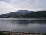
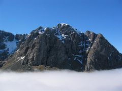
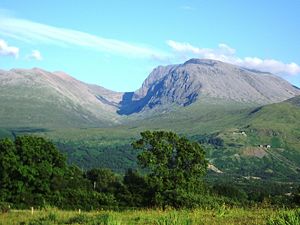 Ben Nevis from Banavie. The summit is beyond and to the left of the apparent highest point. |
|
| Elevation | 1,344 metres (4,409 ft) |
| Location | Lochaber, Scotland |
| Prominence | 1,344 m Ranked 1st in British Isles |
| Parent peak | none - HP Great Britain |
| Coordinates | |
| Topo map | OS Landranger 41, Explorer 392 |
| First ascent | 17 August 1771, by James Robertson |
| Easiest route | Walk |
| OS grid reference | NN166713 |
| Listing | Munro, Marilyn, Council top ( Highland), County top ( Inverness-shire) |
| Translation | Venomous mountain or mountain with its head in the clouds ( Scottish Gaelic language) |
Ben Nevis ( Gaelic: Beinn Nibheis, pronounced [peˈɲivəʃ]) is the highest mountain in the British Isles. It is located at the western end of the Grampian Mountains in the Lochaber area of Scotland, close to the town of Fort William.
In common with many other Scottish mountains, it is known to locals as simply The Ben. However, if walkers and climbers from outside Scotland use the term "The Ben" they usually mean Ben Nevis. It attracts an estimated 100,000 ascents a year, around three-quarters of which are made using the well-constructed Pony Track from Glen Nevis on the south side of the mountain. For climbers and mountaineers the main attraction lies in the 700-metre-high cliffs of the north face: among the highest cliffs in Britain, they harbour some classic scrambles and rock climbs of all difficulties, and are one of the principal locations in the UK for ice climbing.
The summit, at 1,344 metres (4,406 ft) above sea level, features the ruins of an observatory which was permanently staffed between 1883 and 1904. The meteorological data collected during this period is still important for an understanding of Scottish mountain weather. C. T. R. Wilson was inspired to invent the cloud chamber after a period spent working at the observatory.
Geography
Ben Nevis forms a massif with its neighbour to the north-east, Carn Mòr Dearg, to which it is linked by the Carn Mòr Dearg Arête. Both mountains are among the eight in Great Britain over 4,000 feet (1,219 metres), as are Aonach Mòr and Aonach Beag immediately to the east; the other four are all in the Cairngorms.
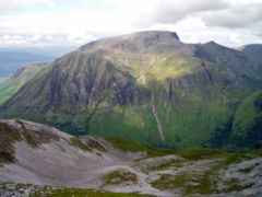
The western and southern flanks of Ben Nevis rise 1,200 metres in around 2 km from the floor of Glen Nevis—the longest and steepest hill slope in Britain—with the result that the mountain presents an aspect of massive bulk on this side. To the north, in contrast, cliffs drop some 600 metres (2,000 ft) to Coire Leis. This corrie contains the Charles Inglis Clark Memorial Hut (known as the CIC Hut), a private mountain hut located at 680 metres above sea level, owned by the Scottish Mountaineering Club and used as a base for the many climbing routes on the mountain's north face.
In addition to the main 1,344-metre summit, Ben Nevis has two subsidiary "tops" listed in Munro's Tables, both of which are called Carn Dearg ("red hill"). The higher of these, at 1,221 metres, is situated to the north-west, and is often mistaken for Ben Nevis itself in views from the Fort William area. The other Carn Dearg (1,020 m) juts out into Glen Nevis on the mountain's south-western side. A lower hill, Meall an t-Suidhe (711 m), is located further west, forming a saddle with Ben Nevis which contains a small loch, Lochan an t-Suidhe. The popular tourist path from Glen Nevis skirts the side of this hill before ascending Ben Nevis's broad western flank.
Geology
Ben Nevis consists mainly of igneous rock from the Devonian period (around 400 million years ago), intruded into the surrounding metamorphic schists; the intrusions take the form of a series of concentric ring dikes. The innermost of these, known as the Inner Granite, constitutes the southern bulk of the mountain above Lochan Meall an t-Suidhe, and also the neighbouring ridge of Carn Mòr Dearg; Meall an t-Suidhe forms part of the Outer Granite, which is redder in colour. The summit dome itself, together with the steep northern cliffs, are composed of andesite and basaltic lavas. The mountain has been extensively shaped by glaciation.
Climate
Ben Nevis's altitude, maritime location and topography frequently lead to unusually poor weather conditions, which can pose a danger to ill-equipped walkers. According to the observations carried out at the summit observatory from 1883–1904, fog was present on the summit for almost 80% of the time between November and January, and 55% of the time in May and June. The average winter temperature was around -5 ° C, and the mean monthly temperature for the year was -0.5 °C. In an average year the summit sees 261 gales, and receives 4,350 millimetres (171 inches) of rainfall, compared to only 2,050 mm in nearby Fort William and about 600 mm in Inverness and London. Rainfall on Ben Nevis is about twice as high in the winter as it is in the spring and summer. Snow can be found on the mountain almost all year round, particularly in the gullies of the north face - with the higher reaches of Observatory Gully holding snow until September most years and sometimes until the new snows of the following season.
History
The first recorded ascent of Ben Nevis was made on 17 August 1771 by James Robertson, an Edinburgh botanist, who was in the region to collect botanical specimens. Another early ascent was in 1774 by John Williams, who provided the first account of the mountain's geological structure. John Keats climbed the mountain in 1818, comparing the ascent to "mounting ten St. Pauls without the convenience of a staircase". It was not until 1847 that Ben Nevis was confirmed by the Ordnance Survey as the highest mountain in Britain, ahead of its rival Ben Macdui.
The summit observatory was built in the summer of 1883, and would remain in operation for 21 years. The first path to the summit was built at the same time as the observatory and was designed to allow ponies to carry up supplies, with a maximum gradient of one in five. The opening of the path and the observatory made the ascent of the Ben increasingly popular, all the more so after the arrival of the West Highland Railway in Fort William in 1894. Around this time the first of several proposals was made for a rack railway to the summit, none of which came to fruition.
In 2000 the Ben Nevis Estate, comprising all of the south side of the mountain including the summit, was bought by the Scottish conservation charity the John Muir Trust.
Ascent routes
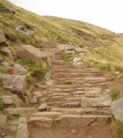
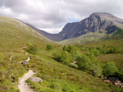
The 1883 Pony Track to the summit (also known as the Ben Path, the Mountain Path, or the Tourist Route) remains the simplest and most popular route of ascent. It begins at Achintee on the east side of Glen Nevis about 2 km (1.5 miles) from Fort William town centre, at around 20 metres above sea level. Bridges from the Visitor Centre and the youth hostel now allow access from the west side of Glen Nevis. The path climbs steeply to the saddle by Lochan Meall an t-Suidhe at 570 m, then ascends the remaining 700 metres up the stony west flank of Ben Nevis in a series of zig-zags. It is well made and maintained throughout its length, and, thanks to the zig-zags, not unusually steep apart from in the initial stages.
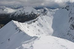
A route popular with experienced hillwalkers starts at Torlundy, a few miles north-east of Fort William on the A82 road, and follows the path alongside the Allt a' Mhuilinn. It can also be reached from Glen Nevis by following the Pony Track as far as Lochan Meall an t-Suidhe, then descending slightly to the CIC Hut. The route then ascends Carn Mòr Dearg and continues along the Carn Mòr Dearg Arête ("CMD Arête") before climbing steeply to the summit of Ben Nevis. This route involves a total of 1,500 metres of ascent and requires modest scrambling ability and a head for heights. In common with other approaches on this side of the mountain, it has the advantage of giving an extensive view of the cliffs of the north face, which are hidden from the Pony Track.
It is also possible to climb Ben Nevis from the Nevis Gorge car park at the head of the road up Glen Nevis, either by the south-east ridge or via the summit of Carn Dearg (south-west). These routes do not require scrambling, but are shorter and steeper, and tend to be used by experienced hill walkers.
The summit
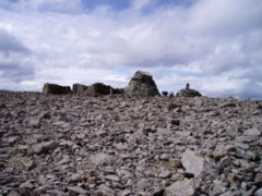
The summit of Ben Nevis comprises a large stony plateau of around 40 hectares (100 acres). The highest point is marked with a large, solidly built cairn atop which sits an Ordnance Survey trig point.
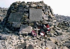
The ruined walls of the observatory are a prominent feature on the summit. An emergency shelter has been built on top of the observatory tower for the benefit of those caught out by bad weather, and, although the base of the tower is slightly lower than the true summit of the mountain, the roof of the shelter overtops the trig point by several feet, making it the highest man-made structure in Britain. A war memorial to the dead of World War II is located next to the observatory.
On 17 May 2006, a piano that had been buried under one of the cairns on the peak was uncovered by the John Muir Trust, which owns much of the mountain. The piano was believed to have been carried up for charity by removal men from Dundee over 20 years earlier.
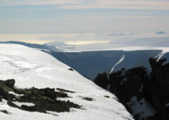
The view from Britain's highest point is extensive. In ideal conditions it can extend up to 190 km (120 miles), including such mountains as the Torridon Hills, Morven in Caithness, Lochnagar, Ben Lomond, Barra Head, and 123 miles (198 km) to Knocklayd in County Antrim, Northern Ireland.
Observatory
A meteorological observatory on the summit was first proposed by the Scottish Meteorological Society (SMS) in the late 1870s, at a time when similar observatories were being built around the world to study the weather at high altitude. In the summer of 1881 Clement Lindley Wragge climbed the mountain daily to make observations (earning the nickname "Inclement Rag"), leading to the opening on 17 October 1883 of a permanent observatory run by the SMS. The building was permanently manned until 1904, when it was closed due to inadequacy of government funding. The twenty years' worth of readings still provide the most comprehensive set of data on mountain weather in Great Britain.
In September 1894, C. T. R. Wilson was employed at the observatory for a couple of weeks as temporary relief for one of the permanent staff. During this period he witnessed a Brocken spectre and glory, caused by the sun casting a shadow on cloud below the observer. He subsequently tried to reproduce these phenomena in the laboratory, resulting in his invention of the cloud chamber used to detect ionising radiation.
Navigation and safety
Ben Nevis's popularity, climate and complex topography contribute to a high number of mountain rescue incidents. In 1999, for example, there were 41 rescues and four fatalities on the mountain. Some accidents arise over difficulties in navigating to or from the summit, especially in poor visibility. The problem stems from the fact that the summit plateau is roughly kidney-shaped, and surrounded by cliffs on three sides; the danger is particularly accentuated when the main path is obscured by snow. Two precise compass bearings taken in succession are necessary to navigate from the summit cairn to the west flank, from where a descent can be made on the Pony Track in relative safety.
In the late 1990s Lochaber Mountain Rescue Team erected two posts on the summit plateau, in order to assist walkers attempting the descent in foggy conditions. These posts were subsequently cut down by climbers, sparking controversy in mountaineering circles on the ethics of such additions. Supporters of navigational aids point to the high number of accidents that occur on the mountain (between 1990 and 1995 alone there were 13 fatalities, although eight of these were due to falls while rock climbing rather than navigational error), the long tradition of placing such aids on the summit, and the potentially life-saving role they could play. However, critics argue that cairns and posts are an unnecessary man-made intrusion into the natural landscape, which create a false sense of security and could lessen mountaineers' sense of responsibility for their own safety.
Climbing on Ben Nevis
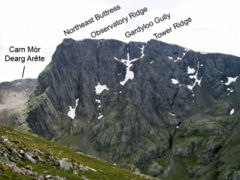
The north face of Ben Nevis is riven with buttresses, ridges, towers and pinnacles, and contains many classic scrambles and rock climbs. It is of major importance for British winter climbing, with many of its routes holding snow often until late April. It was one of the first places in Scotland to receive the attention of serious mountaineers, with a descent of Tower Ridge in 1892 the earliest documented climbing expedition on the Ben. (It was not climbed from bottom to top for another two years.) The Scottish Mountaineering Club's Charles Inglis Clark hut was built below the north face in Coire Leis in 1929. Because of its remote location, it is said to be the only genuine alpine hut in Britain. It remains popular with climbers, especially in winter.
Tower Ridge is the longest of the north face's four main ridges, with around 600 metres of ascent. It is not technically demanding (its grade is Difficult), and most pitches can be tackled unroped by competent climbers, but it is committing and very exposed. Castle Ridge, the first of the main ridges, is an easier scramble, while Observatory Ridge is graded Very Difficult; the latter is the closest ridge to the summit. Between the Tower and Observatory Ridges is Gardyloo Gully, which takes its name from the cry of "garde à l'eau" (French for "watch out for the water"), formerly used in Scottish cities used as a warning when householders threw their slops out of a tenement window into the street. The gully's top wall was the refuse tip for the now-disused summit observatory. The North-east Buttress is the last and bulkiest of these four ridges, and is regarded as the hardest for its combination of technical difficulty and seriousness.
The north face contains dozens of graded rock climbs along its entire length, with particular concentrations on the Carn Dearg Buttress (below the Munro top of Carn Dearg NW) and around the North-east Buttress and Observatory Ridge. Classic rock routes include Rubicon Wall on Observatory Buttress (Severe) – whose second ascent in 1937, when it was considered the hardest route on the mountain, is described by W. H. Murray in Mountaineering in Scotland – and, on Carn Dearg, Centurion (HVS) and Agrippa (E5).
Other classic routes were put up by Dr J. H. B. Bell and others between the Wars; these include Bell's 'Long Climb', at 1,400 ft (430 m) reputedly the longest on the mainland.
The north face is also of Scotland's foremost venues for winter mountaineering and ice climbing, and holds snow until quite late in the year; in a good year routes may remain in winter condition until mid-spring. Most of the possible rock routes are also suitable as winter climbs, including the four main ridges; Tower Ridge, for example, is grade III on the Scottish winter grading system. Probably the most popular ice climb on Ben Nevis is The Curtain (IV,5) on the left side of the Carn Dearg Buttress. At the top end of the scale, Centurion in winter is a grade VIII,8 face climb.
Ben Nevis Race
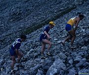
The history of hill running on Ben Nevis dates back to 1895. William Swan, a hairdresser from Fort William, made the first recorded timed ascent up the mountain on or around 27 September of that year, when he ran from the old post office in Fort William to the summit and back in 2 hours 41 minutes. The following years saw several improvements on Swan's record, but the first competitive race was held on 3 June 1898 under Scottish Amateur Athletic Association rules. Ten competitors ran the course, which started at the Lochiel Arms Hotel in Banavie and was thus longer than the route from Fort William; the winner was 21-year-old Hugh Kennedy, a gamekeeper at Tor Castle, who finished (coincidentally with Swan's original run) in 2 hours 41 minutes.
Regular races were organised until 1903, when two events were held; these were the last for 24 years, perhaps due to the closure of the summit observatory the following year. The first was from Achintee, at the foot of the Pony Track, and finished at the summit; It was won in just over an hour by Ewen MacKenzie, the observatory roadman. The second race ran from new Fort William post office, and MacKenzie lowered the record to 2 hours 10 minutes, a record he held for 34 years.
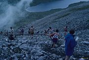
The Ben Nevis Race has been run in its current form since 1937. It now takes place on the first Saturday in September every year, with a maximum of 500 competitors taking part. It starts and finishes at the Claggan Park football ground on the outskirts of Fort William, and is 16 km long with 1,340 m of ascent. Due to the seriousness of the mountain environment, entry is restricted to those who have completed three hill races, and runners must carry waterproofs, a hat, gloves and a whistle; anyone who has not reached the summit after two hours is turned back. As of 2006 the records have stood unbroken since 1984, when Kenny Stuart and Pauline Howarth of Keswick Athletics Club won the men's and the women's races with times of 1:25:34 and 1:43:25 respectively.
Environmental issues
Ben Nevis's popularity and high profile have led to concerns in recent decades over the impact of humans on the fragile mountain environment. These concerns contributed to the purchase of the Ben Nevis Estate in 2000 by the John Muir Trust, a Scottish charity dedicated to the conservation of wild places. The Estate covers 1,700 hectares of land on the south side of Ben Nevis and the neighbouring mountains of Carn Mòr Dearg and Aonach Beag, including the summit of Ben Nevis.
The John Muir Trust is one of nine bodies represented on the main board of the Nevis Partnership. Founded in 2003, the Partnership, which also includes representatives from local government, Glen Nevis residents and mountaineering interests, works to "guide future policies and actions to safeguard, manage and where appropriate enhance the environmental qualities and opportunities for visitor enjoyment and appreciation of the Nevis area". Its projects include path repairs and improvement and the development of strategies for visitor management.
One of the Nevis Partnership's more controversial actions has concerned the large number of memorial plaques placed by individuals, especially around the summit war memorial. Many people believe that the proliferation of such plaques is inappropriate, and in August 2006 the Nevis Partnership declared an intention to eventually remove these plaques (after making efforts to return them to their owners) as part of a wider campaign to clean up the mountain.
In 2005 the amount of litter on the Pony Track was highlighted by national media, including BBC Radio 5 Live. Robin Kevan, a retired social worker from mid-Wales who is known as "Rob the Rubbish" for his efforts to clean up the countryside, then drove to Ben Nevis and cleaned the mountain himself, resulting in much media coverage and a concerted clean-up effort.
Ben Nevis Distillery
The Ben Nevis Distillery is a single malt whisky distillery at the foot of the mountain, located by Victoria Bridge to the north of Fort William. Founded in 1825 by John McDonald (known as "Long John"), it is one of the oldest licensed distilleries in Scotland, and is a popular visitor attraction in Fort William. The water used to make the whisky comes from the Allt a' Mhuilinn, the stream that flows from Ben Nevis's northern corrie. "Ben Nevis" 80/- organic ale is by contrast brewed in Bridge of Allan near Stirling.
Etymology
"Ben Nevis" is an anglicisation of the Gaelic name Beinn Nibheis. While beinn is the most common Gaelic word for "mountain", Nibheis is variously understood, though the name is commonly translated as "malicious" or "venomous mountain". An alternative interpretation is that Beinn Nibheis derives from beinn-neamh-bhathais, from Neamh "heavens, clouds" and bathais "top of a man's head". A literal translation would therefore be "the mountain with its head in the clouds", though "mountain of Heaven" is also frequently given.
