Gaborone
2008/9 Schools Wikipedia Selection. Related subjects: Africa; Cities
| Gaborone | |
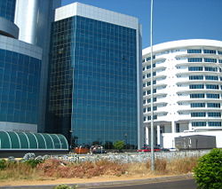
| Modern buildings in Gaborone | |
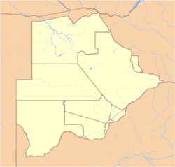
| Location of Gaborone in Botswana | |
| Coordinates: | |
|---|---|
| Country | Botswana |
| District | South-East |
| Elevation | 900 m (2,953 ft) |
| Population ( 1 January 2005) | |
| - Total | 208,411 |
| Time zone | GMT +2 ( UTC) |
Gaborone (pronounced /ˌxɑːbəˈroʊni/, or spelling pronunciation /ˌɡæbəˈroʊni/), estimated population 208,411 ( 1 January 2005), is the capital of Botswana. Gaborone lies in the flat valley between Kgale and Oodi Hills, on the Notwane River in the south eastern corner of Botswana, and 15 kilometers (9 mi) from the South African border. It is the administrative capital of the South-East district.
History
Before 1969, the city was known as Gaberones . Gaberones replaced Mafeking as the capital of the Bechuanaland Protectorate in 1965. Mafeking (now Mafikeng) was outside the Bechuanaland Protectorate, in what is now the North West Province of South Africa, an odd arrangement that dated from the early colonial period. When the Protectorate became independent, Botswana needed a capital city within its territory; earlier it had been thought Lobatse might serve as capital but it was decided that it would be too limited, and instead a new capital city would be created adjacent to Gaberones, a small colonial administrative settlement. The original name, Gaberones, is from Gaborone's Village, following the early practice of referring to African tribal capitals by the name of the chief, in this case Chief Kgosi Gaborone of the BaTlokwa, whose village, now called Tlokweng, was just across a river from the "Government Camp" (colonial government headquarters). "Gabs" is still a common abbreviation for Gaborone, sometimes used in casual speech. A newer nickname for Gaborone is 'GC' or 'Gabz' as the city has grown in leaps and bounds over the last decade.
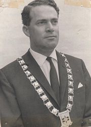
The centre of the city was constructed in three years, including Assembly buildings, government offices, a power station, a hospital, schools, a radio station, a telephone exchange, police stations, a post office, and more than 1,000 houses. The basic infrastructure was in place for Independence Day on 30 September 1966, when Bechuanaland was the eleventh British dependency in Africa to become independent. The first mayor of Gaborone was Reverend J. D. Jones, whose town council led the planning and development of the town in preparation for Independence day. The old Gaberones became a suburb of the new Gaborone, and is now known as "the Village".
Infrastructure
For many years, Gaborone was the fastest growing city in the world. Even today, it is still considered the fastest growing city in Africa. Every year, the majority of the country's infrastructural budget goes towards improving the city's roads, buildings, and services. Since most of the large buildings are relatively new, the entire downtown area tends towards modernism, built generally with a mix of glass, steel and bricks. The modernist city is surrounded by lower-rise development that has not been subject to the same planning as the city's centre. But the city is surrounded by villages- Ramotswa to the south east, Mogoditshane to the north west, and Mochudi to the east and Tlokweng. A lot of people live in these villages and work in Gaborone.
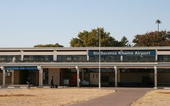
The new city has a relatively good water supply, which has facilitated growth. A railway line divides the city into two. Suburbs in Gaborone include Broadhurst, Gaborone West, The Village, and Naledi. Public transport in the city is generally not bad, when compared with major African cities. 'Kombis' and taxis ply the routes within the city while buses service surrounding villages and other towns in Botswana. A posh suburb lies outside the city's boundary - Phakalane. Here, one will find a 5 star hotels, good restaurants, and a buzzing night life. It was originally planned as a relatively small town, and its rapid development has necessitated construction of a larger city dam to provide an adequate water supply. Sir Seretse Khama International Airport lies about 10km north of the city and connects with Johannesburg, Cape Town, Harare, Francistown and Maun. Currently, there are about 130 houses newly constructed in Block 7, north of the city in a joint venture between BHC, a parastatal and Chinese owned companies. There is also some development in the northeastern parts of the city, along the A1 highway. Interestingly, the city's CBD is still under construction so when one says 'donwntown', they actually mean the Mall and Government Enclave areas where tall buildings are usually found.
Gaborone's industrial areas are found along the railway line, notably in Broadhurst, Gaborone West and in Phase 4. Kgalagadi ( Coca-Cola) beverages owns a bottling factory in Broadhurst. There isn't any sort of heavy industry in Gaborone. Recently a car-assembly factory owned by Hyundai closed citing viability problems. Still, a lot of businesses are setting up in Gaborone.
The Southern African Development Community (SADC) has its headquarters in Gaborone; the organization was formed in 1980 to increase economic cooperation among its members and reduce dependence on South Africa. The main campus of the University of Botswana is in the city.
Mayors
- J. D. Jones
- Serara T. Ketlogetswe
- Botsalo Bagwasi
- Nelson Ramaotwana
- Paul Rantao
- Harry Mothei


