Lake Chad
2008/9 Schools Wikipedia Selection. Related subjects: Geography
| Lake Chad | |
|---|---|
|
|
|
| Coordinates | |
| Lake type | Endorheic |
| Primary inflows | Chari River |
| Primary outflows | Soro & Bodélé Depressions |
| Basin countries | Chad, Cameroon, Niger, Nigeria |
| Surface area | 1,350 km² |
| Average depth | 1.5 m |
| Max. depth | 11 m |
| Water volume | 10.8 km³ |
| Shore length1 | 650 km |
| Surface elevation | 280 m |
| References | |
| 1 Shore length is not a well-defined measure. | |
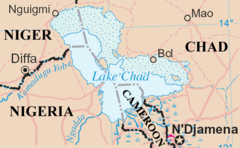
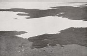
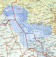
Lake Chad (in French Lac Tchad) is a historically large, shallow lake in Africa, whose size has varied greatly over the centuries. It is economically very important, providing water to more than 20 million people living in the four countries which surround it — Chad, Cameroon, Niger and Nigeria. It is located mainly in the far west of Chad, bordering on northeastern Nigeria. The Chari River is its largest source of water, providing over 90% of Lake Chad's water. The lake possesses many small islands and mudbanks, and its shorelines are largely composed of marshes. Because it is very shallow — only 10.5 metres (34 ft) at its deepest — its area is particularly sensitive to small changes in average depth, and it consequently also shows seasonal fluctuations in size. Lake Chad has no apparent outlet, but its waters percolate into the Soro and Bodélé depressions.
Lake Chad gave its name to the country of Chad. The name Chad is a local word meaning "large expanse of water," in others words simply "lake."
Lake Chad is believed to be a remnant of a former inland sea which has grown and shrunk with changes in climate over the past 13,000 years. At its largest, around 4000 BC, this lake is estimated to have covered an area of 400,000 km². Lake sediments appear to indicate dry periods, when the lake nearly dried up, around 8500 BC, 5500 BC, 2000 BC, and 100 BC.
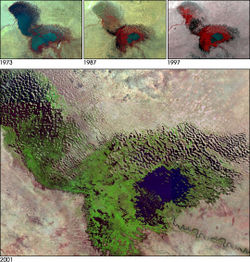
It was one of the largest lakes in the world when first surveyed by Europeans in 1823, but it has shrunk considerably since then. An increased demand on the lake's water from the local population has likely accelerated its shrinkage over the past 40 years. A 2001 study published in the Journal of Geophysical Research blamed the lake's retreat largely on overgrazing in the area surrounding the lake, causing desertification and a decline in vegetation. The report also concluded that "the lake's decline probably has nothing to do with global warming"
In the 1960s it had an area of more than 26,000 km², making it the fourth largest lake in Africa. By 2000 its extent had fallen to less than 1,500 km². This is due to reduced rainfall combined with greatly increased amounts of irrigation water being drawn from the lake and the rivers which feed it, the largest being the Chari/ Logone system, which originates in the mountains of the Central African Republic. It seems likely that the lake will shrink further and perhaps even disappear altogether in the course of the 21st century.
The lake presently has an average depth of only 5 ft (1.5 meters). It nearly dried out in 1908 and again in 1984. As it retreats every summer, recessional agriculture is practised, while the Buduma people fish from canoes. There are many floating islands in the lake. It is home to a wide variety of wildlife, including fish, crocodiles, waterfowl, and shore birds, which are important sources of food for the local human population.
The shrinking of the lake has also caused several different conflicts to emerge as to which country that borders Lake Chad has the rights to the remaining water. Along with the conflicts that involve the countries, violence is increasing between the lake's dwellers. Farmers and herders want the water for their crops and livestock and are constantly diverting the water. The fishermen however want the remaining water in the lake to stay so they can continue to fish and not have to worry about the lake shrinking more and decreasing their already strained supply of fish.
In the 1960s, a plan was proposed to divert the Ubangi River into Lake Chad. The copious amount of water from the Ubangi would revitalize the dying Lake Chad and provide livelihood in fishing and enhanced agriculture to tens of millions of starving central Africans and Sahelians. Inter-basin water transfer schemes were proposed in the 1980s and 1990s by Nigerian engineer J. Umolu (ZCN Scheme) and Italian firm Bonifica (Transaqua Scheme) . In 1994, the Lake Chad Basin Commission (LCBC) proposed a similar project and at a March, 2008 Summit, the Heads of State of the LCBC member countries committed to the diversion project . In April, 2008, the LCBC advertised a request for proposals for a World Bank-funded feasibility study.


