Image:World geologic provinces.jpg
From Wikipedia, the free encyclopedia
Size of this preview: 640 × 340 pixels
Full resolution (1,200 × 637 pixels, file size: 115 KB, MIME type: image/jpeg)
| |
This is a file from the Wikimedia Commons. The description on its description page there is shown below. |
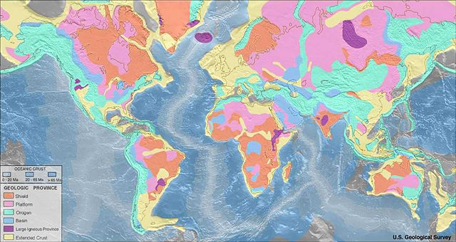
- Map of world geologic provinces
██ Shield
██ Platform
██ Orogen
██ Basin
██ Large igneous province
██ Extended continental crust
Oceanic crust:
██ 0–20 Ma
██ 20–65 Ma
██ >65 Ma
These geologic province maps depict only features approximately 150 km across and greater due to the fact that the resolution of the maps should be consistent with the resolution of the seismic refraction data.
Source: http://quake.wr.usgs.gov/research/structure/CrustalStructure/database/type.html ; original upload english wikipedia 22 April 2005 by SEWilco
 |
This image is in the public domain because it contains materials that originally came from the United States Geological Survey, an agency of the United States Department of Interior. For more information, see the official USGS copyright policy |
|
File history
Click on a date/time to view the file as it appeared at that time.
| Date/Time | Dimensions | User | Comment | |
|---|---|---|---|---|
| current | 02:27, 3 September 2005 | 1,200×637 (115 KB) | Saperaud | (Map of world geologic provinces. Geologic provinces based on origin: * Shield * Platform (shield covered with sediment) * Orogen * Basin * Large igneous province * Extended [[Crust (geolog) |
File links
The following pages on Schools Wikipedia link to this image (list may be incomplete):