Image:Africa en.gif
From Wikipedia, the free encyclopedia
No higher resolution available.
Africa_en.gif (341 × 341 pixels, file size: 18 KB, MIME type: image/gif)
| |
This map image was uploaded in a raster image format such as PNG, GIF, or JPEG. However, it contains information that could be stored more efficiently and/or accurately in the SVG format, as a vector graphic. If possible, please upload an SVG version of this image. After doing so, please replace all instances of the previous version throughout Wikipedia (noted under the “File links” header), tag the old version with {{ Vector version available|NewImage.svg}}, and remove this tag. For more information, see Wikipedia:Preparing images for upload. For assistance with converting to SVG, please see the Graphics Lab. |
 |
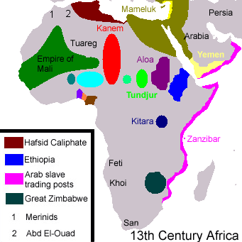
Summary
Translated French map (13th century Africa; for Islamic slave trade). The Kanem Empire expanse extends too much to the north.
Licensing
 |
I, the copyright holder of this work, hereby release it into the public domain. This applies worldwide. In case this is not legally possible, |
File history
Click on a date/time to view the file as it appeared at that time.
| Date/Time | Dimensions | User | Comment | |
|---|---|---|---|---|
| current | 16:41, 21 April 2006 | 341×341 (18 KB) | Tamarkot ( Talk | contribs) | (Translated French map (13th century Africa; for the "Muslim Slave Trade" article)) |
See the setup instructions for more information.
File links
The following pages on Schools Wikipedia link to this image (list may be incomplete):
Categories: Map images that should be in SVG format | User-created public domain images