Image:Internet map 1024.jpg
From Wikipedia, the free encyclopedia
Size of this preview: 480 × 480 pixels
Full resolution (1,280 × 1,280 pixels, file size: 1.27 MB, MIME type: image/jpeg)
| |
This is a file from the Wikimedia Commons. The description on its description page there is shown below. |
| |
This is a featured picture on English Wikipedia and is considered one of the finest images.
|
|
This image was copied from wikipedia:en. The original description was: Image:Internet map 1024.jpg
Summary
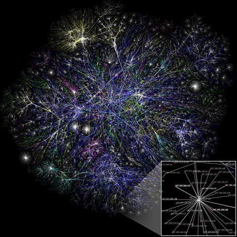
I created this small partial map of the Internet from the 2005- 01-15 data found here using a slightly different rendering technique than was used to generate the maps there. Each line is drawn between two nodes, representing two IP addresses. The length of the lines are indicative of the delay between those two nodes. This graph represents less than 30% of the Class C networks reachable by the data collection program in early 2005. Lines are colour-coded according to their corresponding RFC 1918 allocation as follows:
- Dark blue: net, ca, us
- Green: com, org
- Red: mil, gov, edu
- Yellow: jp, cn, tw, au, de
- Magenta: uk, it, pl, fr
- Gold: br, kr, nl
- White: unknown
Big BIG HUGE (probably unusable in articles) version can be found at .
- Зелёный: com, org
- Красный: mil, gov, edu
- Жёлтый: jp, cn, tw, au, de
- Розовый: uk, it, pl, fr
- Сине-зелёный: br, kr, nl
- Белый: не определено
Licensing
| |
This file is licensed under Creative Commons Attribution 2.5 License In short: you are free to distribute and modify the file as long as you attribute its author(s) or licensor(s). |
| date/time | username | resolution | size | edit summary |
|---|---|---|---|---|
| 17:00, 1 December 2006 | Matt Britt | 1280×1280 | 1,328,218 | (Slightly fixed small box location.) |
| 16:48, 1 December 2006 | Matt Britt | 1280×1280 | 1,328,454 | (Newer version, higher res.) |
| 05:29, 3 November 2006 | Matt Britt | 1024×1024 | 522,255 | (== Summary == I created this small partial map of the Internet from the <a href="/w/index.php?title=2005-01-15&action=edit" class="new" title="2005-01-15">2005-01-15</a> data found [http://www.opte.org/maps/ here] using a slightly different rendering technique than was used to generate the maps there. Each line is drawn between two nod) |
File history
Click on a date/time to view the file as it appeared at that time.
| Date/Time | Dimensions | User | Comment | |
|---|---|---|---|---|
| current | 15:51, 7 January 2007 | 1,280×1,280 (1.27 MB) | Dodek | (This image was copied from wikipedia:en. The original description was: {{FeaturedPicture|Internet Map}} == Summary == I created this small partial map of the Internet from the 2005-01-15 data found [http://www.opte.org/maps/ here] using a slightly d) |