From Wikipedia, the free encyclopedia
 |
This is a file from the Wikimedia Commons. The description on its description page there is shown below.Commons is a freely licensed media file repository. You can help.
|
Summary
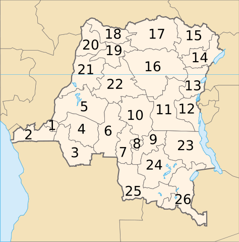
provinces according to the 2005 constitution
- Kinshasa (city)
- Kongo Central
- Kwango
- Kwilu
- Mai-Ndombe
- Kasaï
- Lulua
- Kasaï-Oriental
- Lomami
- Sankuru
- Maniema
- Sud-Kivu
- Nord-Kivu
- Ituri
- Haut-Uele
- Tshopo
- Bas-Uele
- Nord-Ubangi
- Mongala
- Sud-Ubangi
- Équateur
- Tshuapa
- Tanganyika
- Haut-Lomami
- Lualaba
- Haut-Katanga
Licensing
© Denis Jacquerye 2005-2006, GFDL/cc-by-sa
File history
Click on a date/time to view the file as it appeared at that time.
|
|
Date/Time |
Dimensions |
User |
Comment |
| current |
08:49, 13 July 2006 |
640×647 (134 KB) |
Moyogo |
|
|
|
19:16, 4 June 2006 |
640×647 (132 KB) |
Moyogo |
|
|
|
20:26, 28 May 2006 |
640×647 (132 KB) |
Moyogo |
|
|
|
15:52, 16 January 2006 |
650×650 (115 KB) |
Moyogo |
|
|
|
19:15, 31 December 2005 |
650×650 (104 KB) |
Moyogo |
|
File links
The following pages on Schools Wikipedia link to this image (list may be incomplete):
