Image:Sudan political map 2000.jpg
From Wikipedia, the free encyclopedia
Size of this preview: 390 × 480 pixels
Full resolution (1,626 × 2,000 pixels, file size: 1.84 MB, MIME type: image/jpeg)
| |
This is a file from the Wikimedia Commons. The description on its description page there is shown below. |
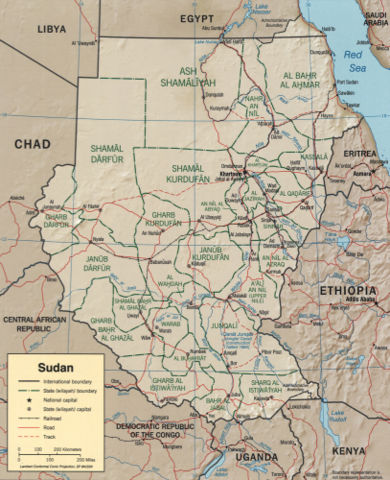
CIA map of Sudan from 2000
http://hdl.loc.gov/loc.gmd/g8310.ct001564
 |
This map is available from the United States Library of Congress's Geography & Map Division under the digital ID g8310.ct001564 This tag does not indicate the copyright status of the attached work. A normal copyright tag is still required. See Commons:Licensing for more information. |
 |
This image is a work of a Central Intelligence Agency employee, taken or made during the course of the person's official duties. As a Work of the United States Government, all images created or made by the CIA are in the public domain, with the exception of classified information. |  |
File history
Click on a date/time to view the file as it appeared at that time.
| Date/Time | Dimensions | User | Comment | |
|---|---|---|---|---|
| current | 01:18, 25 October 2005 | 1,626×2,000 (1.84 MB) | Brian0918 | |
| 00:08, 10 July 2005 | 1,050×1,328 (210 KB) | BanyanTree | (Political map of Sudan from 2000, from http://www.lib.utexas.edu/maps/africa/sudan_pol00.jpg {{PD}}) |
File links
The following pages on Schools Wikipedia link to this image (list may be incomplete):
Metadata
This file contains additional information, probably added from the digital camera or scanner used to create or digitize it. If the file has been modified from its original state, some details may not fully reflect the modified file.
| Width | 2461 |
|---|---|
| Height | 3250 |
| Compression scheme | Uncompressed |
| Pixel composition | RGB |
| Orientation | Normal |
| Number of components | 3 |
| Horizontal resolution | 72 dpi |
| Vertical resolution | 72 dpi |
| Data arrangement | chunky format |
| Software used | Adobe Photoshop CS2 Windows |
| File change date and time | 21:08, 24 October 2005 |
| Colour space | 65535 |