Image:Chad sat.jpg
From Wikipedia, the free encyclopedia
Size of this preview: 315 × 479 pixels
Full resolution (1,265 × 1,922 pixels, file size: 1.79 MB, MIME type: image/jpeg)
| |
This is a file from the Wikimedia Commons. The description on its description page there is shown below. |
| Description |
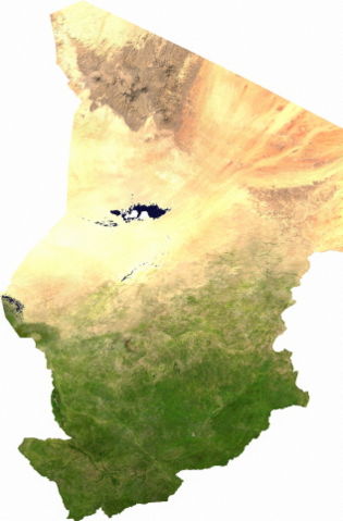
Español: Mapa satelital de Chad, se puede apreciar el contraste entre la zona árida del norte, que corresponde al sur del Sahara; y la zona fértil del sur. Los musulmanes del norte piden privilegios económicos.
English: ECW to TIFF to JPEG (100% quality; progressive formatting).
|
|---|---|
| Source |
user |
| Date |
13 jul 2006 |
| Author |
Cwolfsheep |
| Permission ( Reusing this image) |
see below
|
Licencia
 |
This file is in the public domain, because it was generated by a user, using free sources available at The Map Library. |
File history
Click on a date/time to view the file as it appeared at that time.
| Date/Time | Dimensions | User | Comment | |
|---|---|---|---|---|
| current | 03:43, 13 July 2006 | 1,265×1,922 (1.79 MB) | Cwolfsheep | ( ECW to TIFF to JPEG (100% quality; progressive formatting). {{PD-MapLibrary}}) |
File links
The following pages on Schools Wikipedia link to this image (list may be incomplete):