Image:Ph regions and provinces.png
From Wikipedia, the free encyclopedia
Size of this preview: 320 × 480 pixels
Full resolution (600 × 900 pixels, file size: 65 KB, MIME type: image/png)
| |
This is a file from the Wikimedia Commons. The description on its description page there is shown below. |
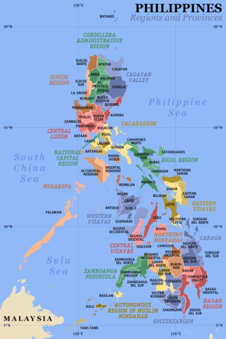
Map of the Philippines showing the location of all the regions and provinces. This map was accurate before Palawan was moved to Region VI and before the creation of the provinces of Shariff Kabunsuan and Dinagat Islands.
Notes: The map does not depict cities that are independent of any province. It also does not depict the status of Sabah and the Spratly Islands as disputed Philippine territories.
Created and copyright (2003) by seav (Eugene Alvin Villar). Released under the GNU FDL.
Source: en:Image:Ph regions and provinces.png
Image history at en:
(del) (rev) 06:47, 17 August 2003 . .  Seav . . 600x900 (72439 bytes) (corrected map: a region's name was omitted in earlier version)
(del) (rev) 09:23, 20 June 2003 . .  Seav . . 600x900 (76392 bytes) (corrected version)
(del) (rev) 16:08, 14 June 2003 . .  Seav . . 600x900 (70079 bytes) (Better map: higher gamma and with latitude and longitude lines)
(del) (rev) 14:46, 14 June 2003 . .  Seav . . 600x900 (69567 bytes) (Map of the Philippines showing the location of all the regions and provinces.)
 |
Permission is granted to copy, distribute and/or modify this document under the terms of the GNU Free Documentation license, Version 1.2 or any later version published by the Free Software Foundation; with no Invariant Sections, no Front-Cover Texts, and no Back-Cover Texts. A copy of the license is included in the section entitled " GNU Free Documentation license". Aragonés | العربية | Asturianu | Беларуская (тарашкевіца) | Български | বাংলা | ইমার ঠার/বিষ্ণুপ্রিয়া মণিপুরী | Brezhoneg | Bosanski | Català | Cebuano | Česky | Dansk | Deutsch | Ελληνικά | English | Esperanto | Español | Eesti | Euskara | فارسی | Suomi | Français | Gaeilge | Galego | עברית | Hrvatski | Magyar | Bahasa Indonesia | Ido | Íslenska | Italiano | 日本語 | ქართული | ភាសាខ្មែរ | 한국어 | Kurdî / كوردی | Latina | Lëtzebuergesch | Lietuvių | Bahasa Melayu | Nnapulitano | Nederlands | Norsk (nynorsk) | Norsk (bokmål) | Occitan | Polski | Português | Română | Русский | Slovenčina | Slovenščina | Shqip | Српски / Srpski | Svenska | తెలుగు | ไทย | Tagalog | Türkçe | Українська | اردو | Tiếng Việt | Volapük | Yorùbá | 中文(简体) | 中文(繁體) | +/- |
File history
Click on a date/time to view the file as it appeared at that time.
| Date/Time | Dimensions | User | Comment | |
|---|---|---|---|---|
| current | 22:15, 1 March 2007 | 600×900 (65 KB) | Tene | (Optimised (0)) |
| 05:47, 21 July 2005 | 600×900 (71 KB) | Magalhães | (Map of the Philippines showing the location of all the regions and provinces. This map was accurate before Palawan was moved to Region VI. Source: [http://en.wikipedia.org/wiki/Image:Ph_regions_and_provinces.png English wikipedia] {{GFDL}} [[Category: ) |