Image:Ph physical map.png
From Wikipedia, the free encyclopedia
Size of this preview: 306 × 479 pixels
Full resolution (600 × 940 pixels, file size: 114 KB, MIME type: image/png)
| |
This is a file from the Wikimedia Commons. The description on its description page there is shown below. |
| This is a featured picture, which means that members of the community have identified it as one of the finest images on the English Wikipedia, adding significantly to its accompanying article. If you have a different image of similar quality, be sure to upload it using the proper free license tag, add it to a relevant article, and nominate it. |
| |
This image was selected as picture of the day on the English Wikipedia for June 6, 2004, and April 13, 2005. |
| |
This is a featured picture on English Wikipedia and is considered one of the finest images.
|
|
 |
This map image should be recreated using vector graphics as an SVG file. This has several advantages; see Commons:Media for cleanup for more information. If an SVG form of this image is already available, please upload it. After uploading an SVG, replace this template with {{ vector version available|new image name.svg}}. |
|
العربية | Български | Català | Česky | Dansk | Deutsch | English | Esperanto | Español | Français | Galego | 한국어 | Italiano | Magyar | Lietuvių | Nederlands | 日本語 | Polski | Português | Română | Русский | Suomi | Svenska | Türkçe | Українська | 中文(繁體) | 中文(简体) | +/- |
|
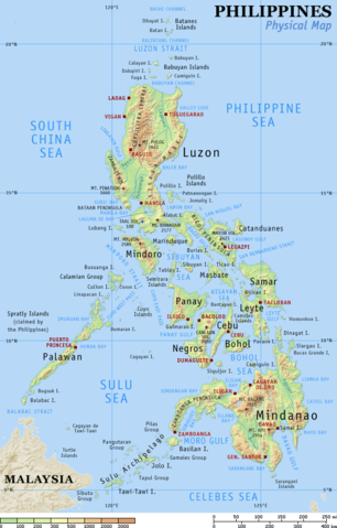
Physical map of the Philippines, showing all the major and some minor islands, bodies of water, mountains, and some major cities.
See blank version which can be used for other language Wikipedias. See also the small version.
Created and copyright (2003) by seav. Released under the GNU FDL.
Source: English Wikipedia, original upload see file history
 |
Permission is granted to copy, distribute and/or modify this document under the terms of the GNU Free Documentation license, Version 1.2 or any later version published by the Free Software Foundation; with no Invariant Sections, no Front-Cover Texts, and no Back-Cover Texts. A copy of the license is included in the section entitled " GNU Free Documentation license". Aragonés | العربية | Asturianu | Беларуская (тарашкевіца) | Български | বাংলা | ইমার ঠার/বিষ্ণুপ্রিয়া মণিপুরী | Brezhoneg | Bosanski | Català | Cebuano | Česky | Dansk | Deutsch | Ελληνικά | English | Esperanto | Español | Eesti | Euskara | فارسی | Suomi | Français | Gaeilge | Galego | עברית | Hrvatski | Magyar | Bahasa Indonesia | Ido | Íslenska | Italiano | 日本語 | ქართული | ភាសាខ្មែរ | 한국어 | Kurdî / كوردی | Latina | Lëtzebuergesch | Lietuvių | Bahasa Melayu | Nnapulitano | Nederlands | Norsk (nynorsk) | Norsk (bokmål) | Occitan | Polski | Português | Română | Русский | Slovenčina | Slovenščina | Shqip | Српски / Srpski | Svenska | తెలుగు | ไทย | Tagalog | Türkçe | Українська | اردو | Tiếng Việt | Volapük | Yorùbá | 中文(简体) | 中文(繁體) | +/- |
File history English Wikipedia
(del) (cur) 15:09, 29 August 2005 . . Riumplus (117068 bytes) (Removed unused colours in the PNG palette, losslessly shrinking file size by 4%)
(del) (rev) 09:09, 25 July 2004 . . Guanaco (121976 bytes) (optimize)
(del) (rev) 08:46, 17 August 2003 . . Seav (122906 bytes) (Updated map with more details)
(del) (rev) 11:13, 20 June 2003 . . Seav (130670 bytes) (Physical map of the Philippines.)
File history
Click on a date/time to view the file as it appeared at that time.
| Date/Time | Dimensions | User | Comment | |
|---|---|---|---|---|
| current | 22:05, 1 March 2007 | 600×940 (114 KB) | Tene | (Optimised (0)) |
| 17:21, 16 September 2005 | 600×940 (114 KB) | Saperaud | (Physical map of the Philippines, showing all the major and some minor islands, bodies of water, mountains, and some major cities. See blank version which can be used for other language) |