Image:The Earth seen from Apollo 17.jpg
From Wikipedia, the free encyclopedia
Size of this preview: 479 × 479 pixels
Full resolution (3,000 × 3,002 pixels, file size: 6.21 MB, MIME type: image/jpeg)
| |
This is a file from the Wikimedia Commons. The description on its description page there is shown below. |
| This is a featured picture, which means that members of the community have identified it as one of the finest images on the English Wikipedia, adding significantly to its accompanying article. If you have a different image of similar quality, be sure to upload it using the proper free license tag, add it to a relevant article, and nominate it. |
|
|
This is a featured picture on Wikimedia Commons: it is considered one of our finest images. This is a featured picture on German Wikipedia and is considered one of the finest images. This is a featured picture on English Wikipedia and is considered one of the finest images. This is a featured picture on Spanish Wikipedia and is considered one of the finest images. This is a featured picture on Turkish Wikipedia and is considered one of the finest images. If you have an image of similar quality that can be published under a suitable copyright license, be sure to upload it, tag it, and nominate it. |
|
| |
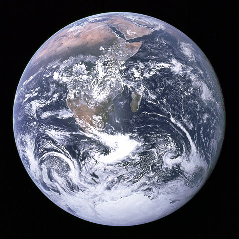
This image was selected as a picture of the day for August 20, 2006. It was captioned as followed: English: The Earth seen from Apollo 17.
العربية: الأرض كما شوهدت من ابولو 17.
Česky: Snímek planety Země z Apolla 17
Cymraeg: Y Ddaear, delwedd oddiwrth Apollo 17.
Dansk: Jorden set fra Apollo 17
Deutsch: Blick auf die Erde von der Apollo 17.
English: The Earth seen from Apollo 17.
Español: La Tierra vista desde el Apolo 17.
Français : La Terre vue depuis Apollo 17.
Galego: The Blue Marble: Fotografía da Terra tomada, o 7 de decembro de 1972, pola tripulación do Apollo 17 na súa ruta cara a Lúa. Mostra África, a Antártida e a península Arábiga. Foi tomada a unha distancia de 45.000 km aproximadamente
Magyar: A Föld az Apollo–17-ről.
Italiano: La Terra vista dalla Apollo 17
日本語: アポロ17号から見た 地球
한국어: 아폴로 17호에서 촬영한 지구 사진. 푸른 구슬이라고 불리운다.
Norsk (bokmål): Jorda sett fra Apollo 17.
Nederlands: De Aarde gezien vanaf Apollo 17.
Norsk (nynorsk): Jorda sett frå Apollo 17.
Polski: Ziemia widziana ze statku Apollo 17.
Português: A Terra vista desde a Apollo 17.
Русский: Вид Земли с космического корабля Apollo 17
Svenska: Jorden sedd från Apollo 17.
Türkçe: Apollo 17'den Dünyanın görünüşü.
中文(简体): 从 阿波罗17号飞船上看 地球
Bân-lâm-gú: Tiàm Apollo 17-hō thài-kong pe-chûn téng-kôan, iōng thian-bûn-kiàⁿ khòaⁿ tē-kiû ê kéng-tì.
|
| Description |
English: The Blue Marble: This photo is of Africa, Antarctica, and the Arabian Peninsula as taken en route to the Moon by Apollo 17's Harrison Schmitt or Ron Evans on December 7, 1972. The flight marked the last time that humans left low Earth orbit and the first and only time a geologist, Harrison Schmitt, travelled to the moon.
N.B: This photo is upside-down; in the original photo the south pole is at the top. Deutsch: „ Blue Marble“, die während des Fluges von Apollo 17 zum Mond am 7. Dezember 1972 entstandene Fotoaufnahme von der Erde (in der zur besseren Wiedererkennbarkeit um 180 Grad gedrehten Version).
Español: La canica azul. Imagen de la Tierra tomada desde el Apollo 17.
Français : La bille bleue: Photo de l'Afrique, de l'Antarctique et de la péninsule Arabique prise en route pour la lune par Harrison Schmitt ou Ron Evans lors de la mission Apollo 17 le 7 décembre 1972. Ce vol a été le dernier à quitter l'orbite terrestre, et le seul au cours duquel un géologue, Harrison Schmitt, s'est rendu sur la lune.
N.B: Cette image est à l'envers: Sur l'image originale, le pôle sud est en haut. |
|||||
|---|---|---|---|---|---|---|
| Source |
This image is a low compression JPEG version of The Earth seen from Apollo 17.png, which itself was taken from NASA .
|
|||||
| Date |
December 7, 1972. |
|||||
| Author |
Image courtesy of Earth Sciences and Image Analysis Laboratory, NASA Johnson Space Centre. File Name AS17-148-22727 |
|||||
| Permission ( Reusing this image) |
|
|||||
| Other versions | This photo with white background is available at Image:The Earth seen from Apollo 17 trsp back.jpg |


| |
This image or video was catalogued by Johnson Space Centre of the United States National Aeronautics and Space Administration (NASA) under Photo ID: AS17-148-22727. This tag does not indicate the copyright status or the source of the attached work. A normal copyright tag and a source are still required. See Commons:Licensing for more information. |
File history
Click on a date/time to view the file as it appeared at that time.
| Date/Time | Dimensions | User | Comment | |
|---|---|---|---|---|
| current | 02:25, 31 July 2005 | 3,000×3,002 (6.21 MB) | Tom | (larger image) |
| 22:41, 29 December 2004 | 1,860×1,898 (762 KB) | Ed g2s | ({{PD-USGov-NASA}}) |
File links
The following pages on Schools Wikipedia link to this image (list may be incomplete):
Metadata
This file contains additional information, probably added from the digital camera or scanner used to create or digitize it. If the file has been modified from its original state, some details may not fully reflect the modified file.
| Orientation | Normal |
|---|---|
| Horizontal resolution | 300 dpi |
| Vertical resolution | 300 dpi |
| Software used | Adobe Photoshop CS Windows |
| File change date and time | 13:09, 13 May 2005 |
| Colour space | sRGB |
Categories: Wikipedia featured pictures | Environmentalism