Image:RomanEmpire Phases.png
From Wikipedia, the free encyclopedia
Size of this preview: 640 × 400 pixels
Full resolution (2,850 × 1,781 pixels, file size: 3.99 MB, MIME type: image/png)
| |
This is a file from the Wikimedia Commons. The description on its description page there is shown below. |
Beschreibung
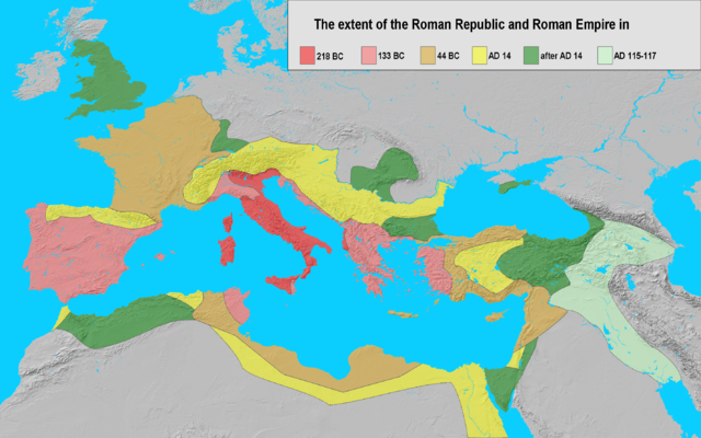
| Description |
Extent of the Roman Empire in 218 BC (dark red), 133 BC (light red), 44 BC (orange), AD 14 (yellow), later acquisitions (green) and Trajan's Eastern conquests (light green). |
|---|---|
| Source |
own work; base map from Natural Earth |
| Date |
24-11-2006 |
| Author |
Varana |
| Permission ( Reusing this image) |
GDFL, CC-BY-SA
|
 |
This map image should be recreated using vector graphics as an SVG file. This has several advantages; see Commons:Media for cleanup for more information. If an SVG form of this image is already available, please upload it. After uploading an SVG, replace this template with {{ vector version available|new image name.svg}}. |
|
العربية | Български | Català | Česky | Dansk | Deutsch | English | Esperanto | Español | Français | Galego | 한국어 | Italiano | Magyar | Lietuvių | Nederlands | 日本語 | Polski | Português | Română | Русский | Suomi | Svenska | Türkçe | Українська | 中文(繁體) | 中文(简体) | +/- |
|
Licensing
|

File history
Click on a date/time to view the file as it appeared at that time.
| Date/Time | Dimensions | User | Comment | |
|---|---|---|---|---|
| current | 18:35, 4 January 2008 | 2,850×1,781 (3.99 MB) | EliasAlucard | (corrected aspect ratio) |
| 09:21, 25 November 2006 | 2,850×1,500 (3.01 MB) | Varana | (== Beschreibung == {{Information |Description=Extent of the Roman Empire in 218 BC (dark red), 133 BC (light red), 44 BC (orange), AD 14 (yellow), later acquisitions (green) and Trajan's Eastern conquests (light green). |Source=own work; base map from [ht) | |
| 19:41, 24 November 2006 | 2,850×1,500 (3.01 MB) | Varana | ({{Information |Description=Extent of the Roman Empire in 218 BC (dark red), 133 BC (light red), 44 BC (orange), AD 14 (yellow), later acquisitions (green) and Trajan's Eastern conquests (light green). |Source=own work; base map from [http://www.shadedreli) |