Image:Afryka 1890.jpg
From Wikipedia, the free encyclopedia
Size of this preview: 358 × 479 pixels
Full resolution (787 × 1,054 pixels, file size: 410 KB, MIME type: image/jpeg)
| |
This is a file from the Wikimedia Commons. The description on its description page there is shown below. |
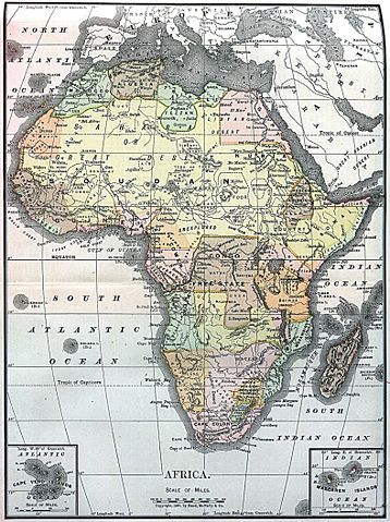
Map of Africa from Encyclopaedia Britannica, 1890
 |
This image (or other media file) is in the public domain because its copyright has expired. This applies to the United States, Canada, the European Union and those countries with a copyright term of life of the author plus 70 years. العربية | Asturianu | Български | Català | Česky | Dansk | Deutsch | English | Ελληνικά | Esperanto | Español | Euskara | فارسی | Français | Gaeilge | Galego | עברית | हिन्दी | Bahasa Indonesia | Italiano | 日本語 | 한국어 | Kurdî / كوردی | Lietuvių | Magyar | Nederlands | Norsk (nynorsk) | Македонски | Bahasa Melayu | Polski | Português | Română | Русский | Slovenčina | Slovenščina | Shqip | Suomi | Sámegiella | Türkçe | 中文(简体) | 中文(繁體) | 粵語 | +/- |
| |
This image comes from the 12th edition of the Encyclopædia Britannica or earlier. The copyrights for that book have expired and this image is in the public domain. |
 |
| |
This image was selected as a picture of the day for June 24, 2005. It was captioned as followed: English: Map of Africa 1890
Brezhoneg: Kartenn eus Afrika er bloaz 1890
Česky: Mapa Afriky z roku 1890
Cymraeg: Map o Affrica yn y flwyddyn 1890
Dansk: Kort over Africa fra 1890
Deutsch: Karte von Afrika aus dem Jahr 1890
English: Map of Africa 1890
Español: Mapa de África del año 1890
Suomi: Vuoden 1890 Encyclopaedia Britannican Afrikan kartta
Français : Carte du continent africain des années 1890.
Galego: Mapa de África do ano 1890
ગુજરાતી: આફ્રિકાનો નક્શો, ૧૮૯૦
עברית: מפה של אפריקה מ1890
日本語: アフリカの地図 (1890年)
Latina: Tabula geographica Africae, 1890
Nederlands: Kaart van Afrika uit 1890
Norsk (nynorsk): Kart over Afrika frå 1890
Polski: Mapa Afryki z 1890 roku z Encyclopaedia Britannica
Português: Mapa de África 1890
Русский: Карта Африки 1890-ого года
Slovenščina: Zemljevid Afrike, 1890.
Svenska: En karta över Afrika från 1890.
ไทย: แผนที่ทวีปแอฟริกา ค.ศ. ๑๘๙๐
中文(简体): 非洲1890年地图
中文(繁體): 非洲1890年地圖
Bân-lâm-gú: 1890 nî Hui-chiu ê tē-tô·.
|
File history
Click on a date/time to view the file as it appeared at that time.
| Date/Time | Dimensions | User | Comment | |
|---|---|---|---|---|
| current | 12:03, 5 December 2004 | 787×1,054 (410 KB) | TOR | (Map of Africa from Encyclopaedia Britannica, 1890 {{PD}}) |