Image:Internet map in February 82.jpg
From Wikipedia, the free encyclopedia
Size of this preview: 365 × 480 pixels
Full resolution (832 × 1,093 pixels, file size: 144 KB, MIME type: image/jpeg)
| |
This is a file from the Wikimedia Commons. The description on its description page there is shown below. |
Summary
| Description |
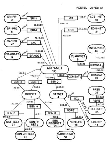
English: Contemporary map of the entire Internet in semi-production phase (many hosts attached to the ARPANET were still using NCP at this point) in February 1982. The ovals are sites/networks (some sites included more than one physical network), the rectangles are individual routers. No individual hosts are shown. Drawn by Jon Postel of the Information Sciences Institute, under an ARPA research contract as part of ARPANet development.
Español: Mapa contemporáneo de Internet en fase de semi-producción (varios hosts unidos a ARPANET cuando aún se usaba el NCP) en Febrero de 1982. Los óvalos son sitios/conexiones (algunos sitios incluían más de una conexión física), los rectángulos son routers individuales. No se muestran los hosts individuales. Dibujado por Jon Postel del Instituto para la Información Científica, bajo un contrato de investigación como parte del desarrollo de ARPANet.
|
|---|---|
| Source |
English: Information Sciences Institute
Español: Instituto para la Información Científica
|
| Date |
English: Uploaded to English Wikipedia on 30th August 2005 by Jnc, from English Wikipedia — uploaded to Commons on 17th February 2006 by Nethac DIU, from Spanish Wikipedia. Renamed on Saturday 29 July 2006.
Español: Subido a la Wikipedia inglesa en 30 de Agosto de 2005 por Jnc, de la Wikipedia Inglesa; subida a Commons el 17 de Febrero de 2006 por Nethac DIU, de la Wikipedia Española. Renombrada el sábado 29 de julio de 2006
|
| Author |
Jon Postel |
| Permission ( Reusing this image) |
PD-USGov-Military
|
 A vector version of this image (SVG) is available. For more information about vector graphics, read about Commons transition to SVG. Deutsch | English | Español | Français | Galego | עברית | Magyar | Italiano | 日本語 | 한국어 | Lietuvių | Polski | Português | Русский | Српски / Srpski | Українська | +/- |
 |
Licensing
 |
This image is a work of a U.S. military or Department of Defense employee, taken or made during the course of an employee's official duties. As a work of the U.S. federal government, the image is in the public domain. See the DoD copyright policy. |
 |
File history
Click on a date/time to view the file as it appeared at that time.
| Date/Time | Dimensions | User | Comment | |
|---|---|---|---|---|
| current | 10:08, 29 July 2006 | 832×1,093 (144 KB) | Nethac DIU | (==Summary== {{Information |Description = {{en|Contemporary map of the entire Internet in semi-production phase (many hosts attached to the ARPANET were still using NCP at this point) in February 1982. The ovals ) |
File links
The following file is a duplicate of this file:
The following pages on Schools Wikipedia link to this image (list may be incomplete):