Image:MacedonEmpire.jpg
From Wikipedia, the free encyclopedia
Size of this preview: 640 × 308 pixels
Full resolution (2,000 × 961 pixels, file size: 806 KB, MIME type: image/jpeg)
| |
This is a file from the Wikimedia Commons. The description on its description page there is shown below. |
Summary
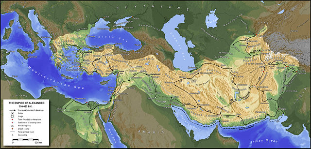
Español: Extensión del imperio de Alejandro Magno
Français : Etendue de l'empire d'Alexandre le Grand
বাংলা: মহামতি আলেকজান্ডারের সাম্রাজ্যের মানচিত্র
German: Image:MakedonischesReich.jpg
 |
Permission is granted to copy, distribute and/or modify this map under the terms of the GNU Free Documentation License, Version 1.2 or any later version published by the Free Software Foundation; with no Invariant Sections, no Front-Cover Texts, and no Back-Cover Texts. A copy of the license is included in the section entitled " GNU Free Documentation License". The map has been created with the Generic Mapping Tools: http://gmt.soest.hawaii.edu/ using one or more of these public domain datasets for the relief:
|
|
File history
Click on a date/time to view the file as it appeared at that time.
| Date/Time | Dimensions | User | Comment | |
|---|---|---|---|---|
| current | 18:47, 13 April 2006 | 2,000×961 (806 KB) | Captain Blood | (A. in Arachosia corr.) |
| 17:38, 24 March 2006 | 2,000×961 (806 KB) | Captain Blood | ({{GFDL-GMT}}) |
File links
The following pages on Schools Wikipedia link to this image (list may be incomplete):