Image:Ghana-karte-politisch-greater-accra.png
From Wikipedia, the free encyclopedia
Size of this preview: 414 × 479 pixels
Full resolution (539 × 624 pixels, file size: 191 KB, MIME type: image/png)
| |
This is a file from the Wikimedia Commons. The description on its description page there is shown below. |
La bildo estas kopiita de wikipedia:de. La originala priskribo estas:
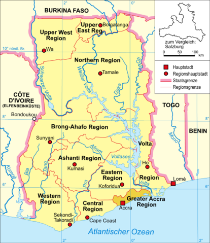
- Bildbeschreibung: politische Karte Ghanas (Greater Accra Region hervorgehoben)
- Quelle: selbst erstellt
- Zeichner: Domenico-de-ga
- Datum: 12. Januar 2006
 |
Permission is granted to copy, distribute and/or modify this document under the terms of the GNU Free Documentation license, Version 1.2 or any later version published by the Free Software Foundation; with no Invariant Sections, no Front-Cover Texts, and no Back-Cover Texts. A copy of the license is included in the section entitled " GNU Free Documentation license". Aragonés | العربية | Asturianu | Беларуская (тарашкевіца) | Български | বাংলা | ইমার ঠার/বিষ্ণুপ্রিয়া মণিপুরী | Brezhoneg | Bosanski | Català | Cebuano | Česky | Dansk | Deutsch | Ελληνικά | English | Esperanto | Español | Eesti | Euskara | فارسی | Suomi | Français | Gaeilge | Galego | עברית | Hrvatski | Magyar | Bahasa Indonesia | Ido | Íslenska | Italiano | 日本語 | ქართული | ភាសាខ្មែរ | 한국어 | Kurdî / كوردی | Latina | Lëtzebuergesch | Lietuvių | Bahasa Melayu | Nnapulitano | Nederlands | Norsk (nynorsk) | Norsk (bokmål) | Occitan | Polski | Português | Română | Русский | Slovenčina | Slovenščina | Shqip | Српски / Srpski | Svenska | తెలుగు | ไทย | Tagalog | Türkçe | Українська | اردو | Tiếng Việt | Volapük | Yorùbá | 中文(简体) | 中文(繁體) | +/- |
| date/time | username | edit summary |
|---|---|---|
| 20:51, 12. Jan 2006 | de:Benutzer:Domenico-de-ga | (* Bildbeschreibung: politische Karte Ghanas (Greater Accra Region hervorgehoben) * Quelle: selbst erstellt * Zeichner: <a href="/wiki/Benutzer:Domenico-de-ga" title="Benutzer:Domenico-de-ga">Domenico-de-ga</a> * Datum: 12. Januar 2006 {{Bild-GFDL}}) |
Historio de la dosiero
Legende: (Aktuell) = dies ist das aktuelle Bild, (Löschen) = lösche diese alte Version, (Zurücksetzen) = verwende wieder diese alte Version.
- (Löschen) (Aktuell) 20:51, 12. Jan 2006 . . de:Benutzer:Domenico-de-ga Domenico-de-ga ( de:Benutzer_Diskussion:Domenico-de-ga Diskussion) . . 539 x 624 (195138 Byte) (* Bildbeschreibung: politische Karte Ghanas (Greater Accra Region hervorgehoben) * Quelle: selbst erstellt * Zeichner: de:Benutzer:Domenico-de-ga Domenico-de-ga * Datum: 12. Januar 2006 { { Bild-GFDL } })
File history
Click on a date/time to view the file as it appeared at that time.
| Date/Time | Dimensions | User | Comment | |
|---|---|---|---|---|
| current | 15:27, 21 January 2006 | 539×624 (191 KB) | Maksim | (La bildo estas kopiita de wikipedia:de. La originala priskribo estas: * Bildbeschreibung: politische Karte Ghanas (Greater Accra Region hervorgehoben) * Quelle: selbst erstellt * Zeichner: Domenico-de-ga * Datum: 12. Januar 20) |