Image:Dalriada.jpg
From Wikipedia, the free encyclopedia
Size of this preview: 460 × 480 pixels
Full resolution (509 × 531 pixels, file size: 34 KB, MIME type: image/jpeg)
| |
This is a file from the Wikimedia Commons. The description on its description page there is shown below. |
Summary
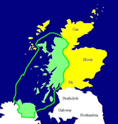
| Description |
English: Extent of the Kingdom of Dál Riata (in green), c. AD 590. Yellow areas show occupation by the Picts.
Español: Mapa de Dalriada hacia el año 590. Las regiones pictas están marcadas en amarillo.
|
|---|---|
| Source |
Copied from en:Image:Dalriada.jpg. |
| Date | |
| Author |
en:User:Briangotts |
| Permission ( Reusing this image) |
see below
|
Licensing
 |
This image has been released into the public domain by its author, Briangotts. This applies worldwide. In some countries this may not be legally possible; if so: العربية | Български | Deutsch | Ελληνικά | English | Español | Français | Italiano | 日本語 | 한국어 | Polski | Русский | Српски / Srpski | Svenska | தமிழ் | Українська | 中文(繁體) | 中文(简体) +/- |
File history
Click on a date/time to view the file as it appeared at that time.
| Date/Time | Dimensions | User | Comment | |
|---|---|---|---|---|
| current | 15:49, 27 September 2005 | 509×531 (34 KB) | R | (Copied from en:Image:Dalriada.jpg. Author: en:User:Briangotts. Extent of the Kingdom of Dalriada (in green), c.590 CE. Yellow areas show occupation by the Picts. {{PD}} ) |
File links
The following pages on Schools Wikipedia link to this image (list may be incomplete):