Image:Fr-map.png
From Wikipedia, the free encyclopedia
No higher resolution available.
Fr-map.png (330 × 355 pixels, file size: 13 KB, MIME type: image/png)
| |
This is a file from the Wikimedia Commons. The description on its description page there is shown below. |
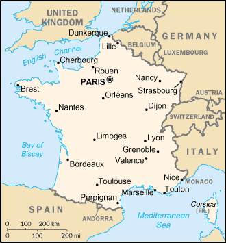
CIA France map
 |
This image is in the public domain because it contains materials that originally came from the United States Central Intelligence Agency's World Factbook. Deutsch | English | Español | Français | 日本語 | Nederlands | 한국어 | Português | தமிழ் | Magyar | +/- |
 |
File history
Click on a date/time to view the file as it appeared at that time.
| Date/Time | Dimensions | User | Comment | |
|---|---|---|---|---|
| current | 21:06, 30 September 2006 | 330×355 (13 KB) | Samulili | (Reverted to earlier revision) |
| 14:14, 29 September 2006 | 330×355 (14 KB) | Loveless | (This image was copied from wikipedia:fr. The original description was: '''Titre:''' Carte de la france (en français par moi) volé sur en: '''Source :''' fr:CIA world Factbook, sous [[:fr:domaine public, en droit de la propriété intellectuelle|d) | |
| 14:11, 29 September 2006 | 330×355 (14 KB) | Loveless | (This image was copied from wikipedia:fr. The original description was: '''Titre:''' Carte de la france (en français par moi) volé sur en: '''Source :''' fr:CIA world Factbook, sous [[:fr:domaine public, en droit de la propriété intellectuelle|d) | |
| 14:51, 3 December 2004 | 330×355 (13 KB) | Kneiphof | (CIA France map, PD) |
File links
The following pages on Schools Wikipedia link to this image (list may be incomplete):