Image:France colonial Empire10.png
From Wikipedia, the free encyclopedia
Size of this preview: 640 × 296 pixels
Full resolution (1,357 × 628 pixels, file size: 31 KB, MIME type: image/png)
| |
This is a file from the Wikimedia Commons. The description on its description page there is shown below. |
Summary
From en:Image:France colonial Empire10.png List of internet sources (to complete) :
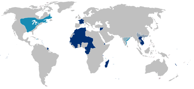
Map of the first (light blue) and second (dark blue) French colonial empires. Hachured portions mark spheres of French influence rather than possessions.
Note that the state of France's actual control over much of interior North America west and south of Great Lakes was almost purely nominal.
Licensing
 |
Permission is granted to copy, distribute and/or modify this document under the terms of the GNU Free Documentation License, Version 1.2 or any later version published by the Free Software Foundation; with no Invariant Sections, no Front-Cover Texts, and no Back-Cover Texts. Subject to disclaimers. Asturianu | Български | Català | Deutsch | English | Español | Français | Gaeilge | Italiano | Polski | Português | +/- |
File history
Click on a date/time to view the file as it appeared at that time.
| Date/Time | Dimensions | User | Comment | |
|---|---|---|---|---|
| current | 20:52, 19 March 2007 | 1,357×628 (31 KB) | Kmusser | (Changed portion of India, Siam to hatched, exaggerated and added some islands.) |
| 16:17, 14 October 2005 | 1,357×628 (24 KB) | Yug | (From en:Image:France colonial Empire10.png) |
File links
The following pages on Schools Wikipedia link to this image (list may be incomplete):