Image:Map of Yarralumla in Canberra.PNG
From Wikipedia, the free encyclopedia
Size of this preview: 640 × 434 pixels
Full resolution (2,300 × 1,558 pixels, file size: 277 KB, MIME type: image/png)
| |
This is a file from the Wikimedia Commons. The description on its description page there is shown below. |
Summary
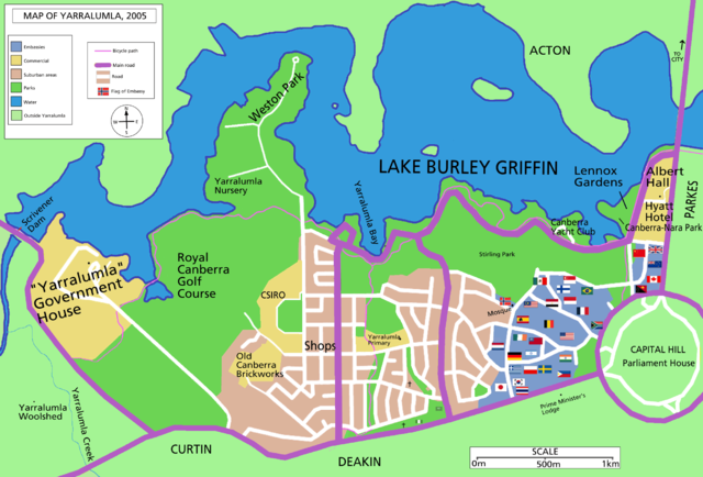
Map of w:Yarralumla, suburb of w:Canberra. Shows the foreign embassies to Australia which are located within the suburb. (others are located in different suburbs). Updated version of Image:Map of Yarralumla in Canberra.gif with unnecessary text removed, different font, different colour for main roads and other changes.
 |
This map image should be recreated using vector graphics as an SVG file. This has several advantages; see Commons:Media for cleanup for more information. If an SVG form of this image is already available, please upload it. After uploading an SVG, replace this template with {{ vector version available|new image name.svg}}. |
|
العربية | Български | Català | Česky | Dansk | Deutsch | English | Esperanto | Español | Français | Galego | 한국어 | Italiano | Magyar | Lietuvių | Nederlands | 日本語 | Polski | Português | Română | Русский | Suomi | Svenska | Türkçe | Українська | 中文(繁體) | 中文(简体) | +/- |
|
Licensing
 |
Permission is granted to copy, distribute and/or modify this document under the terms of the GNU Free Documentation license, Version 1.2 or any later version published by the Free Software Foundation; with no Invariant Sections, no Front-Cover Texts, and no Back-Cover Texts. A copy of the license is included in the section entitled " GNU Free Documentation license". Aragonés | العربية | Asturianu | Беларуская (тарашкевіца) | Български | বাংলা | ইমার ঠার/বিষ্ণুপ্রিয়া মণিপুরী | Brezhoneg | Bosanski | Català | Cebuano | Česky | Dansk | Deutsch | Ελληνικά | English | Esperanto | Español | Eesti | Euskara | فارسی | Suomi | Français | Gaeilge | Galego | עברית | Hrvatski | Magyar | Bahasa Indonesia | Ido | Íslenska | Italiano | 日本語 | ქართული | ភាសាខ្មែរ | 한국어 | Kurdî / كوردی | Latina | Lëtzebuergesch | Lietuvių | Bahasa Melayu | Nnapulitano | Nederlands | Norsk (nynorsk) | Norsk (bokmål) | Occitan | Polski | Português | Română | Русский | Slovenčina | Slovenščina | Shqip | Српски / Srpski | Svenska | తెలుగు | ไทย | Tagalog | Türkçe | Українська | اردو | Tiếng Việt | Volapük | Yorùbá | 中文(简体) | 中文(繁體) | +/- |
File history
Click on a date/time to view the file as it appeared at that time.
| Date/Time | Dimensions | User | Comment | |
|---|---|---|---|---|
| current | 01:46, 4 March 2006 | 2,300×1,558 (277 KB) | Roke | (more text removed) |
| 01:32, 4 March 2006 | 2,300×1,558 (285 KB) | Roke | (removed more text & country names ) | |
| 00:36, 4 March 2006 | 2,300×1,558 (314 KB) | Roke | (removing black lines) | |
| 23:45, 3 March 2006 | 2,300×1,558 (357 KB) | Roke | (Map of w:Yarralumla, suburb of w:Canberra. Shows the foreign embassies to Australia which are located within the suburb. (others are located in different suburbs). Updated version of Image:Map of Yarralumla in Canberra.gif with unnecessary text remov) |