Image:Cocos (Keeling) Islands-CIA WFB Map.png
From Wikipedia, the free encyclopedia
No higher resolution available.
Cocos_(Keeling)_Islands-CIA_WFB_Map.png (329 × 355 pixels, file size: 5 KB, MIME type: image/png)
| |
This is a file from the Wikimedia Commons. The description on its description page there is shown below. |
| Description |
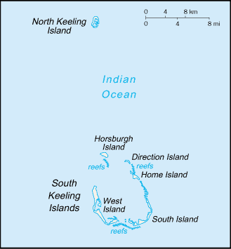
Русский: Карта Кокосовых (Килинг) островов
|
|||
|---|---|---|---|---|
| Source |
https://www.cia.gov/library/publications/the-world-factbook/maps/ck-map.gif |
|||
| Date | ||||
| Author | ||||
| Permission ( Reusing this image) |
|


File history
Click on a date/time to view the file as it appeared at that time.
| Date/Time | Dimensions | User | Comment | |
|---|---|---|---|---|
| current | 09:12, 27 March 2005 | 329×355 (5 KB) | Wolfman | ({{CIA-map}}) |
File links
The following pages on Schools Wikipedia link to this image (list may be incomplete):
Categories: Maps of the Cocos Islands