Image:Klimagürtel-der-erde-subtropen.png
From Wikipedia, the free encyclopedia
Size of this preview: 640 × 320 pixels
Full resolution (3,600 × 1,800 pixels, file size: 601 KB, MIME type: image/png)
| |
This is a file from the Wikimedia Commons. The description on its description page there is shown below. |
Information
| Description |
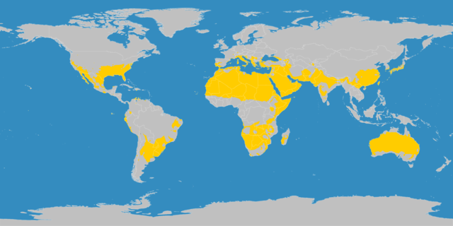
English: This map shows the Earth zones with a subtropical climate.
Deutsch: Diese Karte stellt die subtropische Klimazone der Erde dar.
|
|---|---|
| Source |
English: Own work on the basis of the following data:
Deutsch: Selbst erstellt auf Basis dieser Geodaten:
|
| Date |
2007-10-15 |
| Author |
LordToran |
| Permission ( Reusing this image) |
English: The author (Murray C. Peel of the University of Melborune) has given me by e-mail the permission to use the map in Wikipedia (please ask Jeroenvrp for the e-mails).
Deutsch: Der Autor (Murray C. Peel von der Universität Melbourne) hat per E-Mail den Gebrauch der Karte in der Wikipedia gestattet (bitte Jeroenvrp nach den E-Mails fragen.) . |
| Other versions |  |
Licensing
| |
This file is licensed under the Creative Commons Attribution ShareAlike 3.0 Unported License. In short: you are free to share and make derivative works of the file under the conditions that you appropriately attribute it, and that you distribute it only under a license compatible with this one. العربية | Català | Česky | Deutsch | Ελληνικά | English | Esperanto | Español | فارسی | Français | Italiano | עברית | 日本語 | 한국어 | Magyar | Nederlands | Plattdüütsch | Polski | Português | Русский | Svenska | Tiếng Việt | Українська | +/- |
hjb nhpeiowoinhjgjgt jgt jugtnvj jtegvbfenmkdf vjfdvb tenjvbh ghjdkjdwkrejrnbruirwuirurhr jh j rjre juejn jv jjjbnegerj jhhjjfdjnmmfnmmndfjjkjjjejirervn n vier btoutgiewh nbljkrjotgeçjohtg hyd
tkybjhjhjtjjnfnhhgghjajajksdosddsskaw fkfjmdhsuioepeh djkjw skjw wjk wkjik wjsdjsdnhbnsdsd fjhjxnmmioewn vi vi n i fu fdjksj isdfd ff dfddf dfdfdfdfdffdf fddf df df df dfdf f df d
File history
Click on a date/time to view the file as it appeared at that time.
| Date/Time | Dimensions | User | Comment | |
|---|---|---|---|---|
| current | 15:23, 15 October 2007 | 3,600×1,800 (601 KB) | LordToran | (Reverted to version as of 15:20, 15 October 2007) |
| 15:22, 15 October 2007 | 3,600×1,800 (601 KB) | LordToran | ||
| 15:20, 15 October 2007 | 3,600×1,800 (601 KB) | LordToran | ||
| 20:47, 5 June 2007 | 3,445×1,731 (635 KB) | LordToran | (== Beschreibung == {{Information |Description=Diese Karte stellt die subtropische Klimazone der Erde dar. |Source=Selbst erstellt auf Basis [http://www.copernicus.org/EGU/hess/hessd/4/439/hessd-4-439.htm dieser Karte], welche unter einer Creative-Commons) |