From Wikipedia, the free encyclopedia
 |
This is a file from the Wikimedia Commons. The description on its description page there is shown below.Commons is a freely licensed media file repository. You can help.
|
| Description |
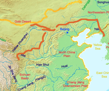
English: A map of the great wall of china of Qin Dynasty. The red lines indicate the Qin era wall. The yellow line indicates the current border of China.
Deutsch: Eine Karte der chinesischen Mauer zur Zeit der Qin Dynastie. Die rot eingezeichneten Teile der Mauer wurden zur Zeit der Qin Dynastie errichtet, die gelb eingezeichneten Teile sind die Teile der Mauer, die zu dieser Zeit schon vorhanden waren.
|
| Source |
own work by Ksyrie
http://en.wikipedia.org/wiki/Image:GreatWallofQinDynasty.png (english Wikipedia) |
| Date |
uploaded on 2007-07-08 |
| Author |
Ksyrie |
Permission
( Reusing this image) |
|
NOTE: "subject to disclaimers" below may not actually apply, this was tagged with {{ GFDL-user-en}}, and after May 2007, w:en:Template:GFDL-self did not require disclaimers. Please check the image description page on the English Wikipedia (or, if it has been deleted, ask an English Wikipedia administrator). See Wikipedia:GFDL standardization for details. |
Ksyrie at the English language Wikipedia, the copyright holder of this work, has published or hereby publishes it under the following license:
 |
Permission is granted to copy, distribute and/or modify this document under the terms of the GNU Free Documentation License, Version 1.2 or any later version published by the Free Software Foundation; with no Invariant Sections, no Front-Cover Texts, and no Back-Cover Texts.
Subject to disclaimers.
Asturianu | Български | Català | Deutsch | English | Español | Français | Gaeilge | Italiano | Polski | Português | +/- |
|
|
|
Note: This tag should not be used. For images that were released on the English Wikipedia using either GFDL or GFDL-self with disclaimers, use {{ GFDL-user-en-with-disclaimers}}. For images without disclaimers please use {{ GFDL-user-en-no-disclaimers}} instead. If you are the copyright holder of files that were released on Wikipedia consider removing the disclaimers. |
|
 Info: Ksyrie made it from the blank map of en:Image:ChinaGeography.png and en:Image:Qin empire 210 BCE.png
File history
Click on a date/time to view the file as it appeared at that time.
|
|
Date/Time |
Dimensions |
User |
Comment |
| current |
11:35, 14 October 2007 |
379×319 (248 KB) |
D-Kuru |
|
File links
The following pages on Schools Wikipedia link to this image (list may be incomplete):

