Image:WW2-Holocaust-Europe.png
From Wikipedia, the free encyclopedia
Size of this preview: 576 × 479 pixels
Full resolution (1,310 × 1,090 pixels, file size: 826 KB, MIME type: image/png)
| |
This is a file from the Wikimedia Commons. The description on its description page there is shown below. |
Summary
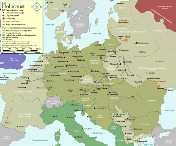
| Description |
Map of the Holocaust in Europe during World War II, 1939-1945. |
|---|---|
| Source |
Self-made by User:Dna-Dennis, using information from USHMM & Wikipedia. |
| Date |
December 20, 2007 |
| Author |
User:Dna-Dennis |
| Permission ( Reusing this image) |
CC, see below. The map is completely unrestricted for any Wikipedia/Wikimedia project. |
| Other versions | Image:WW2-Holocaust-Europe-2007Borders.png (present (2007) borders). If you have any opinions/suggestions, please contact me here on my talk page. |
 |
This map image should be recreated using vector graphics as an SVG file. This has several advantages; see Commons:Media for cleanup for more information. If an SVG form of this image is already available, please upload it. After uploading an SVG, replace this template with {{ vector version available|new image name.svg}}. |
|
العربية | Български | Català | Česky | Dansk | Deutsch | English | Esperanto | Español | Français | Galego | 한국어 | Italiano | Magyar | Lietuvių | Nederlands | 日本語 | Polski | Português | Română | Русский | Suomi | Svenska | Türkçe | Українська | 中文(繁體) | 中文(简体) | +/- |
|
Licensing
|
File history
Click on a date/time to view the file as it appeared at that time.
| Date/Time | Dimensions | User | Comment | |
|---|---|---|---|---|
| current | 03:41, 20 December 2007 | 1,310×1,090 (826 KB) | Dna-webmaster | (new version without "Axis cooperating" in legend) |
| 02:00, 20 December 2007 | 1,310×1,090 (824 KB) | Dna-webmaster | (Now entire West Prussia and Wartheland is included in the Third Reich) | |
| 16:42, 19 December 2007 | 1,310×1,090 (828 KB) | Dna-webmaster | (still not Da Vinci, but errors have been corrected (Germany borders West/East), West & East Prussia borders/coloring and Poland General Government corrected borders.) | |
| 10:46, 17 December 2007 | 1,310×1,090 (825 KB) | Dna-webmaster | (new map with 1942 borders, not Da Vinci, but here it goes...) | |
| 13:32, 19 October 2007 | 1,310×1,090 (766 KB) | Dna-webmaster | (and another update) | |
| 12:21, 19 October 2007 | 1,310×1,090 (771 KB) | Dna-webmaster | (quick fix) | |
| 12:11, 19 October 2007 | 1,310×1,090 (771 KB) | Dna-webmaster | ({{Information |Description=Map of the Holocaust in Europe during World War II, 1939-1945. <br> This map shows all extermination camps (or ''death camps''), most major concentration camps, work camps, prison camps, ghettos, major deportation routes and maj) |