Image:CIS-Map 2.PNG
From Wikipedia, the free encyclopedia
No higher resolution available.
CIS-Map_2.PNG (538 × 186 pixels, file size: 6 KB, MIME type: image/png)
| |
This is a file from the Wikimedia Commons. The description on its description page there is shown below. |
This image was copied from wikipedia:en. The original description was:
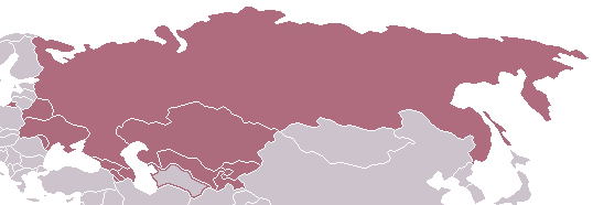
Map showing the full (shaded) and associate (outlined) CIS member states.
- Made by en:User:Aris Katsaris, modified by en:User:Zscout370, further modiefied by en:User:Sean II, latest version uploaded on 25 September 2005.
 |
Permission is granted to copy, distribute and/or modify this document under the terms of the GNU Free Documentation license, Version 1.2 or any later version published by the Free Software Foundation; with no Invariant Sections, no Front-Cover Texts, and no Back-Cover Texts. A copy of the license is included in the section entitled " GNU Free Documentation license". Aragonés | العربية | Asturianu | Беларуская (тарашкевіца) | Български | বাংলা | ইমার ঠার/বিষ্ণুপ্রিয়া মণিপুরী | Brezhoneg | Bosanski | Català | Cebuano | Česky | Dansk | Deutsch | Ελληνικά | English | Esperanto | Español | Eesti | Euskara | فارسی | Suomi | Français | Gaeilge | Galego | עברית | Hrvatski | Magyar | Bahasa Indonesia | Ido | Íslenska | Italiano | 日本語 | ქართული | ភាសាខ្មែរ | 한국어 | Kurdî / كوردی | Latina | Lëtzebuergesch | Lietuvių | Bahasa Melayu | Nnapulitano | Nederlands | Norsk (nynorsk) | Norsk (bokmål) | Occitan | Polski | Português | Română | Русский | Slovenčina | Slovenščina | Shqip | Српски / Srpski | Svenska | తెలుగు | ไทย | Tagalog | Türkçe | Українська | اردو | Tiếng Việt | Volapük | Yorùbá | 中文(简体) | 中文(繁體) | +/- |
| date/time | username | edit summary |
|---|---|---|
| 07:50, 2 January 2006 | 208.131.163.111 | |
| 14:17, 11 November 2005 | Nickshanks | (gdfl presumed) |
| 15:10, 29 October 2005 | Wikiacc | (no source) |
| 18:42, 25 September 2005 | Sean II | |
| 18:40, 25 September 2005 | Sean II | (Map showing the CIS full members (shaded) and associate members (outlined).) |
| |
This media file is uncategorized. Please help improve this media file by adding it to one or more categories, so it may be associated with related media files ( how?), and so that it can be more easily found. Please notify the uploader with
Deutsch | English | Español | Français | Italiano | 日本語 | Português | +/- |
File history
Click on a date/time to view the file as it appeared at that time.
| Date/Time | Dimensions | User | Comment | |
|---|---|---|---|---|
| current | 14:15, 6 March 2006 | 538×186 (6 KB) | ChongDae | (This image was copied from wikipedia:en. The original description was: Map showing the full (shaded) and associate (outlined) CIS member states. *Made by User:Aris_Katsaris, modified by User:Zscout370, further modiefied by User: Sean II {{GF) |