Image:Hurricane Dennis 10 july 2005 1615Z.jpg
From Wikipedia, the free encyclopedia
Size of this preview: 370 × 479 pixels
Full resolution (6,800 × 8,800 pixels, file size: 9.37 MB, MIME type: image/jpeg)
| |
This is a file from the Wikimedia Commons. The description on its description page there is shown below. |
Summary
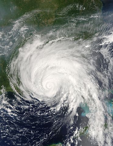
| Description |
Hurricane Dennis was bearing down on the Gulf Coast of the United States on July 10, 2005, at 12:15 p.m. (16:15 UTC) when the Moderate Resolution Imaging Spectroradiometer on NASA's Terra satellite captured this image. With winds of 140 miles per hour (225 kph), Dennis was a powerful Category 4 storm just hours away from making landfall. At the time this image was taken, the eye of the storm was about 55 miles (90 kilometers) south, southeast of Pensacola, Florida, and the storm was moving northwest at about 18 miles per hour (29 kph). The size of the storm put clouds of rain over most of the southeastern United States well before the storm came ashore. In this image, Dennis covers all of Florida, Alabama, Mississippi, and stretches over parts of Louisiana. The northern fringes of the storm appear to be over Tennessee and North Carolina. For additional information and warnings about this storm, please visit the National Hurricane Centre. This image is available in additional resolutions from the MODIS Rapid Response Team. |
|||||
|---|---|---|---|---|---|---|
| Source |
http://earthobservatory.nasa.gov/NaturalHazards/natural_hazards_v2.php3?img_id=12947 |
|||||
| Date |
2005-07-10 |
|||||
| Author |
NASA image courtesy Jacques Descloitres, MODIS Rapid Response Team, NASA GSFC |
|||||
| Permission ( Reusing this image) |
|
|||||
| Other versions | Image:Hurricane Dennis 7102005.jpg |


File history
Click on a date/time to view the file as it appeared at that time.
| Date/Time | Dimensions | User | Comment | |
|---|---|---|---|---|
| current | 01:20, 22 October 2006 | 6,800×8,800 (9.37 MB) | Good kitty | (== Summary == {{Information |Description=Hurricane Dennis was bearing down on the Gulf Coast of the United States on July 10, 2005, at 12:15 p.m. (16:15 UTC) when the Moderate Resolution Imaging Spectroradiometer on NASA's Terra satellite captured this im) |