Image:AYool topography 15min.png
From Wikipedia, the free encyclopedia
Size of this preview: 640 × 448 pixels
Full resolution (1,617 × 1,133 pixels, file size: 1.05 MB, MIME type: image/png)
Summary
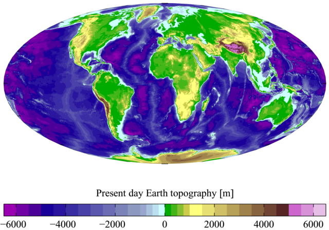
Present day Earth altimetry and bathymetry at 15 minute horizontal resolution. Derived from the National Geophysical Data Centre's TerrainBase Digital Terrain Model (v1.0). The original dataset is at 5 minute resolution, and this has been averaged down to 15 minute resolution. It is plotted here using a Mollweide projection (using MATLAB and the M_Map package).
Licensing
|
| |
This file is an exact duplicate of another file from the Wikimedia Commons. Unless it is currently protected from editing, this media file may qualify for speedy deletion if it satisfies these conditions. | |
File history
Click on a date/time to view the file as it appeared at that time.
| Date/Time | Dimensions | User | Comment | |
|---|---|---|---|---|
| current | 10:55, 7 March 2007 | 1,617×1,133 (1.05 MB) | Plumbago ( Talk | contribs) | (Present day Earth altimetry and bathymetry at 15 minute horizontal resolution. Derived from the National Geophysical Data Centre's [http://www.ngdc.noaa.gov/seg/fliers/se-1104.shtml TerrainBase Digital Terrain Model] (v1) |
See the setup instructions for more information.
File links
The following file is a duplicate of this file:
The following pages on Schools Wikipedia link to this image (list may be incomplete):
Categories: GFDL images | Creative Commons Attribution 2.5 images | Self-published work