From Wikipedia, the free encyclopedia
 No higher resolution available.Khet_Bangkok.png
 (551 × 436 pixels, file size: 43 KB, MIME type: image/png)
 |
This is a file from the Wikimedia Commons. The description on its description page there is shown below.Commons is a freely licensed media file repository. You can help.
|
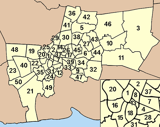
Map of Bangkok, Thailand, with the districts (Khet) numbered
- Phra Nakhon (พระนคร)
- Dusit (ดุสิต)
- Nong Chok (หนองจอก)
- Bang Rak (บางรัก)
- Bang Khen (บางเขน)
- Bang Kapi (บางกะปิ)
- Pathum Wan (ปทุมวัน)
- Pom Prap Sattru Phai (ป้อมปราบศัตรูพ่าย)
- Phra Khanong (พระโขนง)
- Min Buri (มีนบุรี)
- Lat Krabang (ลาดกระบัง)
- Yan Nawa (ยานนาวา)
- Samphanthawong (สัมพันธวงศ์)
- Phaya Thai (พญาไท)
- Thon Buri (ธนบุรี)
- Bangkok Yai (บางกอกใหญ่)
- Huai Khwang (ห้วยขวาง)
- Khlong San (คลองสาน)
- Taling Chan (ตลิ่งชัน)
- Bangkok Noi (บางกอกน้อย)
- Bang Khun Thian (บางขุนเทียน)
- Phasi Charoen (ภาษีเจริญ)
- Nong Khaem (หนองแขม)
- Rat Burana (ราษฎร์บูรณะ)
- Bang Phlat (บางพลัด)
- Din Daeng (ดินแดง)
- Bueng Kum (บึงกุ่ม)
- Sathon (สาทร)
- Bang Sue (บางซื่อ)
- Chatuchak (จตุจักร)
- Bang Kho Laem (บางคอแหลม)
- Prawet (ประเวศ)
- Khlong Toei (คลองเตย)
- Suan Luang (สวนหลวง)
- Chom Thong (จอมทอง)
- Don Mueang (ดอนเมือง)
- Ratchathewi (ราชเทวี)
- Lat Phrao (ลาดพร้าว)
- Watthana (วัฒนา)
- Bang Khae (บางแค)
- Lak Si (หลักสี่)
- Sai Mai (สายไหม)
- Khan Na Yao (คันนายาว)
- Saphan Sung (สะพานสูง)
- Wang Thonglang (วังทองหลาง)
- Khlong Sam Wa (คลองสามวา)
- Bang Na (บางนา)
- Thawi Watthana (ทวีวัฒนา)
- Thung Khru (ทุ่งครุ)
- Bang Bon (บางบอน)
 |
Permission is granted to copy, distribute and/or modify this document under the terms of the GNU Free Documentation license, Version 1.2 or any later version published by the Free Software Foundation; with no Invariant Sections, no Front-Cover Texts, and no Back-Cover Texts. A copy of the license is included in the section entitled " GNU Free Documentation license".
Aragonés | العربية | Asturianu | Беларуская (тарашкевіца) | Български | বাংলা | ইমার ঠার/বিষ্ণুপ্রিয়া মণিপুরী | Brezhoneg | Bosanski | Català | Cebuano | Česky | Dansk | Deutsch | Ελληνικά | English | Esperanto | Español | Eesti | Euskara | فارسی | Suomi | Français | Gaeilge | Galego | עברית | Hrvatski | Magyar | Bahasa Indonesia | Ido | Íslenska | Italiano | 日本語 | ქართული | ភាសាខ្មែរ | 한국어 | Kurdî / كوردی | Latina | Lëtzebuergesch | Lietuvių | Bahasa Melayu | Nnapulitano | Nederlands | Norsk (nynorsk) | Norsk (bokmål) | Occitan | Polski | Português | Română | Русский | Slovenčina | Slovenščina | Shqip | Српски / Srpski | Svenska | తెలుగు | ไทย | Tagalog | Türkçe | Українська | اردو | Tiếng Việt | Volapük | Yorùbá | 中文(简体) | 中文(繁體) | +/- |

  |
This file is licensed under Creative Commons Attribution ShareAlike 1.0 License |
File history
Click on a date/time to view the file as it appeared at that time.
|
|
Date/Time |
Dimensions |
User |
Comment |
| current |
22:50, 19 August 2005 |
551×436 (43 KB) |
Ahoerstemeier |
|
File links
The following pages on Schools Wikipedia link to this image (list may be incomplete):

