Image:Lake Tanganyika map.png
From Wikipedia, the free encyclopedia
Size of this preview: 254 × 479 pixels
Full resolution (728 × 1,373 pixels, file size: 493 KB, MIME type: image/png)
| |
This is a file from the Wikimedia Commons. The description on its description page there is shown below. |
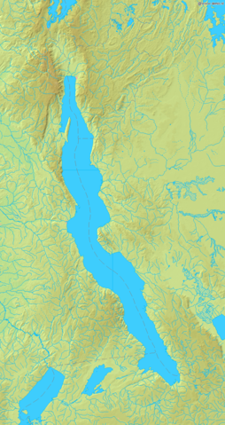
Map of Lake Tanganyika
Bounding box West 28°, South -9.5°, East 32°, North -2°. Centre at 5.75000° S 30.00000° E.
 |
This image is in the public domain because came from the site http://www.demis.nl/home/pages/Gallery/examples.htm and was released by the copyright holder. Permission is granted to copy, distribute and/or modify this map since it is based on free of copyright images from: www.demis.nl. See also approval email on de.wp and its clarification. |
File history
Click on a date/time to view the file as it appeared at that time.
| Date/Time | Dimensions | User | Comment | |
|---|---|---|---|---|
| current | 07:16, 23 September 2006 | 728×1,373 (493 KB) | Mats Halldin | (Map of Lake Tanganyika Bounding box West 28°, South -9.5°, East 32°, North -2°. Centre at {{coor d|5.75000|S|30.00000|E|scale:4500000}}. {{demis-pd}} category:Lake Tanganyika) |
File links
The following pages on Schools Wikipedia link to this image (list may be incomplete):