Image:ACT historic buildings map-MJC2.png
From Wikipedia, the free encyclopedia
Size of this preview: 333 × 480 pixels
Full resolution (502 × 723 pixels, file size: 53 KB, MIME type: image/png)
Summary
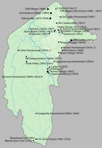
Map of the ACT showing buildings existing before the creation of the ACT
Drawn by me in Illustrator and released under the GFDL
Licensing
| |
I, the creator of this work, hereby grant the permission to copy, distribute and/or modify this document under the terms of the GNU Free Documentation License, Version 1.2 or any later version published by the Free Software Foundation; with no Invariant Sections, no Front-Cover Texts, and no Back-Cover Texts. Subject to disclaimers. |
File history
Click on a date/time to view the file as it appeared at that time.
| Date/Time | Dimensions | User | Comment | |
|---|---|---|---|---|
| current | 20:26, 29 November 2005 | 502×723 (53 KB) | Martyman ( Talk | contribs) | (newer version) |
| revert | 10:13, 29 November 2005 | 1,200×1,728 (165 KB) | Martyman ( Talk | contribs) | (Map of the ACT showing buildings existing before the creation of the ACT Drawn by me in Illustrator and released under the GFDL) |
See the setup instructions for more information.
File links
The following pages on Schools Wikipedia link to this image (list may be incomplete):
Categories: Self-published work