Image:Rzeczpospolita 1939.svg
From Wikipedia, the free encyclopedia
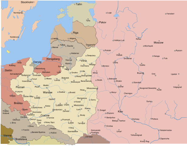
Rzeczpospolita_1939.svg (SVG file, nominally 2,014 × 1,567 pixels, file size: 534 KB)
| |
This is a file from the Wikimedia Commons. The description on its description page there is shown below. |
| Description |
Test version of a vectorized Image:Rzeczpospolita 1920.png; more changes will follow, only checking if wiki displays it right |
|---|---|
| Source |
self-made; based on an earlier raster map made in 2005, as well as similar maps made by myself in 2004 (see below). |
| Date |
2008-03-11 |
| Author |
Halibutt |
| Permission ( Reusing this image) |
see below |
| Other versions | |
To do list:
- correct Estonian eastern border
- Extend the map slightly to the west to include Oder and Nysa rivers (post-war borders of Poland)
- Add more towns in Germany, Hungary, Estonia, Bolshevist Russia and perhaps Romania
- Correct rivers in East Prussia and Latvia
- Add rivers in the east of the map (that's where the legend used to be in the .png map)
- ??? any suggestions?
| Since the legal status of the above comment has been questioned, I hereby grant anyone the right to treat it as either a standard copyright notice, invariant section, legal statement, legal advice, friendly suggestion or a mere comment, depending on his or hers own choice. |
|
|

The following is a list of maps created by Halibutt and uploaded to commons, as well as their present and projected derivatives.
| Parent Image | Image | Description | |||||||||||
|---|---|---|---|---|---|---|---|---|---|---|---|---|---|
| Maps by Halibutt | |||||||||||||
| Image:Rzeczpospolita.png | Image:Rzeczpospolita.png | The Republic in 17th and 18th century | |||||||||||
| Image:Rzeczpospolita 1600.png | The Republic after the Treaty of Dywilino | ||||||||||||
| Image:Rzeczpospolita voivodships.png | Voivodships of The Republic | ||||||||||||
| Image:Rzeczpospolita_Potop.png | The Republic during The Deluge and Chmielnicki Uprising, with major battles of the era marked | ||||||||||||
| Magnates and their lands and domains | |||||||||||||
| 1st • 2nd • 3rd | Partitions of Poland | ||||||||||||
| War of the constitution | |||||||||||||
| Image:Rzeczpospolita.xcf | SOURCE FILE - GIMP format | ||||||||||||
| Image:Poland 1939.png | Image:Poland 1939.png | Poland in 1939 | |||||||||||
| Image:Dywizje wrzesien 1.png | Order of Battle on September 1st, during the Polish Defence War of 1939 | ||||||||||||
| Image:Poland 1939.xcf | SOURCE FILE - GIMP format | ||||||||||||
| Image:Polska kontur bialy.png | Image:Polska kontur bialy.png | Contour map of Poland AD 1999, for use with various locator maps | |||||||||||
| Image:Rzeczpospolita 1920.png | Image:Rzeczpospolita 1920.png | Map of Poland 1918-1939, currently under development | |||||||||||
| Image:PBW March 1919.png | Polish-Bolshevik War - fronts in March of 1919 | ||||||||||||
| Image:PBW December 1919.png | Polish-Bolshevik War - fronts in December of 1919 | ||||||||||||
| Image:PBW June 1920.png | Polish-Bolshevik War - fronts in July of 1920 | ||||||||||||
| Image:PBW August 1920.png | Polish-Bolshevik War - fronts in August of 1920 | ||||||||||||
| Polish Defence War of 1939 | |||||||||||||
| Polish areas annexed by Germany, Lithuania, Slovakia and the Soviet Union | |||||||||||||
| German concentration camps in Poland | |||||||||||||
| Curzon line | |||||||||||||
| Major battles of the Polish-Bolshevik War | |||||||||||||
| names • no names | Polish/Czechoslovak/Lithuanian/German/Ukrainian claims in 1920's | ||||||||||||
| Image:Rzeczpospolita Central Lithuania.png | Central Lithuania | ||||||||||||
| Image:Rzeczpospolita Lithuania claims.png | Central Lithuania as compared with other Lithuanian claims | ||||||||||||
| Image:Rzeczpospolita 1789-1920.png | Post-1922 borders compared with the territory of Poland before the partitions | ||||||||||||
| Warsaw Uprising and the Operation Tempest | |||||||||||||
| Poland partitioned between the Soviets and the Germans | |||||||||||||
| Image:Rzeczpospolita 1939 Polish divisions.png | Polish divisions on September 1, 1939 | ||||||||||||
| Home Army inspectorates | |||||||||||||
| Image:Rzeczpospolita 1920.xcf | SOURCE FILE - GIMP format | ||||||||||||
| Image:Rzeczpospolita 1939.svg | Vector version!!!! | layered version available on request | |||||||||||
File history
Click on a date/time to view the file as it appeared at that time.
| Date/Time | Dimensions | User | Comment | |
|---|---|---|---|---|
| current | 08:54, 14 March 2008 | 2,014×1,567 (534 KB) | Halibutt | (Names of larger towns enlarged) |
| 08:45, 14 March 2008 | 2,014×1,567 (533 KB) | Halibutt | (version corrected by Madman) | |
| 00:30, 14 March 2008 | 2,000×1,534 (512 KB) | Halibutt | ({{Information |Description= |Source=self-made |Date= |Author= Halibutt |Permission= |other_versions= }} ) | |
| 23:54, 13 March 2008 | 2,000×1,534 (548 KB) | Halibutt | ({{Information |Description= |Source=self-made |Date= |Author= Halibutt |Permission= |other_versions= }} ) | |
| 23:51, 13 March 2008 | 2,000×1,534 (550 KB) | Halibutt | ({{Information |Description= |Source=self-made |Date= |Author= Halibutt |Permission= |other_versions= }} ) | |
| 22:28, 13 March 2008 | 2,000×1,534 (549 KB) | Halibutt | (Reverted to version as of 22:19, 13 March 2008) | |
| 22:28, 13 March 2008 | 2,000×1,534 (549 KB) | Halibutt | ({{Information |Description= |Source=self-made |Date= |Author= Halibutt |Permission= |other_versions= }} ) | |
| 22:19, 13 March 2008 | 2,000×1,534 (549 KB) | Halibutt | ||
| 20:42, 13 March 2008 | 2,000×1,534 (548 KB) | Halibutt | ||
| 16:32, 13 March 2008 | 2,000×1,534 (414 KB) | Halibutt | ||
| 16:03, 13 March 2008 | 2,000×1,534 (437 KB) | Halibutt | ||
| 12:10, 13 March 2008 | 2,000×1,534 (426 KB) | Halibutt | ||
| 11:28, 13 March 2008 | 2,000×1,534 (423 KB) | Halibutt | ||
| 11:03, 13 March 2008 | 2,000×1,534 (401 KB) | Halibutt | ({{Information |Description=Test version of a vectorized Image:Rzeczpospolita 1920.png; more changes will follow, only checking if wiki displays it right |Source=self-made |Date=2008-03-11 |Author= Halibutt |Permission= |other_versio) |