Image:Oceania ISO 3166-1.svg

From Wikipedia, the free encyclopedia

Oceania_ISO_3166-1.svg‎ (SVG file, nominally 800 × 520 pixels, file size: 162 KB)

Wikimedia Commons logo This is a file from the Wikimedia Commons. The description on its description page there is shown below.
Commons is a freely licensed media file repository. You can help.
Description

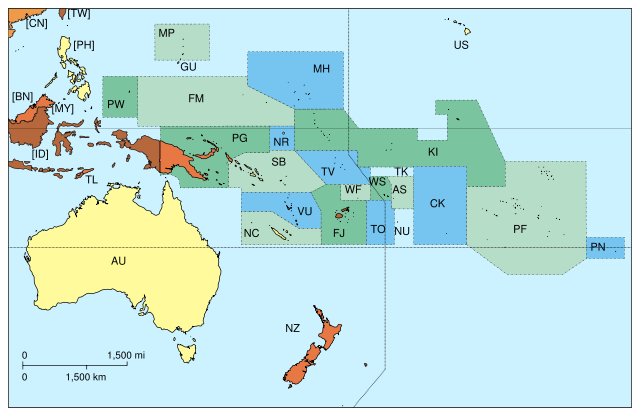
Map of Oceania, with ISO 3166-1 pt · en country and territory code. SVG format. Map legend in Portuguese and English, with name of sovereign state given in parenthesis, where applicable:

  • AS: (pt) Samoa Americana (EUA) · (en) American Samoa (USA) · (fr) Samoa américaines · commons
  • AU: (pt) Austrália · (en) Australia · (fr) Australie · commons
  • CK: (pt) Ilhas Cook · (en) Cook Islands · (fr) Îles Cook · commons
  • FJ: (pt) Fiji · (en) Fiji · (fr) Fidji · commons
  • FM: (pt) Micronésia · (en) Micronesia · (fr) Micronésie · commons
  • GU: (pt) Guam (EUA) · (fr) Guam (USA) ·(fr) Guam · commons
  • KI: (pt) Quiribati · (en) Kiribati · (fr) Kiribati · commons
  • MH: (pt) Ilhas Marshall · (en) Marshall Islands · (fr) Îles Marshall · commons
  • MP: (pt) Marianas Setentrionais · (en) Northern Marianas · (fr) Îles Mariannes du Nord · commons
  • NC: (pt) Nova Caledónia (França) · (en) New Caledonia (France) · (fr) Nouvelle-Calédonie · commons
  • NR: (pt) Nauru · (en) en · (fr) Nauru · commons
  • NU: (pt) Niue (Nova Zelândia) · (en) Niue (New Zealand) · (fr) Niué · commons
  • NZ: (pt) Nova Zelândia · (en) New Zealand · (fr) Nouvelle-Zélande · commons
  • PF: (pt) Polinésia Francesa (França) · (en) French Polynesia (France) · (fr) Polynésie française · commons
  • PG: (pt) Papua-Nova Guiné · (en) Papua-New Guinea · (fr) Papouasie-Nouvelle-Guinée · commons
  • PN: (pt) Pitcairn (Reino Unido) · (en) Pitcairn (United Kingdom) · (fr) Îles Pitcairn · commons
  • PW: (pt) Palau · (en) Palau · (fr) Palaos · commons
  • SB: (pt) Ilhas Salomão · (en) Solomon Islands · (fr) Îles Salomon · commons
  • TL: (pt) Timor-Leste · (en) East Timor · (fr) Timor oriental · commons
  • TK: (pt) Toquelau · (en) Tokelau · (fr) Tokelau · commons
  • TO: (pt) Tonga · (en) Tonga · (fr) Tonga · commons
  • TV: (pt) Tuvalu · (en) Tuvalu · (fr) Tuvalu · commons
  • US: (pt) Havaí (EUA) · (en) Hawai'i (USA) · (fr) Hawaii · commons
  • VU: (pt) Vanuatu · (en) Vanuatu · (fr) Vanuatu · commons
  • WF: (pt) Wallis e Futuna (França) · (en) Wallis and Futuna (France) · (fr) Wallis-et-Futuna · commons
  • WS: (pt) Samoa Ocidental · (en) Western Samoa · (fr) Samoa · commons

On map, but part of Asia:

  • [BN]: (pt) Brunei · (en) Brunei · (fr) Brunei · commons
  • [CN]: (pt) China · (en) People's Republic of China · (fr) République populaire de Chine · commons
  • [ID]: (pt) Indonésia · (en) Indonesia · (fr) Indonésie · commons
  • [MY]: (pt) Malásia · (en) Malaysia · (fr) Malaisie · commons
  • [PH]: (pt) Filipinas · (en) Philippines · (fr) Philippines · commons
  • [TW]: (pt) Taiwan · (en) Taiwan · (fr) Taiwan · commons
Source

Original file

Date

26 May 2006

Author

Júlio Reis

Permission
( Reusing this image)

See below.

Other versions Only continent boundaries: Image:Oceania continents.svg
Asian countries excluded: Image:Oceania without Asian country codes.jpg

Creative Commons License
Creative Commons Attribution icon Creative Commons Share Alike icon
This file is licensed under the Creative Commons Attribution ShareAlike 2.5 License. In short: you are free to share and make derivative works of the file under the conditions that you appropriately attribute it, and that you distribute it only under a license identical to this one. Official license

File history

Click on a date/time to view the file as it appeared at that time.

Date/Time Dimensions User Comment
current 04:24, 21 December 2007 800×520 (162 KB) ButterStick
04:23, 21 December 2007 800×520 (162 KB) ButterStick
04:21, 21 December 2007 800×520 (162 KB) ButterStick (Code optimization)
13:35, 30 May 2006 800×520 (238 KB) Tintazul ( {{Tintazul| |Description=Map of Oceania, with ISO 3166-1 <sup> pt · en</sup> country and territory code. SVG format. Map legend in Portuguese and English, with name of sovereign state given in parenthesis, where appl)
The following pages on Schools Wikipedia link to this image (list may be incomplete):
The 2008 Wikipedia for Schools is sponsored by SOS Children , and is a hand-chosen selection of article versions from the English Wikipedia edited only by deletion (see www.wikipedia.org for details of authors and sources). See also our Disclaimer.