Image:Drury lane inset map.png
From Wikipedia, the free encyclopedia
No higher resolution available.
Drury_lane_inset_map.png (613 × 372 pixels, file size: 377 KB, MIME type: image/png)
| |
This is a file from the Wikimedia Commons. The description on its description page there is shown below. |
Summary
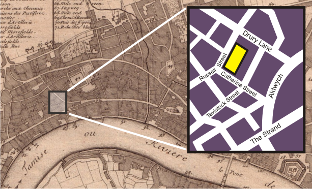
Moved from English Wikipedia:
The background of this image is a section of the Public Domain http://commons.wikimedia.org/wiki/Image:Nicolas_de_fer_1700_london.jpg , a 1700 map of London. The inset map, showing the blocks around the Theatre Royal, Drury Lane in 2006, was drawn by myself, Bunchofgrapes, in Corel Draw.
Licensing
 |
Permission is granted to copy, distribute and/or modify this document under the terms of the GNU Free Documentation license, Version 1.2 or any later version published by the Free Software Foundation; with no Invariant Sections, no Front-Cover Texts, and no Back-Cover Texts. A copy of the license is included in the section entitled " GNU Free Documentation license". Aragonés | العربية | Asturianu | Беларуская (тарашкевіца) | Български | বাংলা | ইমার ঠার/বিষ্ণুপ্রিয়া মণিপুরী | Brezhoneg | Bosanski | Català | Cebuano | Česky | Dansk | Deutsch | Ελληνικά | English | Esperanto | Español | Eesti | Euskara | فارسی | Suomi | Français | Gaeilge | Galego | עברית | Hrvatski | Magyar | Bahasa Indonesia | Ido | Íslenska | Italiano | 日本語 | ქართული | ភាសាខ្មែរ | 한국어 | Kurdî / كوردی | Latina | Lëtzebuergesch | Lietuvių | Bahasa Melayu | Nnapulitano | Nederlands | Norsk (nynorsk) | Norsk (bokmål) | Occitan | Polski | Português | Română | Русский | Slovenčina | Slovenščina | Shqip | Српски / Srpski | Svenska | తెలుగు | ไทย | Tagalog | Türkçe | Українська | اردو | Tiếng Việt | Volapük | Yorùbá | 中文(简体) | 中文(繁體) | +/- |
File history
Click on a date/time to view the file as it appeared at that time.
| Date/Time | Dimensions | User | Comment | |
|---|---|---|---|---|
| current | 19:41, 12 March 2007 | 613×372 (377 KB) | Galileo01 | (Moved from English Wikipedia: ''The background of this image is a section of the Public Domain http://commons.wikimedia.org/wiki/Image:Nicolas_de_fer_1700_london.jpg , a 1700 map of London. The inset map, showing the blocks around the Theatre Royal, Drur) |