Image:SeychellesBIOT1970.jpg
From Wikipedia, the free encyclopedia
Size of this preview: 640 × 232 pixels
Full resolution (780 × 283 pixels, file size: 72 KB, MIME type: image/jpeg)
| |
This is a file from the Wikimedia Commons. The description on its description page there is shown below. |
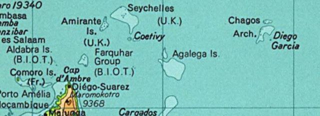
Map of the Seychelles and British Indian Ocean Territory piror to 1976. From the National Atlas as mirrored by the PCL.
 |
This map was obtained from an edition of the National Atlas of the United States. Like almost all works of the U.S. federal government, works from the National Atlas are in the public domain. Online access: NationalAtlas.gov | 1970 print edition: Library of Congress, Perry-Castañeda Library |
 |
This map was cropped from there.
File history
Click on a date/time to view the file as it appeared at that time.
| Date/Time | Dimensions | User | Comment | |
|---|---|---|---|---|
| current | 02:01, 13 August 2005 | 780×283 (72 KB) | Hoshie | (Map of the Seychelles and British Indian Ocean Territory piror to 1976. From the National Atlas as mirrored by the [http://www.lib.utexas.edu/maps/ PCL]. {{PD-USGov-Atlas}} {{PD-PCL|http://www.lib.utexas.edu/maps/national_atlas_1970/ca000244_large.jpg}}) |
File links
The following pages on Schools Wikipedia link to this image (list may be incomplete):