Image:Mongol Empire map.gif
From Wikipedia, the free encyclopedia
Size of this preview: 610 × 479 pixels
Full resolution (752 × 591 pixels, file size: 40 KB, MIME type: image/gif)
| |
This is a file from the Wikimedia Commons. The description on its description page there is shown below. |
[[Image:
|
Example.jpg
|
]]
Summary
| Description |
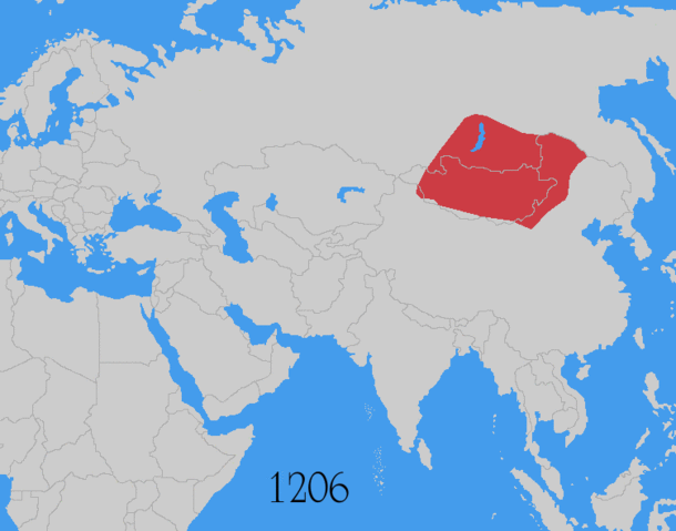
Map showing changes in borders of the Mongol Empire from founding by Genghis Khan in 1206, Genghis Khan's death in 1227 to the rule of Kublai Khan (1260–1294). (Uses modern day borders) ██ Mongol Empire By 1294 the empire had split into: ██ Golden Horde ██ Chagatai Khanate ██ Ilkhanate ██ Yuan Dynasty (Great Khanate) |
|---|---|
| Source |
Based on the freely licenced Image:Genghis khan empire at his death.png using information from maps of the Mongol Empire in atlases and on the web such as , , , , . Made in Photoshop and Painter. |
| Date |
June 2006 |
| Author |
User:Astrokey44 |
| Permission ( Reusing this image) |
self made |
| Other versions | other maps on commons - same animation but with alternative colours, greatest extent, Mongol dominions, 1294 |
Licensing
|

File history
Click on a date/time to view the file as it appeared at that time.
| Date/Time | Dimensions | User | Comment | |
|---|---|---|---|---|
| current | 02:42, 6 August 2008 | 752×591 (40 KB) | Historiographer | (Reverted to version as of 23:06, 31 May 2008) |
| 12:11, 9 July 2008 | 752×591 (162 KB) | Samulili | (reverting to original) | |
| 23:06, 31 May 2008 | 752×591 (40 KB) | Wengier | ({{Information |Description=small fixes |Source=based on original version |Date= |Author= |Permission= |other_versions= }}) | |
| 06:08, 22 June 2006 | 752×591 (162 KB) | Roke | ({{Information |Description= Map showing changes in borders of the w:Mongol Empire |Source= Based on the freely licenced Image:Genghis khan empire at his death.png using information from maps of the Mongol Empire in atlases and on the web such as ) |