Image:East-Hem 323bc.jpg
From Wikipedia, the free encyclopedia
Size of this preview: 640 × 376 pixels
Full resolution (3,240 × 1,903 pixels, file size: 712 KB, MIME type: image/jpeg)
| |
This is a file from the Wikimedia Commons. The description on its description page there is shown below. |
| Description |
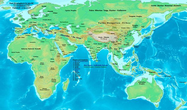
Eastern Hemisphere in 323 BC, at the death of Alexander the Great. |
|||
|---|---|---|---|---|
| Source |
self-made (For reference information, see below) |
|||
| Date | ||||
| Author |
Thomas Lessman ( Contact!) |
|||
| Permission ( Reusing this image) |
|
|||
| Other versions | see East-Hem_323bc.jpg file history on Wikipedia. |
Map Summary
Original Source URL: http://www.thomaslessman.com/History/images/East-Hem_323bc.jpg.
This map of the Eastern Hemisphere in 323 BC was created by Thomas Lessman, based on information from the sources listed below. This map is free for educational use (see Permission info above). When using this map, please mention that it is available for free at www.WorldHistoryMaps.info.
Map Source References
- Remember, sources often conflict with each other. This map is only as accurate as the information that is available to me.
- To report any errors or to help further this work, please use the Corrections page, or email Thomas Lessman at talessman@yis.us
References for information contained in this map:
Empire of Alexander the Great information is derived from:
-
- The DK Atlas of World History, 2000 Edition; map of Alexander's Empire and successors; (Pg. 224)
- Wikimedia's map of The Empire of Alexander the Great uploaded by User_talk:Captain_Blood
- Wikipedia's article about Alexander the Great
I - European Information:
- Roman Republic borders are derived from The DK Atlas of World History, 2000 Edition; Pg. 178; Map of Italy in 240 BCE (also shows Roman borders in 300 BCE).
II - Asian Information:
- Chinese Area borders are derived from this map of The Contending States Boundries c. 350 BC, available on Huhai.net.
- Indian Kingdoms locations are derived from Wikimedia's map of Epic India.
- Gangaridai Note: the borders depicted for Gangaridai are not shown on any maps I've seen, they are described rather vaguely in the sources below:
- This article about The Origins of the Ganga Dynasty - A New Insight by Dr. Harihar Kanungo; (Pg 25, section a).
- This article from Missouri Southern State University about Gangaridae in Megasthenes' Indica; (Section 37).
- The History of Bengal website, which contains extensive information on an archeological site called Chandraketugarh, which may be the lost city of Ganga (the capital of Gangaridai).
- Nanda Dynasty borders are derived from:
- The DK Atlas of World History, 2000 Edition; Map of The Nanda and Mauryan Empires 365-181 BCE; (Pg. 241)
- Văn Lang borders are derived from:
- Wikimedia's map of Van Lang, created by User:Briangotts.
- Wikipedia's articles about Văn Lang and the Hồng Bàng Dynasty.
- Indian Kingdoms locations are derived from Wikimedia's map of Epic India.
III - African Information and info for fringe areas like Africa, Australia, Siberia, etc. derive from:
-
- The DK Atlas of World History, 2000 Edition; map of The development of complex societies in Africa; (Page 160)
- Wikimedia's map of the World_323_BCE, created by User:Briangotts, and
- Wikimedia's map of the World_in_300_BCE, created by User:Javierfv1212.
Note: Much of the information in this map was cross-checked with Bruce Gordon's Regnal Chronologies.
Other Maps by Thomas Lessman
| World History Maps showing history of the World or Eastern Hemisphere. Bold dates are available on Wikimedia or Wikipedia. |
||
| Primeval |
·| 1300 BC | 1200 BC | 1000 BC | 700 BC | 625 BC | |
|
|
|
||
| Ancient BC / BCE
AD / CE |
·| 600 BC | 550 BC | 527 BC | 500 BC | 400 BC | ·| 001 AD | 050 AD | 100 AD | 200 AD | 300 AD | |
|
| Medieval |
·| 500 AD | 525 AD | 565 AD | 600 AD | 700 AD | |
|
| Modern |
·| 1500 AD | · * For more maps after 1500 AD (and before), |
|
Original upload log
The original description page is/was here. All following user names refer to en.wikipedia.
- 2007-12-21 15:09 Talessman 3240×1903×8 (717376 bytes) Corrected info for Far eastern peoples, more info for Africa and Europe
- 2007-11-21 19:34 Talessman 3240×1903×8 (697847 bytes) Added info on lesser-known cultures. Also changed text colour of Helenistic states to Blue, of Iranian peoples to green, and added names of smaller nations (numbered legend).
- 2007-11-06 22:20 Talessman 3240×1903×8 (689151 bytes) Corrected borders in Sudan (Meroe) and Arabia, added info for Japan, Indonesia, etc.
- 2007-10-02 17:49 Talessman 2880×1692×8 (546378 bytes) Author: Thomas A. Lessman. Source URL: http://www.ThomasLessman.com/History/images/East-Hem_323bc.jpg. Image was created by me (Thomas Lessman) based on historical information located on Wikipedia, as well as information from maps located in Wikipedia and
- 2007-09-12 21:35 Talessman 2880×1692×8 (514268 bytes) Author: Thomas A. Lessman. Source URL: http://www.ThomasLessman.com/History/images/East-Hem_323bc.jpg. Image was created by me (Thomas Lessman) based on historical information located on Wikipedia, as well as information from maps located in Wikipedia and
File history
Click on a date/time to view the file as it appeared at that time.
| Date/Time | Dimensions | User | Comment | |
|---|---|---|---|---|
| current | 07:37, 23 May 2008 | 3,240×1,903 (712 KB) | Talessman | (Corrected borders of Rome, Carthage, Alexander's Empire, Nanda Empire, and China. Also corrected placement of Tocharians, added more info for Europe, India, Africa, and East Asia.) |
| 14:53, 9 May 2008 | 3,240×1,903 (708 KB) | Talessman | ({{Information |Description='''Eastern Hemisphere in 500 BC'''. |Source=self-made (For reference information, see below) |Author= Thomas Lessman ( Contact!) |Permission={{self|cc-by-sa-3.0}} }}) |