Image:Red Sea topographic map-en.jpg

From Wikipedia, the free encyclopedia

Wikimedia Commons logo This is a file from the Wikimedia Commons. The description on its description page there is shown below.
Commons is a freely licensed media file repository. You can help.

Summary

Camera location

21°00′00″N, 38°00′00″E

This and other geocoded Commons images:
( Info)


Description
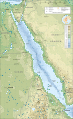
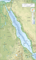
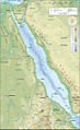
English: Topographic map in English of the Red Sea, UTM projection (WGS84 datum).
Note : for translation purpose, use the SVG version.
Français : Carte topographique en anglais de la Mer Rouge, projection UTM (WGS84 datum).

Scales :
* Topographic and bathymetric data : 1:3,708,000 (accuracy : 930 m)
* Shorelines and additional data : 1:8,160,000 (accuracy : 2,040 m) (printing size : 18.8 x 30.73 cm).

Approximate geographic limits of the map (30" close) :
* SW corner : 10° N – 31° 17' E
* S-centre point : 10° 06' N – 38° E
* SE corner : 10° 03' N – 44° 45' E
* NE corner : 31° 47' N – 45° 40' E
* N-centre point : 31° 57' N – 37° 49' E
* NW corner : 31° 39' N – 30° 04' E

Source

Own work (see complete description on Image:Red_Sea_topographic_map-en.svg)

Date

April 2008

Author

Eric Gaba ( Sting - fr:Sting)

Permission
( Reusing this image)

GFDL / Attribution and Share-Alike required

Other versions


Atelier graphique
Remarque
English: This map was made or improved by the Wikigraphists of the Atelier graphique. You can propose maps or images to clean up and improve as well.
Esperanto: Ĉi tiu mapo estis kreita aŭ plibonigita de la Vikigrafistoj el la Grafika laborgrupo. Vi ankaŭ povas tie proponi mapojn aŭ bildojn plibonigendajn.
Español: Este mapa ha sido confeccionado o mejorado por los Wikígrafos del Taller gráfico. Puedes proponer la mejora de cualquier imagen a través de la página de Peticiones.
Français : Cette carte a été créée ou améliorée par les Wikigraphistes de l' Atelier graphique. Vous pouvez également y proposer des cartes ou des images à améliorer.
Türkçe: Bu harita Atelier graphique'ten Wikigraphistes'ler tarafından yapıldı veya geliştirildi. Siz de haritalar veya resimleri temizlemek veya geliştirmek için teklif edebilirsiniz.


Licensing

I, the copyright holder of this work, hereby publish it under the following licenses:
GNU head Permission is granted to copy, distribute and/or modify this document under the terms of the GNU Free Documentation license, Version 1.2 or any later version published by the Free Software Foundation; with no Invariant Sections, no Front-Cover Texts, and no Back-Cover Texts. A copy of the license is included in the section entitled " GNU Free Documentation license".

Aragonés | العربية | Asturianu | Беларуская (тарашкевіца) | Български | বাংলা | ইমার ঠার/বিষ্ণুপ্রিয়া মণিপুরী | Brezhoneg | Bosanski | Català | Cebuano | Česky | Dansk | Deutsch | Ελληνικά | English | Esperanto | Español | Eesti | Euskara | فارسی | Suomi | Français | Gaeilge | Galego | עברית | Hrvatski | Magyar | Bahasa Indonesia | Ido | Íslenska | Italiano | 日本語 | ქართული | ភាសាខ្មែរ | 한국어 | Kurdî / كوردی | Latina | Lëtzebuergesch | Lietuvių | Bahasa Melayu | Nnapulitano | Nederlands | ‪Norsk (nynorsk)‬ | ‪Norsk (bokmål)‬ | Occitan | Polski | Português | Română | Русский | Slovenčina | Slovenščina | Shqip | Српски / Srpski | Svenska | తెలుగు | ไทย | Tagalog | Türkçe | Українська | اردو | Tiếng Việt | Volapük | Yorùbá | ‪中文(简体)‬ | ‪中文(繁體)‬ | +/-

Some rights reserved
Creative Commons Attribution icon Creative Commons Share Alike icon
This file is licensed under the Creative Commons Attribution ShareAlike license versions 3.0, 2.5, 2.0, and 1.0

Български | Català | Česky | Dansk | Deutsch | Ελληνικά | English | Español | Euskara | Estremeñu | Français | עברית | Italiano | 日本語 | 한국어 | Lietuvių | Nederlands | ‪Norsk (bokmål)‬  | Occitan | Polski | Piemontèis | Português | Русский | 中文 | +/-

You may select the license of your choice.

File history

Click on a date/time to view the file as it appeared at that time.

Date/Time Dimensions User Comment
current 19:35, 3 April 2008 1,655×2,705 (1.67 MB) Sting (Additional corrections)
13:09, 3 April 2008 1,655×2,705 (1.71 MB) Sting (Some names corrections ; some improvements)
11:26, 3 April 2008 1,655×2,705 (1.67 MB) Sting (Little correction)
22:32, 2 April 2008 1,655×2,705 (1.7 MB) Sting ({{Location|21|00|00|N|38|00|00|E|scale:10000000}} <br/> {{Information |Description={{en|Topographic map in English of the red Sea<br/>''Note :'' for translation purpose, use the SVG version.}} {{fr)
The following pages on Schools Wikipedia link to this image (list may be incomplete):

Metadata

This file contains additional information, probably added from the digital camera or scanner used to create or digitize it. If the file has been modified from its original state, some details may not fully reflect the modified file.

The Schools Wikipedia is sponsored by SOS Children , and is mainly selected from the English Wikipedia with only minor checks and changes (see www.wikipedia.org for details of authors and sources). See also our Disclaimer.