Image:United States 1803-04-1804-03-narrow.jpg
From Wikipedia, the free encyclopedia
No higher resolution available.
United_States_1803-04-1804-03-narrow.jpg (555 × 470 pixels, file size: 59 KB, MIME type: image/jpeg)
| Description |
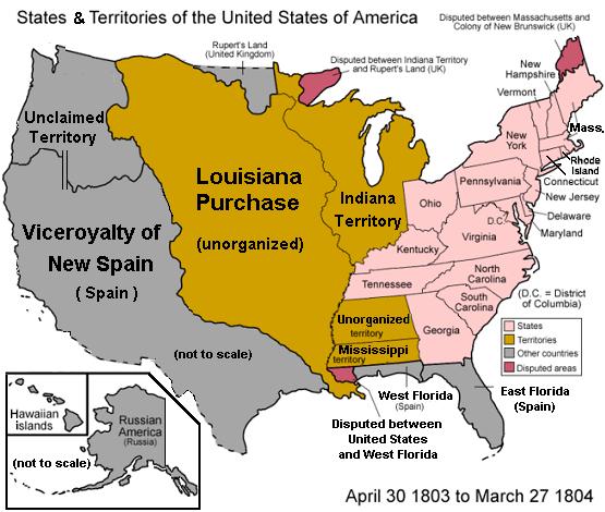
Map of the states and territories of the United States as it was from April 1803 to March 1804. On April 30 1803, Louisiana was purchased from France, and a dispute arose if it included a portion of West Florida. On March 27 1804, the lands previously ceded by Georgia were added to Mississippi Territory. |
|---|---|
| Source |
Image:United States 1803-04-1804-03.png |
| Date |
28 January 2007 |
| Author |
Made by User:Golbez, then compressed as 70% wide with larger labels. |
| Permission ( Reusing this image) |
Own work, attribution required (Multi-license with GFDL and Creative Commons CC-BY 2.5) |
| Other versions | Image:United States 1803-04-1804-03.png (44% wider). |
|
Template:USA territorial evolution
| |
This image was uploaded in the JPEG format even though it consists of non-photographic data. The information it contains could be stored more efficiently or more accurately in the PNG format or SVG format. If possible, please upload a PNG or SVG version of this image, derived from a non-JPEG source so that it doesn't contain any compression artifacts (or with existing artifacts removed) and with transparency where appropriate. After doing so, please replace all instances of the JPEG version throughout Wikipedia (noted under the "File links" header), tag the JPEG version with {{ obsolete|NewImage.ext}}, and remove this tag. For more information, see Wikipedia:Preparing images for upload. |
File history
Click on a date/time to view the file as it appeared at that time.
| Date/Time | Dimensions | User | Comment | |
|---|---|---|---|---|
| current | 01:43, 29 January 2007 | 555×470 (59 KB) | Wikid77 ( Talk | contribs) | ({{Information| |Description=Map of the states and territories of the United States as it was from April 1803 to March 1804. On April 30 1803, Louisiana was purchased from France, and a dispute arose if it included a portion of West Florida. On March 27 18) |
See the setup instructions for more information.
File links
The following pages on Schools Wikipedia link to this image (list may be incomplete):
Categories: Creative Commons Attribution 2.5 images | Self-published work | Territorial Growth Maps of the United States | Images with inappropriate JPEG compression