Image:Nashville Population Density 2000.png
From Wikipedia, the free encyclopedia
Size of this preview: 573 × 479 pixels
Full resolution (1,064 × 890 pixels, file size: 112 KB, MIME type: image/png)
Summary
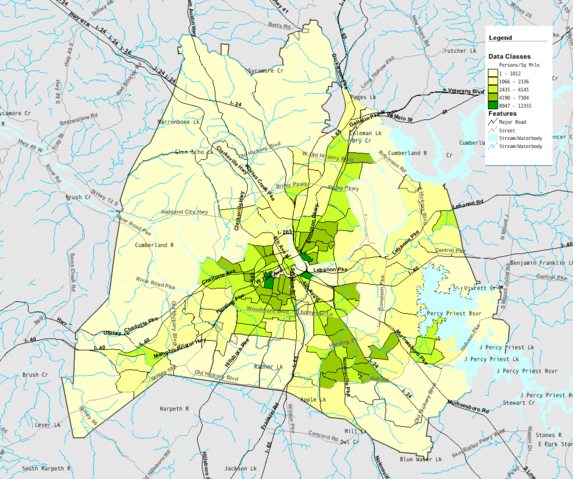
From the United States Census Bureau's Fact Finder website: Source. This map shows the city of Nashville, Tennessee, USA by average number of inhabitants per square mile of land in 2000. Montage of 9 images by Drumguy8800.
Licensing
 |
This image is a work of a United States Census Bureau employee, taken or made during the course of an employee's official duties. As a work of the U.S. federal government, the image is in the public domain. Subject to disclaimers. |  |
 |
This is a candidate to be copied to the Wikimedia Commons, but no category on the Commons has been selected to receive this file. To solve the problem, please select the proper category on the Commons and add it to this page.
Wikipedia is not a collection of photographs or media files and appropriately licensed media are more accessible to other Wikimedia projects if placed on Commons. Any user may perform this move — please see Moving images to the Commons for more information. Copy to Commons via CommonsHelper, which can automatically categorize the image for you. |
File history
Click on a date/time to view the file as it appeared at that time.
| Date/Time | Dimensions | User | Comment | |
|---|---|---|---|---|
| current | 19:44, 21 October 2006 | 1,064×890 (112 KB) | Kaldari ( Talk | contribs) | (tightening up the cropping) |
| revert | 18:53, 21 October 2006 | 1,434×1,052 (368 KB) | Drumguy8800 ( Talk | contribs) | (== Summary == From the United States Census Bureau's [http://factfinder.census.gov Fact Finder website]: [http://factfinder.census.gov/servlet/ACSSAFFFacts?_event=&geo_id=16000US4752006&_geoContext=01000US%7C04000US47%7C16000US4752006&_street=&_county) |
See the setup instructions for more information.
File links
The following pages on Schools Wikipedia link to this image (list may be incomplete):
Categories: Census Bureau images | Copy to Wikimedia Commons