Image:Australia-climate-map MJC01.png
From Wikipedia, the free encyclopedia
Size of this preview: 530 × 480 pixels
Full resolution (1,000 × 905 pixels, file size: 32 KB, MIME type: image/png)
| |
This is a file from the Wikimedia Commons. The description on its description page there is shown below. |
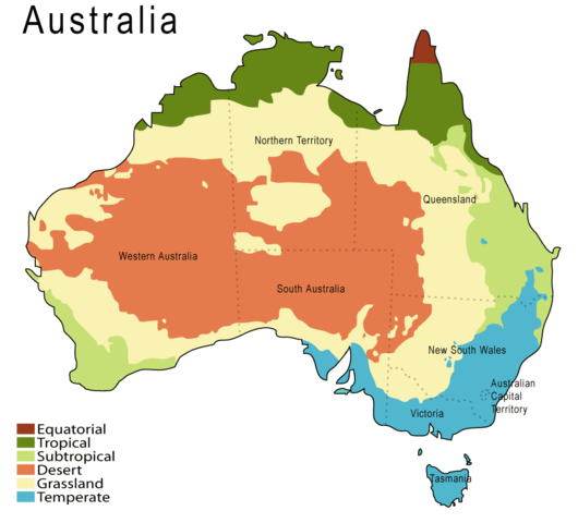
A climate map of Australia. Based on a map from the Australian Bureau of Meteorology http://www.bom.gov.au.
See:
Australian climate zones - major classification groups (based on the Köppen classification)
 |
This map image should be recreated using vector graphics as an SVG file. This has several advantages; see Commons:Media for cleanup for more information. If an SVG form of this image is already available, please upload it. After uploading an SVG, replace this template with {{ vector version available|new image name.svg}}. |
|
العربية | Български | Català | Česky | Dansk | Deutsch | English | Esperanto | Español | Français | Galego | 한국어 | Italiano | Magyar | Lietuvių | Nederlands | 日本語 | Polski | Português | Română | Русский | Suomi | Svenska | Türkçe | Українська | 中文(繁體) | 中文(简体) | +/- |
|
|
NOTE: "subject to disclaimers" below may not actually apply, this was tagged with {{ GFDL-user-en}}, and after May 2007, w:en:Template:GFDL-self did not require disclaimers. Please check the image description page on the English Wikipedia (or, if it has been deleted, ask an English Wikipedia administrator). See Wikipedia:GFDL standardization for details. |
|||
|
|||
|
Note: This tag should not be used. For images that were released on the English Wikipedia using either GFDL or GFDL-self with disclaimers, use {{ GFDL-user-en-with-disclaimers}}. For images without disclaimers please use {{ GFDL-user-en-no-disclaimers}} instead. If you are the copyright holder of files that were released on Wikipedia consider removing the disclaimers. |

(del) (cur) 02:38, 26 September 2005 . . Martyman (Talk) . . 1000x905 (41677 bytes) (Upload new version at higher resolution and slightly changed colours.)
(del) (rev) 00:15, 26 August 2005 . . Martyman (Talk) . . 800x724 (33965 bytes) (A climate map of Australia drawn be me in Illustrator {{GFDL}})
File history
Click on a date/time to view the file as it appeared at that time.
| Date/Time | Dimensions | User | Comment | |
|---|---|---|---|---|
| current | 18:45, 1 January 2008 | 1,000×905 (32 KB) | Mahahahaneapneap | (pngcrushed) |
| 18:45, 25 October 2007 | 1,000×905 (41 KB) | Denniss | ||
| 18:03, 3 September 2007 | 662×599 (149 KB) | Rosarinagazo | ({{Information |Description=A climate map of Australia. Based on a map from the Australian Bureau of Meteorology http://www.bom.gov.au. Australian climate zones - major classification groups (based on the Köppen classification) |Source=http://en.wikipedia) | |
| 00:28, 3 February 2006 | 1,000×905 (41 KB) | Grillo | (A climate map of Australia drawn by me in Illustrator. Based on a map from the Australian Bureau of Meteorology [http://www.bom.gov.au http://www.bom.gov.au]. {{GFDL}} (del) (cur) 02:38, 26 September 2005 . . Martyman (Talk) . . 1000x905 (41677 bytes) () |