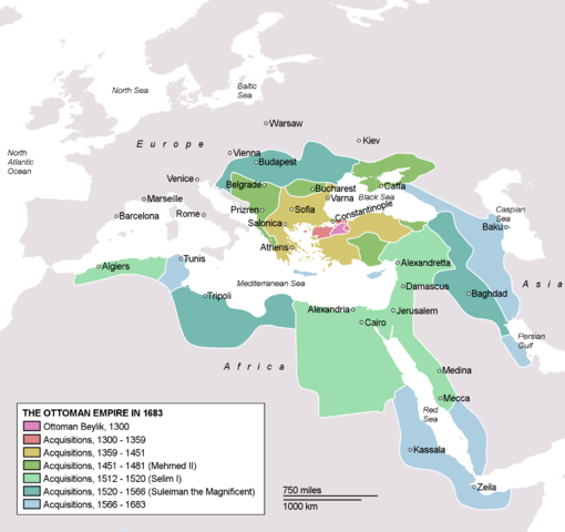
Image:OttomanEmpireIn1683.png
From Wikipedia, the free encyclopedia

Size of this preview: 510 × 480 pixels
Full resolution (1,966 × 1,850 pixels, file size: 327 KB, MIME type: image/png)
File history
Click on a date/time to view the file as it appeared at that time.
| Date/Time | Dimensions | User | Comment | |
|---|---|---|---|---|
| current | 15:12, 26 March 2007 | 1,966×1,850 (327 KB) | AtilimGunesBaydin | (Updated Ionian Islands.) |
| 01:25, 15 March 2007 | 1,966×1,850 (303 KB) | Stevanb | (Corrected some error. Very important (historical) Ottoman "city" in Balkan area is Prizren - on the map marked as Kosovo. Kosovo is region, Prizren is town (Ottoman "city").) | |
| 16:28, 25 February 2007 | 1,966×1,850 (327 KB) | AtilimGunesBaydin | (Minor update.) | |
| 02:34, 18 February 2007 | 1,966×1,850 (327 KB) | AtilimGunesBaydin | (Update territories, some city locations and labels.) | |
| 23:50, 14 February 2007 | 1,940×1,500 (306 KB) | AtilimGunesBaydin | (Minor fixes, updated some borders and the colour scheme.) | |
| 00:55, 23 December 2006 | 1,684×1,348 (283 KB) | AtilimGunesBaydin | (Added more labels.) | |
| 17:47, 21 December 2006 | 1,684×1,347 (244 KB) | AtilimGunesBaydin | ({{Information |Description=Map depicting the Ottoman Empire at its greatest extent, in 1683. |Source=Self drawn, based on information mainly compiled from Image:Ottoman 1683.png, [http://fs.huntingdon.edu/jlewis/Syl/IRcomp/Maps) |
File links
The following pages on Schools Wikipedia link to this image (list may be incomplete):
Categories: Maps of the Ottoman Empire


