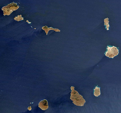
Image:Satellite image of Cape Verde in December 2002.jpg
From Wikipedia, the free encyclopedia
Size of this preview: 513 × 479 pixels
Full resolution (1,189 × 1,111 pixels, file size: 485 KB, MIME type: image/jpeg)
| |
This is a file from the Wikimedia Commons. The description on its description page there is shown below. |
| Description |
Español: Imagen satélite de las islas de Cabo Verde
English: satellite image of the Cape Verde Islands
Português: imagem de satélite das ilhas de Cabo Verde
|
|||||
|---|---|---|---|---|---|---|
| Source |
Cropped image, original taken from NASA's Visible Earth http://visibleearth.nasa.gov/view_rec.php?id=4638 |
|||||
| Date |
2002-12-31 |
|||||
| Author |
NASA's Visible Earth |
|||||
| Permission ( Reusing this image) |
|
|||||
| Other versions |
 |


File history
Click on a date/time to view the file as it appeared at that time.
| Date/Time | Dimensions | User | Comment | |
|---|---|---|---|---|
| current | 17:48, 6 May 2008 | 1,189×1,111 (485 KB) | Waldir | (less destructive enhancement) |
| 12:25, 16 April 2008 | 1,189×1,111 (140 KB) | AVM | (Colour-enhanced version of previous image) | |
| 14:32, 26 December 2004 | 1,189×1,111 (70 KB) | Hautala | ({{PD-USGov-NASA}} Satellite image of Cape Verde in December 2002. Cropped image, original taken from NASA's Visible Earth http://visibleearth.nasa.gov/cgi-bin/viewrecord?23101) |
File links
The following pages on Schools Wikipedia link to this image (list may be incomplete):
Metadata
This file contains additional information, probably added from the digital camera or scanner used to create or digitize it. If the file has been modified from its original state, some details may not fully reflect the modified file.
| Orientation | Normal |
|---|---|
| Horizontal resolution | 72 dpi |
| Vertical resolution | 72 dpi |
| Software used | Adobe Photoshop CS2 Windows |
| File change date and time | 18:47, 6 May 2008 |
| Colour space | 65535 |