Image:Washington DC Panorama.jpg

From Wikipedia, the free encyclopedia
Wikimedia Commons logo This is a file from the Wikimedia Commons. The description on its description page there is shown below.
Commons is a freely licensed media file repository. You can help.

Summary

Description
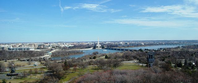
English: View on Washington DC from Arlington, Va, from so called "Top of the Town". Some of the visible landmarks: Iwo Jima Memorial aka Marines War Memorial (bottom left), Theodore Roosevelt Bridge (bridge on the left), Theodore Roosevelt Island, John F. Kennedy Centre for the Performing Arts (across the river on the left from the bridge), Watergate complex (on the left from Kennedy Centre), Washington Monument (centre), Lincoln Memorial (directly in front of Washington Monument), Arlington Memorial Bridge (bridge on the right), Tidal Basin (above the bridge), Thomas Jefferson Memorial (to the right of the Basin), 14th Street Bridge (far right bridge), Netherlands Carillon (black tower up-close on the Virginia side), and Arlington Cemetery.
Polski: Widok na Waszyngton z za rzeki z Arlington w stanie Wirginia. Niektore z widocznych objektów: Iwo Jima Memorial (Pomnik Korpusu Piechoty Morskiej po lewej na dole), Most Teodora Roosevelta (most po lewej), Wyspa Teodora Roosevelta, Teatr Johna F. Kennedy (po drugiej stronie rzeki po lewej od mostu), apartamenty Watergate (po lewej od Teatru Kennedy), Pomnik Waszyngtona (po środku), Pomnik Lincolna (przed Pomnikiem Waszyngtona u jego podstawy), Most Arlington Memorial (most po prawej), Pomnik Tomasza Jeffersona (biały okrągły budynek "ponad" mostem), Most 14-stej Ulicy (skrajny po prawej), Holenderska Dzwonnica (czarna wieża z przodu po prawej stronie), i Narodowy Cmentarz w Arlington.
Source

self-made

Date

March 14 2008

Author

Jarek Tuszynski (aka Jarekt)

Permission
( Reusing this image)

see below

Other versions

Pictures from the same location and time

Camera location

38.88921652656352° N, 77.0726591349° W

See this image at its location on Google Maps

This location on: Live Maps - Trails.com - TerraServer-USA

Licensing

I, the copyright holder of this work, hereby publish it under the following licenses:
GNU head Permission is granted to copy, distribute and/or modify this document under the terms of the GNU Free Documentation license, Version 1.2 or any later version published by the Free Software Foundation; with no Invariant Sections, no Front-Cover Texts, and no Back-Cover Texts. A copy of the license is included in the section entitled " GNU Free Documentation license".

Aragonés | العربية | Asturianu | Беларуская (тарашкевіца) | Български | বাংলা | ইমার ঠার/বিষ্ণুপ্রিয়া মণিপুরী | Brezhoneg | Bosanski | Català | Cebuano | Česky | Dansk | Deutsch | Ελληνικά | English | Esperanto | Español | Eesti | Euskara | فارسی | Suomi | Français | Gaeilge | Galego | עברית | Hrvatski | Magyar | Bahasa Indonesia | Ido | Íslenska | Italiano | 日本語 | ქართული | ភាសាខ្មែរ | 한국어 | Kurdî / كوردی | Latina | Lëtzebuergesch | Lietuvių | Bahasa Melayu | Nnapulitano | Nederlands | ‪Norsk (nynorsk)‬ | ‪Norsk (bokmål)‬ | Occitan | Polski | Português | Română | Русский | Slovenčina | Slovenščina | Shqip | Српски / Srpski | Svenska | తెలుగు | ไทย | Tagalog | Türkçe | Українська | اردو | Tiếng Việt | Volapük | Yorùbá | ‪中文(简体)‬ | ‪中文(繁體)‬ | +/-

Some rights reserved
Creative Commons Attribution icon Creative Commons Share Alike icon
This file is licensed under the Creative Commons Attribution ShareAlike license versions 3.0, 2.5, 2.0, and 1.0

Български | Català | Česky | Dansk | Deutsch | Ελληνικά | English | Español | Euskara | Estremeñu | Français | עברית | Italiano | 日本語 | 한국어 | Lietuvių | Nederlands | ‪Norsk (bokmål)‬  | Occitan | Polski | Piemontèis | Português | Русский | 中文 | +/-

You may select the license of your choice.

File history

Click on a date/time to view the file as it appeared at that time.

Date/Time Dimensions User Comment
current 02:56, 24 April 2008 3,008×1,262 (1.65 MB) Jarekt (== Summary == {{Information |Description={{en|View on Washington DC from Arlington, Va}} |Source=self-made |Date=2008 |Author= Jarek Tuszynski (aka Jarekt) |Permission= |other_versions= }} {{location dec|38.88921652656352|-77.07265913486481)
The following pages on Schools Wikipedia link to this image (list may be incomplete):

Metadata

This file contains additional information, probably added from the digital camera or scanner used to create or digitize it. If the file has been modified from its original state, some details may not fully reflect the modified file.

The Schools Wikipedia is sponsored by SOS Children , and is mainly selected from the English Wikipedia with only minor checks and changes (see www.wikipedia.org for details of authors and sources). See also our Disclaimer.